
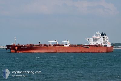
STI SLOANE
Tanker
Current Trip
| Time Travelled | --- |
|---|---|
| Remaining Time | --- |
| Distance Travelled | 11002.92 морская миля |
| Remaining Distance | --- |
| AVG Speed | 11.4 Узлы |
| MAX Speed | 15.7 Узлы |
| AVG Wind | 10 knots |
| MAX Wind | 28 knots |
| MIN Temp | 17.7°C / 63.86°F |
| MAX Temp | 29.9°C / 85.82°F |
| Осадка | 14.8 м |
| Позиция Получена | 3 d тому назад |
Current Position
| Долгота | 17.98908° |
|---|---|
| Широта | -34.59750° |
| Статус | Under way using engine |
| Скорость | 13.7 Узлы |
| Курс | 290.6° |
| Район | South Atlantic Ocean |
| Станция | T-AIS |
| Позиция Получена | 3 d тому назад |
Info
Information
The current position of STI SLOANE is in South Atlantic Ocean with coordinates -34.59750° / 17.98908° as reported on 2024-04-16 01:57 by AIS to our vessel tracker app. The vessel's current speed is 13.7 Узлы and is heading at the port of LE HAVRE. The estimated time of arrival as calculated by MyShipTracking vessel tracking app is 2024-05-05 10:00 LT
The vessel STI SLOANE (IMO: 9690808, MMSI: 538005387) is a Tanker It's sailing under the flag of [MH] Marshall Is.
In this page you can find informations about the vessels current position, last detected port calls, and current voyage information. If the vessels is not in coverage by AIS you will find the latest position.
The current position of STI SLOANE is detected by our AIS receivers and we are not responsible for the reliability of the data. The last position was recorded while the vessel was in Coverage by the Ais receivers of our vessel tracking app.
The current draught of STI SLOANE as reported by AIS is 14.8 meters
Weather
| Temperature | 21.9°C / 71.42°F |
|---|---|
| Wind Speed | 11 knots |
| Direction | 110° ESE |
| Pressure | 1014.4 hPa |
| Humidity | 83.8 % |
| Cloud Coverage | 81 % |
Featured Company
Events
| Время | Событие | Детали | Позиция / Направление | Информация |
|---|---|---|---|---|
| 2024-04-16 02:01 | Статус изменился | Default Under way using engine |
-34.59253 / 17.97327
FR LEH
|
Скорость: 13.7 kn Курс: 290.6° |
| 2024-04-16 01:57 | Вне покрытия |
-34.59750 / 17.98908
South Atlantic Ocean
FR LEH
|
Скорость: 13.7 kn Курс: 290.6° |
|
| 2024-04-16 01:50 | Статус изменился | Under way using engine Default |
-34.60616 / 18.01727
FR LEH
|
Скорость: 13.6 kn Курс: 297° |
| 2024-04-16 01:16 | Статус изменился | Default Under way using engine |
-34.66500 / 18.15667
FR LEH
|
Скорость: 13.4 kn Курс: 298.3° |
| 2024-04-16 01:12 | Статус изменился | Under way using engine Default |
-34.67347 / 18.17576
FR LEH
|
Скорость: 13.4 kn Курс: 298° |
| 2024-04-16 01:09 | Статус изменился | Default Under way using engine |
-34.67788 / 18.18575
FR LEH
|
Скорость: 13.4 kn Курс: 298.1° |
| 2024-04-15 23:36 | Статус изменился | Under way using engine Default |
-34.87562 / 18.50720
FR LEH
|
Скорость: 13.2 kn Курс: 303° |
| 2024-04-15 23:29 | В покрытии |
-34.87528 / 18.50658
South Atlantic Ocean
FR LEH
|
Скорость: 13.2 kn Курс: 303.9° |
|
| 2024-04-15 22:13 | Статус изменился | Default Under way using engine |
-34.94333 / 18.86167
FR LEH
|
Скорость: 12.9 kn Курс: 279.8° |
| 2024-04-15 22:05 | Вне покрытия |
-34.94900 / 18.89573
South Atlantic Ocean
FR LEH
|
Скорость: 12.9 kn Курс: 279.8° |