
RISING TIDE
Cargo
Current Trip
| Time Travelled | 11 days |
|---|---|
| Remaining Time | --- |
| Distance Travelled | 1998.45 морская миля |
| Remaining Distance | 29.72 морская миля |
| AVG Speed | 9.6 Узлы |
| MAX Speed | 13.6 Узлы |
| AVG Wind | 10.8 knots |
| MAX Wind | 27.3 knots |
| MIN Temp | 12.1°C / 53.78°F |
| MAX Temp | 25.9°C / 78.62°F |
| Осадка | 7.1 м |
| Позиция Получена | 4 d тому назад |
Current Position
| Долгота | --- |
|---|---|
| Широта | --- |
| Статус | Under way using engine |
| Скорость | 2.7 Узлы |
| Курс | 264° |
| Район | South China Sea |
| Станция | T-AIS |
| Позиция Получена | 4 d тому назад |
Info
Information
The current position of RISING TIDE is in South China Sea with coordinates 22.21796° / 120.22984° as reported on 2025-12-04 10:11 by AIS to our vessel tracker app. The vessel's current speed is 2.7 Узлы and is heading at the port of HONG KONG. The estimated time of arrival as calculated by MyShipTracking vessel tracking app is 2025-12-03 22:00 LT
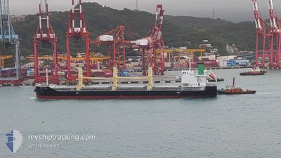
The vessel RISING TIDE (IMO: 9889693, MMSI: 372552000) is a Cargo It's sailing under the flag of [PA] Panama.
In this page you can find informations about the vessels current position, last detected port calls, and current voyage information. If the vessels is not in coverage by AIS you will find the latest position.
The current position of RISING TIDE is detected by our AIS receivers and we are not responsible for the reliability of the data. The last position was recorded while the vessel was in Coverage by the Ais receivers of our vessel tracking app.
The current draught of RISING TIDE as reported by AIS is 7.1 meters
Weather
| Temperature | 20.5°C / 68.9°F |
|---|---|
| Wind Speed | 24 knots |
| Direction | 67° ENE |
| Pressure | 1021.2 hPa |
| Humidity | 66.3 % |
| Cloud Coverage | 1 % |
Featured Company
Last Port Calls
| Port | Arrival | Departure | Time In Port |
|---|---|---|---|
| 2025-11-26 06:16 | 2025-11-28 09:33 | 2 d | |
| 2025-11-10 14:36 | 2025-11-11 12:11 | 21 h | |
| 2025-11-04 19:48 | 2025-11-05 13:11 | 17 h | |
| 2025-10-27 07:40 | 2025-10-31 11:36 | 4 d | |
| 2025-10-10 21:48 | 2025-10-14 02:48 | 3 d | |
| 2025-10-03 08:48 | 2025-10-05 06:28 | 1 d |
Last Trips
| Origin | Departure | Destination | Arrival | Distance | |
|---|---|---|---|---|---|
| 2025-11-11 12:11 | 2025-11-26 06:16 | 1571.30 морская миля | |||
| 2025-11-05 13:11 | 2025-11-10 14:36 | 1277.80 морская миля | |||
| 2025-10-31 11:36 | 2025-11-04 19:48 | 821.65 морская миля | |||
| 2025-10-14 02:48 | 2025-10-27 07:40 | 2881.25 морская миля | |||
| 2025-10-05 06:28 | 2025-10-10 21:48 | 957.56 морская миля | |||
| 2025-09-21 11:34 | 2025-10-03 08:48 | 2983.97 морская миля |
Events
| Время | Событие | Детали | Позиция / Направление | Информация |
|---|---|---|---|---|
| 2025-12-08 13:37 | Начало движения | 15.85 nm, South East of WAILINGDING ISLAND |
21.97058 / 114.27029
HK HKG
|
Скорость: 4.8 kn Курс: 225° |
| 2025-12-08 09:45 | Окончание движения | 18.18 nm, East of WAILINGDING ISLAND |
21.99255 / 114.32748
HK HKG
|
Скорость: 0.2 kn Курс: 140° |
| 2025-12-07 21:57 | Начало движения |
21.99280 / 114.40869
HK HKG
|
Скорость: 3.7 kn Курс: 240° |
|
| 2025-12-07 20:17 | Окончание движения | 21.4 nm, South East of HONG KONG |
22.01077 / 114.41958
HK HKG
|
Скорость: 0.3 kn Курс: 3° |
| 2025-12-07 17:09 | Начало движения | 20.12 nm, South East of HONG KONG |
22.01809 / 114.39216
HK HKG
|
Скорость: 3.2 kn Курс: 91° |
| 2025-12-07 15:57 | Окончание движения | 20.01 nm, South East of HONG KONG |
22.01596 / 114.38555
HK HKG
|
Скорость: 0.2 kn Курс: 1° |
| 2025-12-06 18:09 | Начало движения | 7.33 nm, South of HONG KONG |
22.16784 / 114.18018
HK HKG
|
Скорость: 4.5 kn Курс: 135° |
| 2025-12-06 13:34 | Окончание движения | 7.42 nm, South of HONG KONG |
22.16643 / 114.17466
HK HKG
|
Скорость: 0.3 kn Курс: 73° |
| 2025-12-04 10:16 | Статус изменился | Default Under way using engine |
22.21689 / 120.22786
HK HKG
|
Скорость: 2.7 kn Курс: 264° |
| 2025-12-04 10:11 | Вне покрытия |
22.21796 / 120.22984
South China Sea
|
Скорость: 2.7 kn Курс: 230.7° |