
ALBERTE HOJ
Grab Dredger
Current Trip
DKLOG
| Time Travelled | 21 days |
|---|---|
| Remaining Time | --- |
| Distance Travelled | 922.23 морская миля |
| Remaining Distance | --- |
| AVG Speed | 5.1 Узлы |
| MAX Speed | 8.3 Узлы |
| AVG Wind | 11.1 knots |
| MAX Wind | 25.5 knots |
| MIN Temp | 0.6°C / 33.08°F |
| MAX Temp | 14.5°C / 58.1°F |
| Осадка | 2 м |
| Позиция Получена | 2 m тому назад |
Current Position
| Долгота | 9.25789° |
|---|---|
| Широта | 56.97069° |
| Статус | Moored |
| Скорость | 0.1 Узлы |
| Курс | 70° |
| Район | North Sea |
| Станция | T-AIS |
| Позиция Получена | 2 m тому назад |
Info
Information
The current position of ALBERTE HOJ is in North Sea with coordinates 56.97069° / 9.25789° as reported on 2024-04-24 02:31 by AIS to our vessel tracker app. The vessel's current speed is 0.1 Узлы
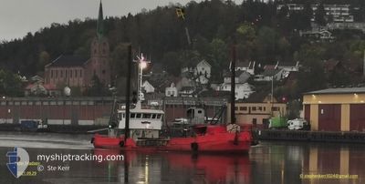
The vessel ALBERTE HOJ (IMO: 6825581, MMSI: 219001262) is a Grab Dredger that was built in 1968 ( 56 лет ). It's sailing under the flag of [DK] Denmark.
In this page you can find informations about the vessels current position, last detected port calls, and current voyage information. If the vessels is not in coverage by AIS you will find the latest position.
The current position of ALBERTE HOJ is detected by our AIS receivers and we are not responsible for the reliability of the data. The last position was recorded while the vessel was in Coverage by the Ais receivers of our vessel tracking app.
The current draught of ALBERTE HOJ as reported by AIS is 2 meters
Weather
| Temperature | 3.3°C / 37.94°F |
|---|---|
| Wind Speed | 11 knots |
| Direction | 73° ENE |
| Pressure | 1008 hPa |
| Humidity | 88.8 % |
| Cloud Coverage | 55 % |
Featured Company
Last Port Calls
| Port | Arrival | Departure | Time In Port |
|---|---|---|---|
| 2024-04-01 20:22 | 2024-04-02 06:49 | 10 h | |
| 2024-03-26 07:40 | 2024-03-26 09:35 | 1 h | |
| 2024-03-26 05:49 | 2024-03-26 06:53 | 1 h | |
| 2024-03-25 15:41 | 2024-03-26 05:03 | 13 h | |
| 2024-03-25 12:00 | 2024-03-25 12:53 | 53 m | |
| 2024-03-25 09:48 | 2024-03-25 10:39 | 50 m | |
| 2024-03-25 07:11 | 2024-03-25 08:43 | 1 h | |
| 2024-03-24 17:38 | 2024-03-25 06:22 | 12 h | |
| 2024-03-24 11:22 | 2024-03-24 12:22 | 59 m | |
| 2024-03-23 17:10 | 2024-03-24 06:49 | 13 h |
Last Trips
| Origin | Departure | Destination | Arrival | Distance | |
|---|---|---|---|---|---|
| 2024-03-26 10:35 | 2024-04-01 22:22 | 145.55 морская миля | |||
| 2024-03-26 07:53 | 2024-03-26 08:40 | 1.50 морская миля | |||
| 2024-03-26 06:03 | 2024-03-26 06:49 | 1.38 морская миля | |||
| 2024-03-25 13:53 | 2024-03-25 16:41 | 3.13 морская миля | |||
| 2024-03-25 11:39 | 2024-03-25 13:00 | 1.57 морская миля | |||
| 2024-03-25 09:43 | 2024-03-25 10:48 | 1.33 морская миля | |||
| 2024-03-25 07:22 | 2024-03-25 08:11 | 1.50 морская миля | |||
| 2024-03-24 13:22 | 2024-03-24 18:38 | 4.47 морская миля | |||
| 2024-03-24 07:49 | 2024-03-24 12:22 | 3.21 морская миля | |||
| 2024-03-23 07:38 | 2024-03-23 18:10 | 5.93 морская миля |
Events
| Время | Событие | Детали | Позиция / Направление | Информация |
|---|---|---|---|---|
| 2024-04-21 15:16 | Статус изменился | Moored Under way using engine |
56.97068 / 9.25798
DKLOG
|
Скорость: Курс: 70° |
| 2024-04-21 15:16 | Пункт назначения изменился | DKLOG HAVERSLEV |
56.97068 / 9.25797
DKLOG
|
Скорость: Курс: 70° |
| 2024-04-21 15:16 | ETA изменился | 2024/04/21 17:30 2024/04/19 19:00 |
56.97068 / 9.25797
DKLOG
|
Скорость: Курс: 70° |
| 2024-04-21 15:14 | Окончание движения | 16.83 nm, North East of NYKOBING MORS |
56.97068 / 9.25796
HAVERSLEV
|
Скорость: 0.3 kn Курс: 75° |
| 2024-04-21 14:29 | Начало движения | 13.54 nm, North East of NYKOBING MORS |
56.94794 / 9.16041
HAVERSLEV
|
Скорость: 5.1 kn Курс: 9.6° |
| 2024-04-21 13:57 | Окончание движения | 13.47 nm, North East of NYKOBING MORS |
56.94603 / 9.16097
HAVERSLEV
|
Скорость: 0.3 kn Курс: 184° |
| 2024-04-21 12:28 | Изменение морского района | Danish part of the North Sea Danish part of the Kattegat |
57.01562 / 9.37953
North Sea
|
Скорость: 5.9 kn Курс: 271.5° |
| 2024-04-21 11:39 | Начало движения | 18.25 nm, West of AALBORG |
57.02684 / 9.40653
HAVERSLEV
|
Скорость: 4.3 kn Курс: 87° |
| 2024-04-21 10:36 | Окончание движения | 18.35 nm, West of AALBORG |
57.02749 / 9.40328
HAVERSLEV
|
Скорость: 0.3 kn Курс: 307° |
| 2024-04-21 09:49 | Изменение морского района | Danish part of the Kattegat Danish part of the North Sea |
57.01582 / 9.39125
Kattegat
|
Скорость: 5.1 kn Курс: 84.8° |