
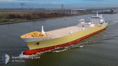
ORANGE SUN
Fruit Juice Tanker
Current Trip
| Time Travelled | 2 days |
|---|---|
| Remaining Time | --- |
| Distance Travelled | 991.45 морская миля |
| Remaining Distance | --- |
| AVG Speed | 14.6 Узлы |
| MAX Speed | 16.5 Узлы |
| AVG Wind | 9.5 knots |
| MAX Wind | 14.8 knots |
| MIN Temp | 22.2°C / 71.96°F |
| MAX Temp | 28.5°C / 83.3°F |
| Осадка | 9.9 м |
| Позиция Получена | 2 d тому назад |
Current Position
| Долгота | -42.38712° |
|---|---|
| Широта | -23.90018° |
| Статус | Under way using engine |
| Скорость | 15.6 Узлы |
| Курс | 87.3° |
| Район | South Atlantic Ocean |
| Станция | T-AIS |
| Позиция Получена | 2 d тому назад |
Info
Information
The current position of ORANGE SUN is in South Atlantic Ocean with coordinates -23.90018° / -42.38712° as reported on 2024-04-23 17:40 by AIS to our vessel tracker app. The vessel's current speed is 15.6 Узлы and is heading at the port of ROTTERDAM. The estimated time of arrival as calculated by MyShipTracking vessel tracking app is 2024-05-07 03:00 LT
The vessel ORANGE SUN (IMO: 9342580, MMSI: 636012804) is a Fruit Juice Tanker that was built in 2007 ( 17 лет ). It's sailing under the flag of [LR] Liberia.
In this page you can find informations about the vessels current position, last detected port calls, and current voyage information. If the vessels is not in coverage by AIS you will find the latest position.
The current position of ORANGE SUN is detected by our AIS receivers and we are not responsible for the reliability of the data. The last position was recorded while the vessel was in Coverage by the Ais receivers of our vessel tracking app.
The current draught of ORANGE SUN as reported by AIS is 9.9 meters
Weather
| Temperature | 28.1°C / 82.58°F |
|---|---|
| Wind Speed | 9 knots |
| Direction | 58° ENE |
| Pressure | 1011.6 hPa |
| Humidity | 77.1 % |
| Cloud Coverage | 12 % |
Featured Company
Most Visited Ports (Last year)
| Port | Arrivals | |
|---|---|---|
| 9 | ||
| 5 | ||
| 3 | ||
| 1 | ||
| 1 |
Last Trips
| Origin | Departure | Destination | Arrival | Distance | |
|---|---|---|---|---|---|
| 2024-04-05 08:49 | 2024-04-19 22:37 | 5501.42 морская миля | |||
| 2024-03-15 23:18 | 2024-03-31 07:50 | 5430.74 морская миля | |||
| 2024-02-25 13:07 | 2024-03-11 04:08 | 5027.08 морская миля | |||
| 2024-02-03 23:31 | 2024-02-17 13:08 | 5069.92 морская миля |
Events
| Время | Событие | Детали | Позиция / Направление | Информация |
|---|---|---|---|---|
| 2024-04-23 17:48 | Статус изменился | Default Under way using engine |
-23.89838 / -42.34894
NLRTM
|
Скорость: 15.6 kn Курс: 87.3° |
| 2024-04-23 17:40 | Вне покрытия |
-23.90018 / -42.38712
South Atlantic Ocean
NLRTM
|
Скорость: 15.6 kn Курс: 87.3° |
|
| 2024-04-23 17:39 | Статус изменился | Under way using engine Default |
-23.90032 / -42.39044
NLRTM
|
Скорость: 15.5 kn Курс: 87° |
| 2024-04-23 17:33 | Статус изменился | Default Under way using engine |
-23.90164 / -42.41915
NLRTM
|
Скорость: 15.7 kn Курс: 87.3° |
| 2024-04-23 17:24 | Статус изменился | Under way using engine Default |
-23.90329 / -42.45960
NLRTM
|
Скорость: 15.8 kn Курс: 87° |
| 2024-04-23 17:24 | В покрытии |
-23.90315 / -42.45523
South Atlantic Ocean
NLRTM
|
Скорость: 15.7 kn Курс: 88.1° |
|
| 2024-04-23 10:51 | Начало движения |
-24.02414 / -44.28156
NLRTM
|
Скорость: 7.7 kn Курс: 85° |
|
| 2024-04-23 09:00 | Окончание движения |
-24.02030 / -44.28521
NLRTM
|
Скорость: 0.3 kn Курс: 318° |
|
| 2024-04-22 21:12 | Статус изменился | Default Under way using engine |
-24.01545 / -46.34036
NLRTM
|
Скорость: 7.6 kn Курс: 203.1° |
| 2024-04-22 21:07 | Вне покрытия |
-24.00557 / -46.33619
South Atlantic Ocean
NLRTM
|
Скорость: 7.6 kn Курс: 203.1° |