
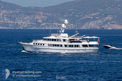
LADY GEORGINA
Yacht
Current Trip
| Trip Time | 1 day |
|---|---|
| Trip Distance | 460.48 морская миля |
| AVG Speed | 11.8 Узлы |
| MAX Speed | 14.3 Узлы |
| Осадка | 2.9 м |
| AVG Wind | 14.1 knots |
| MAX Wind | 18.1 knots |
| MIN Temp | 14.7°C / 58.46°F |
| MAX Temp | 17.2°C / 62.96°F |
| Позиция Получена | 1 m тому назад |
Current Position
| Долгота | 2.64023° |
|---|---|
| Широта | 39.56497° |
| Статус | Moored |
| Скорость | |
| Курс | 326° |
| Район | Balearic Sea |
| Станция | T-AIS |
| Позиция Получена | 1 m тому назад |
Info
Information
The current position of LADY GEORGINA is in Balearic Sea with coordinates 39.56497° / 2.64023° as reported on 2024-04-19 21:01 by AIS to our vessel tracker app. The vessel's current speed is 0 Узлы and is currently inside the port of PALMA DE MALLORCA.
The vessel LADY GEORGINA (IMO: 1002275, MMSI: 232205000) is a Yacht that was built in 1982 ( 42 лет ). It's sailing under the flag of [GB] United Kingdom.
In this page you can find informations about the vessels current position, last detected port calls, and current voyage information. If the vessels is not in coverage by AIS you will find the latest position.
The current position of LADY GEORGINA is detected by our AIS receivers and we are not responsible for the reliability of the data. The last position was recorded while the vessel was in Coverage by the Ais receivers of our vessel tracking app.
The current draught of LADY GEORGINA as reported by AIS is 2.9 meters
Weather
| Temperature | 11.7°C / 53.06°F |
|---|---|
| Wind Speed | 6 knots |
| Direction | 214° SW |
| Pressure | 1020.7 hPa |
| Humidity | 64.2 % |
| Cloud Coverage | --- |
Featured Company
Last Port Calls
| Port | Arrival | Departure | Time In Port |
|---|---|---|---|
| 2024-04-11 13:43 | |||
| 2024-04-09 20:16 | 2024-04-09 23:54 | 3 h | |
| 2024-03-27 20:55 | 2024-03-29 15:43 | 1 d |
Most Visited Ports (Last year)
| Port | Arrivals | |
|---|---|---|
| 5 | ||
| 4 | ||
| 4 | ||
| 2 | ||
| 2 | ||
| 1 |
Last Trips
| Origin | Departure | Destination | Arrival | Distance | |
|---|---|---|---|---|---|
| 2024-04-10 01:54 | 2024-04-11 15:43 | 460.48 морская миля | |||
| 2024-03-29 11:43 | 2024-04-09 22:16 | 3204.19 морская миля | |||
| 2024-01-10 16:03 | 2024-03-27 16:55 | 2236.42 морская миля |
Events
| Время | Событие | Детали | Позиция / Направление | Информация |
|---|---|---|---|---|
| 2024-04-12 05:21 | Статус изменился | Moored Under way using engine |
39.56602 / 2.64082
[ES] PALMA DE MALLORCA
|
Скорость: Курс: 236° |
| 2024-04-11 13:54 | Окончание движения |
39.56491 / 2.63688
[ES] PALMA DE MALLORCA
|
Скорость: 0.2 kn Курс: 123° |
|
| 2024-04-11 13:43 | Порт |
|
39.55423 / 2.64142
[ES] PALMA DE MALLORCA
|
Скорость: 12 kn Курс: 313.6° |
| 2024-04-11 12:07 | ETA изменился | 2024/04/11 16:00 2024/04/10 16:00 |
39.33851 / 2.34271
PALMA MALLORCA
|
Скорость: 12.3 kn Курс: 54.7° |
| 2024-04-11 11:53 | Изменение морского района | Spanish part of the Balearic Sea Spanish part of the Mediterranean Sea - Western Basin |
39.31025 / 2.29410
Balearic Sea
|
Скорость: 12.6 kn Курс: 48.6° |
| 2024-04-11 11:51 | В покрытии |
39.31025 / 2.29410
Balearic Sea
|
Скорость: 12.6 kn Курс: 48.6° |
|
| 2024-04-11 01:43 | Вне покрытия |
38.03020 / .25617
Mediterranean Sea - Western Basin
|
Скорость: 12.1 kn Курс: 53.9° |
|
| 2024-04-10 23:25 | В покрытии |
37.72222 / -.18850
Mediterranean Sea - Western Basin
|
Скорость: 12.6 kn Курс: 50° |
|
| 2024-04-10 22:18 | Вне покрытия |
37.56641 / -.40786
Mediterranean Sea - Western Basin
|
Скорость: 11.9 kn Курс: 42° |
|
| 2024-04-10 19:17 | В покрытии |
37.14064 / -1.02933
Mediterranean Sea - Western Basin
PALMA MALLORCA
|
Скорость: 12.4 kn Курс: 49.5° |