
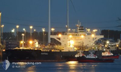
KAPSALI
Crude Oil Tanker
Current Trip
| Time Travelled | 4 days |
|---|---|
| Remaining Time | 2 h, 48 mins |
| Distance Travelled | 343.56 морская миля |
| Remaining Distance | 13.37 морская миля |
| AVG Speed | 8.1 Узлы |
| MAX Speed | 14.2 Узлы |
| AVG Wind | 6.8 knots |
| MAX Wind | 20.8 knots |
| MIN Temp | 14.4°C / 57.92°F |
| MAX Temp | 26.9°C / 80.42°F |
| Осадка | 9 м |
| Позиция Получена | Сейчас |
Current Position
| Долгота | 28.84332° |
|---|---|
| Широта | 40.81526° |
| Статус | Under way using engine |
| Скорость | 1 Узлы |
| Курс | 294° |
| Район | Sea of Marmara |
| Станция | T-AIS |
| Позиция Получена | Сейчас |
Info
Information
The current position of KAPSALI is in Sea of Marmara with coordinates 40.81526° / 28.84332° as reported on 2024-04-16 21:33 by AIS to our vessel tracker app. The vessel's current speed is 1 Узлы and is heading at the port of ISTANBUL. The estimated time of arrival as calculated by MyShipTracking vessel tracking app is 2024-04-17 00:22 LT
The vessel KAPSALI (IMO: 9587312, MMSI: 538008333) is a Crude Oil Tanker that was built in 2011 ( 13 лет ). It's sailing under the flag of [MH] Marshall Is.
In this page you can find informations about the vessels current position, last detected port calls, and current voyage information. If the vessels is not in coverage by AIS you will find the latest position.
The current position of KAPSALI is detected by our AIS receivers and we are not responsible for the reliability of the data. The last position was recorded while the vessel was in Coverage by the Ais receivers of our vessel tracking app.
The current draught of KAPSALI as reported by AIS is 9 meters
Weather
| Temperature | 16.3°C / 61.34°F |
|---|---|
| Wind Speed | 12 knots |
| Direction | 197° SSW |
| Pressure | 1007.2 hPa |
| Humidity | 61.7 % |
| Cloud Coverage | 100 % |
Featured Company
Last Port Calls
| Port | Arrival | Departure | Time In Port |
|---|---|---|---|
| 2024-04-11 10:58 | 2024-04-12 21:28 | 1 d | |
| 2024-03-15 22:57 | 2024-03-20 08:26 | 4 d | |
| 2024-03-09 03:06 | 2024-03-09 10:17 | 7 h |
Most Visited Ports (Last year)
| Port | Arrivals | |
|---|---|---|
| 3 | ||
| 1 | ||
| 1 | ||
| 1 | ||
| 1 | ||
| 1 |
Last Trips
| Origin | Departure | Destination | Arrival | Distance | |
|---|---|---|---|---|---|
| 2024-03-20 09:26 | 2024-04-11 13:58 | 3791.74 морская миля | |||
| 2024-03-09 10:17 | 2024-03-15 23:57 | 1781.54 морская миля | |||
| 2024-01-29 17:20 | 2024-03-09 03:06 | 5499.85 морская миля |
Events
| Время | Событие | Детали | Позиция / Направление | Информация |
|---|---|---|---|---|
| 2024-04-16 20:47 | Начало движения | 10 nm, South of YESILKOY |
40.79197 / 28.86917
BOSPORUS
|
Скорость: 3.1 kn Курс: 298° |
| 2024-04-16 17:47 | Окончание движения | 10.14 nm, South of YESILKOY |
40.79480 / 28.89544
BOSPORUS
|
Скорость: 0.3 kn Курс: 257° |
| 2024-04-16 15:52 | Начало движения | 11.85 nm, South West of MALTEPE |
40.77590 / 28.94387
BOSPORUS
|
Скорость: 3.1 kn Курс: 320° |
| 2024-04-16 15:34 | Окончание движения | 11.9 nm, South West of MALTEPE |
40.77283 / 28.94641
BOSPORUS
|
Скорость: 0.3 kn Курс: 33° |
| 2024-04-16 10:25 | Начало движения | 8.14 nm, South of YESILKOY |
40.82816 / 28.88828
BOSPORUS
|
Скорость: 3.1 kn Курс: 111° |
| 2024-04-16 07:39 | Окончание движения | 8.75 nm, South of YESILKOY |
40.81814 / 28.89116
BOSPORUS
|
Скорость: 0.3 kn Курс: 348° |
| 2024-04-16 06:32 | Начало движения | 10.04 nm, South of YESILKOY |
40.79373 / 28.88319
BOSPORUS
|
Скорость: 3.1 kn Курс: 33° |
| 2024-04-16 01:59 | Окончание движения | 8.94 nm, South of YESILKOY |
40.81210 / 28.87982
BOSPORUS
|
Скорость: 0.3 kn Курс: 181° |
| 2024-04-15 16:51 | Пункт назначения изменился | BOSPORUS KUMKALE |
40.61925 / 27.32724
BOSPORUS
|
Скорость: 10.5 kn Курс: 64.7° |
| 2024-04-15 16:51 | ETA изменился | 2024/04/16 00:01 2024/04/15 11:00 |
40.61925 / 27.32724
BOSPORUS
|
Скорость: 10.5 kn Курс: 64.7° |