
ISOLDANA
General Cargo
Current Trip
| Time Travelled | 36 days |
|---|---|
| Remaining Time | --- |
| Distance Travelled | 9982.84 морская миля |
| Remaining Distance | --- |
| AVG Speed | 12.5 Узлы |
| MAX Speed | 16.3 Узлы |
| AVG Wind | 11.7 knots |
| MAX Wind | 31.8 knots |
| MIN Temp | 7.1°C / 44.78°F |
| MAX Temp | 28.5°C / 83.3°F |
| Осадка | 7.9 м |
| Позиция Получена | 4 d тому назад |
Current Position
| Долгота | --- |
|---|---|
| Широта | --- |
| Статус | Under way using engine |
| Скорость | 12.6 Узлы |
| Курс | 287.7° |
| Район | South Atlantic Ocean |
| Станция | T-AIS |
| Позиция Получена | 4 d тому назад |
Info
Information
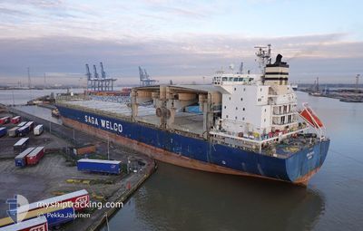
The current position of ISOLDANA is in South Atlantic Ocean with coordinates -34.10521° / 15.72162° as reported on 2025-12-04 12:59 by AIS to our vessel tracker app. The vessel's current speed is 12.6 Узлы and is heading at the port of NUEVA PALMIRA. The estimated time of arrival as calculated by MyShipTracking vessel tracking app is 2025-12-18 09:00 LT
The vessel ISOLDANA (IMO: 9186235, MMSI: 257091890) is a General Cargo that was built in 2000 ( 25 лет ). It's sailing under the flag of [NO] Norway.
In this page you can find informations about the vessels current position, last detected port calls, and current voyage information. If the vessels is not in coverage by AIS you will find the latest position.
The current position of ISOLDANA is detected by our AIS receivers and we are not responsible for the reliability of the data. The last position was recorded while the vessel was in Coverage by the Ais receivers of our vessel tracking app.
The current draught of ISOLDANA as reported by AIS is 7.9 meters
Weather
| Temperature | 22°C / 71.6°F |
|---|---|
| Wind Speed | 9 knots |
| Direction | 1° N |
| Pressure | 1020.9 hPa |
| Humidity | 64.6 % |
| Cloud Coverage | 38 % |
Featured Company
Most Visited Ports (Last year)
| Port | Arrivals | |
|---|---|---|
| 2 | ||
| 2 | ||
| 2 | ||
| 2 | ||
| 2 | ||
| 2 |
Last Trips
| Origin | Departure | Destination | Arrival | Distance | |
|---|---|---|---|---|---|
| 2025-10-30 16:41 | 2025-11-01 16:33 | 551.72 морская миля | |||
| 2025-10-27 08:24 | 2025-10-29 16:32 | 569.14 морская миля | |||
| 2025-10-21 10:16 | 2025-10-26 13:16 | 728.90 морская миля | |||
| 2025-09-29 14:41 | 2025-10-18 14:22 | 5261.25 морская миля |
Events
| Время | Событие | Детали | Позиция / Направление | Информация |
|---|---|---|---|---|
| 2025-12-04 13:00 | Статус изменился | Default Under way using engine |
-34.10386 / 15.71684
UYNVP
|
Скорость: 12.6 kn Курс: 287.7° |
| 2025-12-04 12:59 | Статус изменился | Under way using engine Default |
-34.10521 / 15.72162
UYNVP
|
Скорость: 12.9 kn Курс: 287° |
| 2025-12-04 12:59 | Вне покрытия |
-34.10521 / 15.72162
South Atlantic Ocean
UYNVP
|
Скорость: 12.6 kn Курс: 287.7° |
|
| 2025-12-04 12:28 | Статус изменился | Default Under way using engine |
-34.13529 / 15.84813
UYNVP
|
Скорость: 12.4 kn Курс: 282.7° |
| 2025-12-04 12:28 | Статус изменился | Under way using engine Default |
-34.13541 / 15.84867
UYNVP
|
Скорость: 12.4 kn Курс: 282° |
| 2025-12-04 12:16 | В покрытии |
-34.13541 / 15.84867
South Atlantic Ocean
UYNVP
|
Скорость: 12.4 kn Курс: 282.7° |
|
| 2025-12-04 10:08 | Статус изменился | Default Under way using engine |
-34.25642 / 16.38936
UYNVP
|
Скорость: 11.9 kn Курс: 287.9° |
| 2025-12-04 10:00 | Вне покрытия |
-34.26409 / 16.41763
South Atlantic Ocean
UYNVP
|
Скорость: 11.9 kn Курс: 287.9° |
|
| 2025-12-04 09:56 | Статус изменился | Under way using engine Default |
-34.26900 / 16.43544
UYNVP
|
Скорость: 11.9 kn Курс: 288° |
| 2025-12-04 09:40 | В покрытии |
-34.26828 / 16.43290
South Atlantic Ocean
UYNVP
|
Скорость: 12 kn Курс: 288.2° |