
FRIEDERIKE
Cargo
Current Trip
| Time Travelled | 12 days |
|---|---|
| Remaining Time | 17 h, 49 mins |
| Distance Travelled | 3045.81 морская миля |
| Remaining Distance | 199.39 морская миля |
| AVG Speed | 10.6 Узлы |
| MAX Speed | 13.2 Узлы |
| AVG Wind | 15.6 knots |
| MAX Wind | 51 knots |
| MIN Temp | 8.2°C / 46.76°F |
| MAX Temp | 23.2°C / 73.76°F |
| Осадка | 10.6 м |
| Позиция Получена | 1 m тому назад |
Current Position
| Долгота | 25.12742° |
|---|---|
| Широта | 38.82128° |
| Статус | Under way using engine |
| Скорость | 11.1 Узлы |
| Курс | 23° |
| Район | Aegean Sea |
| Станция | T-AIS |
| Позиция Получена | 1 m тому назад |
Info
Information
The current position of FRIEDERIKE is in Aegean Sea with coordinates 38.82128° / 25.12742° as reported on 2024-04-19 06:09 by AIS to our vessel tracker app. The vessel's current speed is 11.1 Узлы and is heading at the port of MARTAS. The estimated time of arrival as calculated by MyShipTracking vessel tracking app is 2024-04-20 00:00 LT
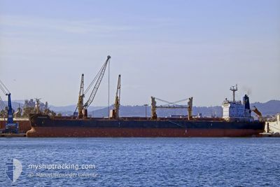
The vessel FRIEDERIKE (IMO: 9436769, MMSI: 538004370) is a Cargo It's sailing under the flag of [MH] Marshall Is.
In this page you can find informations about the vessels current position, last detected port calls, and current voyage information. If the vessels is not in coverage by AIS you will find the latest position.
The current position of FRIEDERIKE is detected by our AIS receivers and we are not responsible for the reliability of the data. The last position was recorded while the vessel was in Coverage by the Ais receivers of our vessel tracking app.
The current draught of FRIEDERIKE as reported by AIS is 10.6 meters
Weather
| Temperature | 16.9°C / 62.42°F |
|---|---|
| Wind Speed | 10 knots |
| Direction | 347° NNW |
| Pressure | 1010.3 hPa |
| Humidity | 70.1 % |
| Cloud Coverage | 55 % |
Featured Company
Last Port Calls
| Port | Arrival | Departure | Time In Port |
|---|---|---|---|
| 2024-04-01 08:45 | 2024-04-06 15:05 | 5 d | |
| 2024-03-13 04:23 | 2024-03-20 17:47 | 7 d | |
| 2024-02-01 00:00 |
Most Visited Ports (Last year)
| Port | Arrivals | |
|---|---|---|
| 3 | ||
| 2 | ||
| 2 | ||
| 1 | ||
| 1 | ||
| 1 |
Last Trips
| Origin | Departure | Destination | Arrival | Distance | |
|---|---|---|---|---|---|
| 2024-03-20 18:47 | 2024-04-01 10:45 | 233.19 морская миля | |||
| 2024-01-31 18:00 | 2024-03-13 05:23 | 6014.54 морская миля |
Events
| Время | Событие | Детали | Позиция / Направление | Информация |
|---|---|---|---|---|
| 2024-04-19 05:00 | В покрытии |
38.62878 / 25.01182
Aegean Sea
|
Скорость: 11.2 kn Курс: 23° |
|
| 2024-04-19 00:47 | Вне покрытия |
37.93833 / 24.60975
Aegean Sea
|
Скорость: 10.7 kn Курс: 40° |
|
| 2024-04-18 14:14 | Изменение морского района | Greek part of the Aegean Sea Greek part of the Mediterranean Sea - Eastern Basin |
36.39046 / 23.17741
Aegean Sea
|
Скорость: 12 kn Курс: 77° |
| 2024-04-18 13:18 | Статус изменился | Under way using engine Default |
36.42105 / 22.96423
MARTAS,TURKEY
|
Скорость: 11.5 kn Курс: 83° |
| 2024-04-18 13:08 | Статус изменился | Default Under way using engine |
36.41742 / 22.92317
MARTAS,TURKEY
|
Скорость: 11.8 kn Курс: 76° |
| 2024-04-18 10:55 | Обнаружено в море | Greek part of the Mediterranean Sea - Eastern Basin |
36.33537 / 22.40357
Mediterranean Sea - Eastern Basin
MARTAS,TURKEY
|
Скорость: 11.2 kn Курс: 86° |
| 2024-04-18 10:55 | В покрытии |
36.33537 / 22.40357
Mediterranean Sea - Eastern Basin
MARTAS,TURKEY
|
Скорость: 11.2 kn Курс: 86° |
|
| 2024-04-17 01:27 | Статус изменился | Default Under way using engine |
36.16620 / 14.60925
MARTAS,TURKEY
|
Скорость: 11.6 kn Курс: 88° |
| 2024-04-17 01:21 | Вне покрытия |
36.16588 / 14.58517
Mediterranean Sea - Eastern Basin
MARTAS,TURKEY
|
Скорость: 11.6 kn Курс: 88° |
|
| 2024-04-16 21:44 | Статус изменился | Under way using engine Default |
36.41957 / 13.79298
MARTAS,TURKEY
|
Скорость: 11.5 kn Курс: 113° |