
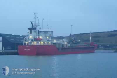
FRAKT FJORD
General Cargo
Current Trip
| Time Travelled | 1 day |
|---|---|
| Remaining Time | 4 h, 4 mins |
| Distance Travelled | 226.59 морская миля |
| Remaining Distance | 51.15 морская миля |
| AVG Speed | 11.4 Узлы |
| MAX Speed | 14.4 Узлы |
| AVG Wind | 9.6 knots |
| MAX Wind | 19 knots |
| MIN Temp | 2.4°C / 36.32°F |
| MAX Temp | 9°C / 48.2°F |
| Осадка | 6.2 м |
| Позиция Получена | 1 m тому назад |
Current Position
| Долгота | 5.85719° |
|---|---|
| Широта | 58.41100° |
| Статус | Under way using engine |
| Скорость | 11.8 Узлы |
| Курс | 313° |
| Район | North Sea |
| Станция | T-AIS |
| Позиция Получена | 1 m тому назад |
Info
Information
The current position of FRAKT FJORD is in North Sea with coordinates 58.41100° / 5.85719° as reported on 2024-04-18 06:11 by AIS to our vessel tracker app. The vessel's current speed is 11.8 Узлы and is heading at the port of STAVANGER. The estimated time of arrival as calculated by MyShipTracking vessel tracking app is 2024-04-18 10:16 LT
The vessel FRAKT FJORD (IMO: 9356581, MMSI: 212530000) is a General Cargo that was built in 2008 ( 16 лет ). It's sailing under the flag of [CY] Cyprus.
In this page you can find informations about the vessels current position, last detected port calls, and current voyage information. If the vessels is not in coverage by AIS you will find the latest position.
The current position of FRAKT FJORD is detected by our AIS receivers and we are not responsible for the reliability of the data. The last position was recorded while the vessel was in Coverage by the Ais receivers of our vessel tracking app.
The current draught of FRAKT FJORD as reported by AIS is 6.2 meters
Weather
| Temperature | 5.6°C / 42.08°F |
|---|---|
| Wind Speed | 4 knots |
| Direction | 216° SW |
| Pressure | 1015.6 hPa |
| Humidity | 72.1 % |
| Cloud Coverage | 73 % |
Featured Company
Last Port Calls
| Port | Arrival | Departure | Time In Port |
|---|---|---|---|
| 2024-04-15 22:33 | 2024-04-16 13:42 | 15 h | |
| 2024-04-15 04:11 | 2024-04-15 20:24 | 16 h | |
| 2024-04-10 13:31 | 2024-04-11 13:54 | 1 d | |
| 2024-04-07 08:40 | 2024-04-09 13:03 | 2 d | |
| 2024-04-04 21:30 | 2024-04-06 04:19 | 1 d | |
| 2024-03-30 23:52 | 2024-04-03 22:32 | 3 d | |
| 2024-03-25 05:26 | 2024-03-27 16:52 | 2 d | |
| 2024-03-24 02:48 | 2024-03-24 18:33 | 15 h | |
| 2024-03-17 13:07 | 2024-03-18 23:32 | 1 d | |
| 2024-03-16 10:46 | 2024-03-17 07:56 | 21 h |
Last Trips
| Origin | Departure | Destination | Arrival | Distance | |
|---|---|---|---|---|---|
| 2024-04-15 22:24 | 2024-04-16 00:33 | 25.34 морская миля | |||
| 2024-04-11 15:54 | 2024-04-15 06:11 | 888.38 морская миля | |||
| 2024-04-09 15:03 | 2024-04-10 15:31 | 307.22 морская миля | |||
| 2024-04-06 06:19 | 2024-04-07 10:40 | 312.48 морская миля | |||
| 2024-04-04 00:32 | 2024-04-04 23:30 | 280.00 морская миля | |||
| 2024-03-27 17:52 | 2024-03-31 00:52 | 845.85 морская миля | |||
| 2024-03-24 19:33 | 2024-03-25 06:26 | 88.20 морская миля | |||
| 2024-03-19 00:32 | 2024-03-24 03:48 | 682.56 морская миля | |||
| 2024-03-17 08:56 | 2024-03-17 14:07 | 56.62 морская миля | |||
| 2024-03-12 18:45 | 2024-03-16 11:46 | 903.26 морская миля |
Events
| Время | Событие | Детали | Позиция / Направление | Информация |
|---|---|---|---|---|
| 2024-04-18 04:08 | ETA изменился | 2024/04/18 12:00 2024/04/18 15:00 |
58.14003 / 6.42345
STAVANGER EAST
|
Скорость: 12.2 kn Курс: 312° |
| 2024-04-18 02:15 | Обнаружено в море | Norwegian part of the North Sea |
57.96640 / 7.04141
North Sea
STAVANGER EAST
|
Скорость: 12.2 kn Курс: 288° |
| 2024-04-17 13:32 | Начало движения | 0.76 nm, South East of HOLMESTRAND |
59.48005 / 10.33437
STAVANGER EAST
|
Скорость: 3.9 kn Курс: 55° |
| 2024-04-17 13:17 | Статус изменился | Under way using engine Moored |
59.47833 / 10.33248
STAVANGER EAST
|
Скорость: Курс: 3° |
| 2024-04-16 15:39 | Осадка изменилась | 6.2 5.2 |
59.47827 / 10.33248
STAVANGER EAST
|
Скорость: 0.1 kn Курс: 2° |
| 2024-04-16 15:39 | Пункт назначения изменился | STAVANGER EAST HOLMESTRAND |
59.47827 / 10.33248
STAVANGER EAST
|
Скорость: 0.1 kn Курс: 2° |
| 2024-04-16 15:39 | ETA изменился | 2024/04/18 15:00 2025/03/21 12:34 |
59.47827 / 10.33248
STAVANGER EAST
|
Скорость: 0.1 kn Курс: 2° |
| 2024-04-16 15:19 | Статус изменился | Moored Under way using engine |
59.47827 / 10.33247
HOLMESTRAND
|
Скорость: Курс: 2° |
| 2024-04-16 15:13 | Окончание движения | 0.84 nm, South East of HOLMESTRAND |
59.47828 / 10.33304
HOLMESTRAND
|
Скорость: 0.2 kn Курс: 330° |
| 2024-04-16 13:42 | ПОРТ ОТПРАВЛЕНИЯ |
|
59.72547 / 10.27117
HOLMESTRAND
|
Скорость: 12.8 kn Курс: 127° |