
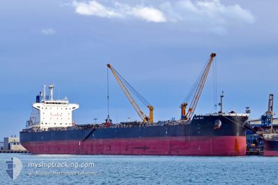
FLAG EVI
Bulk Carrier
Current Trip
IN SAL
| Time Travelled | 42 days |
|---|---|
| Remaining Time | --- |
| Distance Travelled | 3653.75 морская миля |
| Remaining Distance | --- |
| AVG Speed | 10.8 Узлы |
| MAX Speed | 15.1 Узлы |
| AVG Wind | 9 knots |
| MAX Wind | 28 knots |
| MIN Temp | 8.2°C / 46.76°F |
| MAX Temp | 30.6°C / 87.08°F |
| Осадка | 14.6 м |
| Позиция Получена | 1 m тому назад |
Current Position
| Долгота | 103.94274° |
|---|---|
| Широта | 1.28359° |
| Статус | At anchor |
| Скорость | |
| Курс | 68° |
| Район | Singapore Strait |
| Станция | T-AIS |
| Позиция Получена | 1 m тому назад |
Info
Information
The current position of FLAG EVI is in Singapore Strait with coordinates 1.28359° / 103.94274° as reported on 2024-04-25 07:35 by AIS to our vessel tracker app. The vessel's current speed is 0 Узлы
The vessel FLAG EVI (IMO: 9619799, MMSI: 373562000) is a Bulk Carrier that was built in 2014 ( 10 лет ). It's sailing under the flag of [PA] Panama.
In this page you can find informations about the vessels current position, last detected port calls, and current voyage information. If the vessels is not in coverage by AIS you will find the latest position.
The current position of FLAG EVI is detected by our AIS receivers and we are not responsible for the reliability of the data. The last position was recorded while the vessel was in Coverage by the Ais receivers of our vessel tracking app.
The current draught of FLAG EVI as reported by AIS is 14.6 meters
Weather
| Temperature | 30.1°C / 86.18°F |
|---|---|
| Wind Speed | 7 knots |
| Direction | 68° ENE |
| Pressure | 1005.5 hPa |
| Humidity | 71.6 % |
| Cloud Coverage | 18 % |
Featured Company
Last Port Calls
| Port | Arrival | Departure | Time In Port |
|---|---|---|---|
| 2024-03-10 07:50 | 2024-03-13 23:02 | 3 d | |
| 2024-02-06 00:38 | 2024-02-07 12:54 | 1 d |
Last Trips
| Origin | Departure | Destination | Arrival | Distance | |
|---|---|---|---|---|---|
| 2024-02-07 20:54 | 2024-03-10 15:50 | 491.58 морская миля | |||
| 2024-01-13 14:24 | 2024-02-06 08:38 | 5282.37 морская миля |
Events
| Время | Событие | Детали | Позиция / Направление | Информация |
|---|---|---|---|---|
| 2024-04-25 04:17 | Осадка изменилась | 14.6 14.5 |
1.28383 / 103.94272
IN SAL
|
Скорость: 0.1 kn Курс: 79° |
| 2024-04-25 04:17 | Пункт назначения изменился | IN SAL SG SIN |
1.28383 / 103.94272
IN SAL
|
Скорость: 0.1 kn Курс: 79° |
| 2024-04-25 04:17 | ETA изменился | 2024/05/05 14:30 2024/04/25 01:00 |
1.28383 / 103.94272
IN SAL
|
Скорость: 0.1 kn Курс: 79° |
| 2024-04-25 02:14 | Окончание движения | 4.83 nm, West of TANAH MERAH |
1.28411 / 103.94252
SG SIN
|
Скорость: Курс: 81° |
| 2024-04-25 02:08 | Статус изменился | At anchor Under way using engine |
1.28403 / 103.94314
SG SIN
|
Скорость: 0.6 kn Курс: 72° |
| 2024-04-25 01:19 | Начало движения | 3.5 nm, South West of TANAH MERAH |
1.26900 / 103.97842
SG SIN
|
Скорость: 3.1 kn Курс: 299° |
| 2024-04-25 01:12 | Окончание движения | 3.66 nm, South West of TANAH MERAH |
1.26601 / 103.97780
SG SIN
|
Скорость: 0.3 kn Курс: 50° |
| 2024-04-25 00:41 | Изменение морского района | Singaporean part of the Singapore Strait Indonesian part of the Singapore Strait |
1.26217 / 104.01534
Singapore Strait
SG SIN
|
Скорость: 8.9 kn Курс: 262.4° |
| 2024-04-25 00:20 | Изменение морского района | Indonesian part of the Singapore Strait Malaysian part of the Singapore Strait |
1.27080 / 104.06559
Singapore Strait
SG SIN
|
Скорость: 9.5 kn Курс: 259.7° |
| 2024-04-24 23:02 | Осадка изменилась | 14.5 13.5 |
1.30133 / 104.27066
SG SIN
|
Скорость: 10.5 kn Курс: 263.3° |