
ADVENTUM
Cargo
Current Trip
HUIS
| Time Travelled | 18 h, 12 mins |
|---|---|
| Remaining Time | --- |
| Distance Travelled | 4.10 морская миля |
| Remaining Distance | --- |
| AVG Speed | 5.3 Узлы |
| MAX Speed | 6.4 Узлы |
| AVG Wind | 16 knots |
| MAX Wind | 16 knots |
| MIN Temp | 9°C / 48.2°F |
| MAX Temp | 9.2°C / 48.56°F |
| Осадка | 2.6 м |
| Позиция Получена | 1 m тому назад |
Current Position
| Долгота | 5.33008° |
|---|---|
| Широта | 51.74408° |
| Статус | Under way using engine |
| Скорость | |
| Курс | --- |
| Район | North Sea |
| Станция | T-AIS |
| Позиция Получена | 1 m тому назад |
Info
Information
The current position of ADVENTUM is in North Sea with coordinates 51.74408° / 5.33008° as reported on 2024-04-25 07:07 by AIS to our vessel tracker app. The vessel's current speed is 0 Узлы
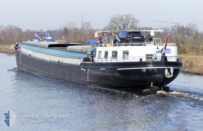
The vessel ADVENTUM (MMSI: 244710271) is a Cargo It's sailing under the flag of [NL] Netherlands.
In this page you can find informations about the vessels current position, last detected port calls, and current voyage information. If the vessels is not in coverage by AIS you will find the latest position.
The current position of ADVENTUM is detected by our AIS receivers and we are not responsible for the reliability of the data. The last position was recorded while the vessel was in Coverage by the Ais receivers of our vessel tracking app.
The current draught of ADVENTUM as reported by AIS is 2.6 meters
Weather
| Temperature | 6.3°C / 43.34°F |
|---|---|
| Wind Speed | 7 knots |
| Direction | 251° WSW |
| Pressure | 1006.7 hPa |
| Humidity | 79.4 % |
| Cloud Coverage | 100 % |
Featured Company
Last Port Calls
| Port | Arrival | Departure | Time In Port |
|---|---|---|---|
| 2024-04-19 17:54 | 2024-04-24 12:56 | 4 d | |
| 2024-04-19 15:45 | 2024-04-19 16:26 | 41 m | |
| 2024-04-19 04:44 | 2024-04-19 09:45 | 5 h | |
| 2024-04-15 08:35 | 2024-04-17 08:15 | 1 d | |
| 2024-04-12 17:18 | 2024-04-15 03:29 | 2 d | |
| 2024-04-11 10:49 | 2024-04-11 12:03 | 1 h | |
| 2024-04-09 23:49 | |||
| 2024-04-05 19:11 | 2024-04-06 06:08 | 10 h | |
| 2024-04-04 03:45 | 2024-04-04 04:31 | 46 m | |
| 2024-04-03 14:56 | 2024-04-03 16:02 | 1 h |
Last Trips
| Origin | Departure | Destination | Arrival | Distance | |
|---|---|---|---|---|---|
| 2024-04-19 18:26 | 2024-04-19 19:54 | 7.29 морская миля | |||
| 2024-04-19 11:45 | 2024-04-19 17:45 | 44.81 морская миля | |||
| 2024-04-17 10:15 | 2024-04-19 06:44 | 92.94 морская миля | |||
| 2024-04-15 05:29 | 2024-04-15 10:35 | 32.76 морская миля | |||
| 2024-04-11 14:03 | 2024-04-12 19:18 | 117.37 морская миля | |||
| 2024-04-10 01:49 | 2024-04-11 12:49 | 97.25 морская миля | |||
| 2024-04-04 06:31 | 2024-04-05 21:11 | 51.85 морская миля | |||
| 2024-04-03 18:02 | 2024-04-04 05:45 | 7.62 морская миля | |||
| 2024-04-02 16:24 | 2024-04-03 16:56 | 60.51 морская миля | |||
| 2024-04-01 18:25 | 2024-04-02 15:46 | 66.38 морская миля |
Events
| Время | Событие | Детали | Позиция / Направление | Информация |
|---|---|---|---|---|
| 2024-04-24 15:24 | Окончание движения | 1.74 nm, South West of KERKDRIEL |
51.74416 / 5.33012
HUIS
|
Скорость: 0.3 kn Курс: 511° |
| 2024-04-24 15:19 | Начало движения | 1.91 nm, South of KERKDRIEL |
51.74019 / 5.33323
HUIS
|
Скорость: 3.9 kn Курс: 337.1° |
| 2024-04-24 15:04 | Окончание движения | 1.99 nm, South of KERKDRIEL |
51.73834 / 5.33456
HUIS
|
Скорость: Курс: 0° |
| 2024-04-24 14:39 | Начало движения | 2.05 nm, East of S-HERTOGENBOSCH |
51.70030 / 5.35787
HUIS
|
Скорость: 5 kn Курс: 348.9° |
| 2024-04-24 14:26 | Окончание движения | 2.08 nm, East of S-HERTOGENBOSCH |
51.69850 / 5.35892
HUIS
|
Скорость: Курс: 511° |
| 2024-04-24 14:15 | Начало движения | 2.38 nm, East of S-HERTOGENBOSCH |
51.68856 / 5.36520
HUIS
|
Скорость: 6.2 kn Курс: 326.4° |
| 2024-04-24 14:14 | Окончание движения | 2.46 nm, East of S-HERTOGENBOSCH |
51.68701 / 5.36672
HUIS
|
Скорость: Курс: 0° |
| 2024-04-24 14:09 | В покрытии |
51.68207 / 5.37206
North Sea
|
Скорость: 5.9 kn Курс: 322.8° |
|
| 2024-04-24 12:56 | ПОРТ ОТПРАВЛЕНИЯ |
|
51.68207 / 5.37206
HUIS
|
Скорость: Курс: 511° |
| 2024-04-23 07:28 | Вне покрытия |
51.61472 / 5.53297
North Sea
[NL] VEGHEL
|
Скорость: Курс: 226.9° |