
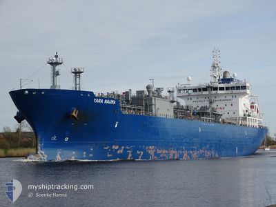
YARA NAUMA
Tanker D
Current Trip
| Time Travelled | 9 days |
|---|---|
| Remaining Time | --- |
| Distance Travelled | 2095.96 nm |
| Remaining Distance | 53.80 nm |
| AVG Speed | 12.6 Knopen |
| MAX Speed | 15.5 Knopen |
| AVG Wind | 16.3 knots |
| MAX Wind | 30 knots |
| MIN Temp | 1.8°C / 35.24°F |
| MAX Temp | 12.4°C / 54.32°F |
| Diepgang | 6.8 M |
| Positie ontvangen | 4 m geleden |
Current Position
| Lengtegraad | 2.58794° |
|---|---|
| Breedtegraat | 51.40411° |
| Status | At anchor |
| Snelheid | 0.3 Knopen |
| Koers | 234° |
| Gebied | North Sea |
| Station | T-AIS |
| Positie ontvangen | 4 m geleden |
Info
Information
The current position of YARA NAUMA is in North Sea with coordinates 51.40411° / 2.58794° as reported on 2024-04-18 22:57 by AIS to our vessel tracker app. The vessel's current speed is 0.3 Knopen and is heading at the port of SLUISKIL. The estimated time of arrival as calculated by MyShipTracking vessel tracking app is 2024-04-18 14:00 LT
The vessel YARA NAUMA (IMO: 9734848, MMSI: 258933000) is a Tanker D It's sailing under the flag of [NO] Norway.
In this page you can find informations about the vessels current position, last detected port calls, and current voyage information. If the vessels is not in coverage by AIS you will find the latest position.
The current position of YARA NAUMA is detected by our AIS receivers and we are not responsible for the reliability of the data. The last position was recorded while the vessel was in Coverage by the Ais receivers of our vessel tracking app.
The current draught of YARA NAUMA as reported by AIS is 6.8 meters
Weather
| Temperature | 8.7°C / 47.66°F |
|---|---|
| Wind Speed | 28 knots |
| Direction | 260° W |
| Pressure | 1018 hPa |
| Humidity | 72.4 % |
| Cloud Coverage | 100 % |
Featured Company
Last Trips
| Origin | Departure | Destination | Arrival | Distance | |
|---|---|---|---|---|---|
| 2024-04-09 05:09 | 2024-04-09 14:26 | 48.66 nm | |||
| 2024-04-08 06:54 | 2024-04-08 15:05 | 48.42 nm | |||
| 2024-02-28 06:53 | 2024-04-08 05:59 | 7415.45 nm | |||
| 2024-02-05 03:27 | 2024-02-27 09:41 | 4743.46 nm | |||
| 2024-01-31 06:40 | 2024-02-03 21:00 | 981.63 nm |
Events
| Tijd | Evenement | Details | Positie / Bestemming | Info |
|---|---|---|---|---|
| 2024-04-18 13:42 | Status Changed | At anchor Under way using engine |
51.40114 / 2.58419
NLSLU
|
Snelheid: 0.5 kn Koers: 0° |
| 2024-04-18 13:42 | Stop beweging | 17.1 nm, North West of OOSTENDE |
51.40114 / 2.58419
NLSLU
|
Snelheid: 0.2 kn Koers: 0° |
| 2024-04-18 10:53 | Wijzig zee gebeid | Belgian part of the North Sea Dutch part of the North Sea |
51.82562 / 2.60151
North Sea
NLSLU
|
Snelheid: 13.1 kn Koers: 178.9° |
| 2024-04-18 10:16 | ETA Changed | 2024/04/18 14:00 2024/04/18 15:00 |
51.95030 / 2.62860
NLSLU
|
Snelheid: 12.5 kn Koers: 180.4° |
| 2024-04-18 10:08 | Gevonden in zee | Dutch part of the North Sea |
51.97867 / 2.62869
North Sea
NLSLU
|
Snelheid: 13.7 kn Koers: 179.9° |
| 2024-04-18 09:13 | Binnenbereik |
52.18864 / 2.63439
North Sea
NLSLU
|
Snelheid: 13.6 kn Koers: 190.2° |
|
| 2024-04-18 08:00 | Status Changed | Default Under way using engine |
52.44140 / 2.85425
NLSLU
|
Snelheid: 14.5 kn Koers: 211.2° |
| 2024-04-18 07:56 | Gevonden in zee | United Kingdom part of the North Sea |
52.45584 / 2.86885
North Sea
NLSLU
|
Snelheid: 14.5 kn Koers: 211.2° |
| 2024-04-18 07:56 | Status Changed | Under way using engine Default |
52.45584 / 2.86885
NLSLU
|
Snelheid: 14.4 kn Koers: 209° |
| 2024-04-18 07:56 | Buitenbereik |
52.45584 / 2.86885
North Sea
NLSLU
|
Snelheid: 14.5 kn Koers: 211.2° |