
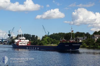
TORPO
General Cargo
Current Trip
| Time Travelled | 17 days |
|---|---|
| Remaining Time | 2 days |
| Distance Travelled | 2836.12 nm |
| Remaining Distance | 711.30 nm |
| AVG Speed | 7.4 Knopen |
| MAX Speed | 12.8 Knopen |
| AVG Wind | 18.5 knots |
| MAX Wind | 43.6 knots |
| MIN Temp | 5.8°C / 42.44°F |
| MAX Temp | 19.8°C / 67.64°F |
| Diepgang | 5.2 M |
| Positie ontvangen | 11 h, 18 m geleden |
Current Position
| Lengtegraad | 15.22938° |
|---|---|
| Breedtegraat | 36.56687° |
| Status | Under way using engine |
| Snelheid | 8.3 Knopen |
| Koers | 90.1° |
| Gebied | Mediterranean Sea - Eastern Basin |
| Station | T-AIS |
| Positie ontvangen | 11 h, 18 m geleden |
Info
Information
The current position of TORPO is in Mediterranean Sea - Eastern Basin with coordinates 36.56687° / 15.22938° as reported on 2024-04-19 17:45 by AIS to our vessel tracker app. The vessel's current speed is 8.3 Knopen and is heading at the port of NEA KARVALI. The estimated time of arrival as calculated by MyShipTracking vessel tracking app is 2024-04-23 00:12 LT
The vessel TORPO (IMO: 8908791, MMSI: 314419000) is a General Cargo that was built in 1990 ( 34 Jaar oud ). It's sailing under the flag of [BB] Barbados.
In this page you can find informations about the vessels current position, last detected port calls, and current voyage information. If the vessels is not in coverage by AIS you will find the latest position.
The current position of TORPO is detected by our AIS receivers and we are not responsible for the reliability of the data. The last position was recorded while the vessel was in Coverage by the Ais receivers of our vessel tracking app.
The current draught of TORPO as reported by AIS is 5.2 meters
Weather
| Temperature | 15.6°C / 60.08°F |
|---|---|
| Wind Speed | 19 knots |
| Direction | 330° NNW |
| Pressure | 1013.7 hPa |
| Humidity | 61.3 % |
| Cloud Coverage | --- |
Featured Company
Last Port Calls
| Port | Arrival | Departure | Time In Port |
|---|---|---|---|
| 2024-03-30 01:52 | 2024-04-02 13:37 | 3 d | |
| 2024-03-23 05:06 | 2024-03-23 17:33 | 12 h | |
| 2024-03-07 14:42 | 2024-03-07 16:49 | 2 h | |
| 2024-03-06 06:42 | 2024-03-06 23:52 | 17 h | |
| 2024-02-20 17:29 | 2024-02-22 17:34 | 2 d | |
| 2024-02-15 19:30 | 2024-02-17 14:38 | 1 d | |
| 2024-02-09 16:13 | 2024-02-12 14:15 | 2 d | |
| 2024-02-06 04:49 | 2024-02-08 10:10 | 2 d | |
| 2024-02-01 18:32 |
Last Trips
| Origin | Departure | Destination | Arrival | Distance | |
|---|---|---|---|---|---|
| 2024-03-23 18:33 | 2024-03-30 02:52 | 1086.14 nm | |||
| 2024-03-07 17:49 | 2024-03-23 06:06 | 2241.32 nm | |||
| 2024-03-07 00:52 | 2024-03-07 15:42 | 146.79 nm | |||
| 2024-02-22 18:34 | 2024-03-06 07:42 | 2260.21 nm | |||
| 2024-02-17 15:38 | 2024-02-20 18:29 | 247.72 nm | |||
| 2024-02-12 15:15 | 2024-02-15 20:30 | 659.16 nm | |||
| 2024-02-08 11:10 | 2024-02-09 17:13 | 252.64 nm | |||
| 2024-02-01 19:32 | 2024-02-06 05:49 | 969.78 nm |
Events
| Tijd | Evenement | Details | Positie / Bestemming | Info |
|---|---|---|---|---|
| 2024-04-19 17:47 | Status Changed | Default Under way using engine |
36.56689 / 15.23226
GR NKV
|
Snelheid: 8.3 kn Koers: 90.1° |
| 2024-04-19 17:45 | Buitenbereik |
36.56687 / 15.22938
Mediterranean Sea - Eastern Basin
GR NKV
|
Snelheid: 8.3 kn Koers: 90.1° |
|
| 2024-04-19 17:11 | Status Changed | Under way using engine Default |
36.56972 / 15.13188
GR NKV
|
Snelheid: 8.7 kn Koers: 97° |
| 2024-04-19 17:11 | Binnenbereik |
36.56962 / 15.13425
Mediterranean Sea - Eastern Basin
GR NKV
|
Snelheid: 8.3 kn Koers: 92.8° |
|
| 2024-04-19 16:15 | Status Changed | Default Under way using engine |
36.57871 / 14.96541
GR NKV
|
Snelheid: 9 kn Koers: 95.1° |
| 2024-04-19 16:03 | Buitenbereik |
36.58138 / 14.92847
Mediterranean Sea - Eastern Basin
GR NKV
|
Snelheid: 9 kn Koers: 95.1° |
|
| 2024-04-19 11:53 | Draught Changed | 5.2 5 |
36.72071 / 14.14586
GR NKV
|
Snelheid: 9.2 kn Koers: 118.5° |
| 2024-04-19 11:53 | ETA Changed | 2024/04/22 17:00 |
36.72071 / 14.14586
GR NKV
|
Snelheid: 9.2 kn Koers: 118.5° |
| 2024-04-19 11:12 | Wijzig zee gebeid | Italian part of the Mediterranean Sea - Eastern Basin Algerian part of the Mediterranean Sea - Western Basin |
36.76915 / 14.03309
Mediterranean Sea - Eastern Basin
|
Snelheid: 9 kn Koers: 118.2° |
| 2024-04-19 11:11 | Binnenbereik |
36.76915 / 14.03309
Mediterranean Sea - Eastern Basin
|
Snelheid: 9 kn Koers: 118.2° |