
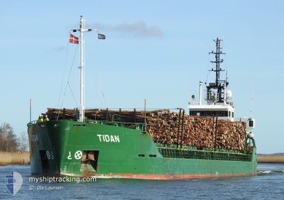
TIDAN
General Cargo
Current Trip
| Time Travelled | 2 days |
|---|---|
| Remaining Time | 20 h, 5 mins |
| Distance Travelled | 452.28 nm |
| Remaining Distance | 218.69 nm |
| AVG Speed | 9.4 Knopen |
| MAX Speed | 11.2 Knopen |
| AVG Wind | 11.6 knots |
| MAX Wind | 28.2 knots |
| MIN Temp | -1.8°C / 28.76°F |
| MAX Temp | 3.1°C / 37.58°F |
| Diepgang | 3.7 M |
| Positie ontvangen | 29 m geleden |
Current Position
| Lengtegraad | 19.86012° |
|---|---|
| Breedtegraat | 59.67805° |
| Status | Under way using engine |
| Snelheid | 11 Knopen |
| Koers | 138.9° |
| Gebied | Baltic Sea |
| Station | T-AIS |
| Positie ontvangen | 29 m geleden |
Info
Information
The current position of TIDAN is in Baltic Sea with coordinates 59.67805° / 19.86012° as reported on 2024-04-23 19:34 by AIS to our vessel tracker app. The vessel's current speed is 11 Knopen and is heading at the port of SKULTE. The estimated time of arrival as calculated by MyShipTracking vessel tracking app is 2024-04-24 16:08 LT
The vessel TIDAN (IMO: 8902589, MMSI: 231840000) is a General Cargo that was built in 1990 ( 34 Jaar oud ). It's sailing under the flag of [FO] Faroe Is.
In this page you can find informations about the vessels current position, last detected port calls, and current voyage information. If the vessels is not in coverage by AIS you will find the latest position.
The current position of TIDAN is detected by our AIS receivers and we are not responsible for the reliability of the data. The last position was recorded while the vessel was in Coverage by the Ais receivers of our vessel tracking app.
The current draught of TIDAN as reported by AIS is 3.7 meters
Weather
| Temperature | 2.4°C / 36.32°F |
|---|---|
| Wind Speed | 13 knots |
| Direction | 204° SSW |
| Pressure | 1012 hPa |
| Humidity | 75.4 % |
| Cloud Coverage | 67 % |
Featured Company
Last Port Calls
| Port | Arrival | Departure | Time In Port |
|---|---|---|---|
| 2024-04-20 17:00 | 2024-04-21 08:14 | 15 h | |
| 2024-04-17 03:12 | 2024-04-17 17:33 | 14 h | |
| 2024-04-16 04:19 | 2024-04-16 13:19 | 9 h | |
| 2024-04-14 06:18 | 2024-04-14 20:27 | 14 h | |
| 2024-04-08 15:12 | 2024-04-10 07:06 | 1 d | |
| 2024-04-05 15:31 | 2024-04-06 08:05 | 16 h | |
| 2024-04-02 11:20 | 2024-04-04 14:15 | 2 d | |
| 2024-03-28 02:32 | 2024-03-28 16:33 | 14 h | |
| 2024-03-27 15:31 | 2024-03-27 22:37 | 7 h | |
| 2024-03-27 15:04 | 2024-03-27 15:24 | 20 m |
Most Visited Ports (Last year)
| Port | Arrivals | |
|---|---|---|
| 18 | ||
| 12 | ||
| 7 | ||
| 6 | ||
| 6 | ||
| 6 |
Last Trips
| Origin | Departure | Destination | Arrival | Distance | |
|---|---|---|---|---|---|
| 2024-04-17 19:33 | 2024-04-20 20:00 | 602.66 nm | |||
| 2024-04-16 15:19 | 2024-04-17 05:12 | 88.85 nm | |||
| 2024-04-14 22:27 | 2024-04-16 06:19 | 277.48 nm | |||
| 2024-04-10 09:06 | 2024-04-14 08:18 | 685.88 nm | |||
| 2024-04-06 10:05 | 2024-04-08 17:12 | 548.60 nm | |||
| 2024-04-04 16:15 | 2024-04-05 17:31 | 223.73 nm | |||
| 2024-03-28 17:33 | 2024-04-02 13:20 | 504.99 nm | |||
| 2024-03-27 23:37 | 2024-03-28 03:32 | 42.04 nm | |||
| 2024-03-27 16:24 | 2024-03-27 16:31 | 0.10 nm | |||
| 2024-03-27 16:00 | 2024-03-27 16:04 | 0.10 nm |
Events
| Tijd | Evenement | Details | Positie / Bestemming | Info |
|---|---|---|---|---|
| 2024-04-23 19:40 | Status Changed | Default Under way using engine |
59.66303 / 19.88648
SEGVX>LVSKU
|
Snelheid: 11 kn Koers: 138.9° |
| 2024-04-23 18:40 | Gevonden in zee | Finnish part of the Baltic Sea |
59.80018 / 19.65375
Baltic Sea
SEGVX>LVSKU
|
Snelheid: 10.7 kn Koers: 141.6° |
| 2024-04-23 18:22 | Wijzig zee gebeid | Finnish part of the Gulf of Bothnia Swedish part of the Gulf of Bothnia |
59.84315 / 19.58488
Gulf of Bothnia
SEGVX>LVSKU
|
Snelheid: 11 kn Koers: 140.6° |
| 2024-04-23 13:52 | Status Changed | Under way using engine Default |
60.51168 / 18.88657
SEGVX>LVSKU
|
Snelheid: 10.6 kn Koers: 118° |
| 2024-04-23 13:08 | Status Changed | Default Under way using engine |
60.56856 / 18.65342
SEGVX>LVSKU
|
Snelheid: 10.6 kn Koers: 118.3° |
| 2024-04-23 13:02 | Status Changed | Under way using engine Default |
60.57693 / 18.62142
SEGVX>LVSKU
|
Snelheid: 10.6 kn Koers: 119° |
| 2024-04-23 12:52 | Binnenbereik |
60.57662 / 18.62255
Gulf of Bothnia
SEGVX>LVSKU
|
Snelheid: 10.6 kn Koers: 118.3° |
|
| 2024-04-23 12:08 | Status Changed | Default Under way using engine |
60.64366 / 18.32840
SEGVX>LVSKU
|
Snelheid: 10.6 kn Koers: 107.8° |
| 2024-04-23 12:00 | Status Changed | Under way using engine Default |
60.65162 / 18.28078
SEGVX>LVSKU
|
Snelheid: 10.7 kn Koers: 106° |
| 2024-04-23 12:00 | Buitenbereik |
60.65162 / 18.28078
Gulf of Bothnia
SEGVX>LVSKU
|
Snelheid: 10.6 kn Koers: 107.8° |