
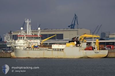
TACCOLA
Trailing Suction Hopper Dredger
Current Trip
KM 408 ALVEAR
| Time Travelled | 3 days |
|---|---|
| Remaining Time | --- |
| Distance Travelled | 161.37 nm |
| Remaining Distance | --- |
| AVG Speed | 7.1 Knopen |
| MAX Speed | 13.2 Knopen |
| AVG Wind | 5.4 knots |
| MAX Wind | 13 knots |
| MIN Temp | 14.9°C / 58.82°F |
| MAX Temp | 23°C / 73.4°F |
| Diepgang | 7.3 M |
| Positie ontvangen | 21 h, 1 m geleden |
Current Position
| Lengtegraad | -60.11145° |
|---|---|
| Breedtegraat | -33.36692° |
| Status | Under way using engine |
| Snelheid | 0.4 Knopen |
| Koers | 288° |
| Gebied | Rio de La Plata |
| Station | T-AIS |
| Positie ontvangen | 21 h, 1 m geleden |
Info
Information
The current position of TACCOLA is in Rio de La Plata with coordinates -33.36692° / -60.11145° as reported on 2024-04-15 07:00 by AIS to our vessel tracker app. The vessel's current speed is 0.4 Knopen
The vessel TACCOLA (IMO: 9280213, MMSI: 253454000) is a Trailing Suction Hopper Dredger that was built in 2003 ( 21 Jaar oud ). It's sailing under the flag of [LU] Luxembourg.
In this page you can find informations about the vessels current position, last detected port calls, and current voyage information. If the vessels is not in coverage by AIS you will find the latest position.
The current position of TACCOLA is detected by our AIS receivers and we are not responsible for the reliability of the data. The last position was recorded while the vessel was in Coverage by the Ais receivers of our vessel tracking app.
The current draught of TACCOLA as reported by AIS is 7.3 meters
Weather
| Temperature | 16.1°C / 60.98°F |
|---|---|
| Wind Speed | 5 knots |
| Direction | 298° WNW |
| Pressure | 1006.2 hPa |
| Humidity | 92.8 % |
| Cloud Coverage | 100 % |
Featured Company
Last Port Calls
| Port | Arrival | Departure | Time In Port |
|---|---|---|---|
| 2024-04-09 10:10 | 2024-04-12 21:09 | 3 d | |
| 2024-03-18 10:06 | 2024-03-19 22:38 | 1 d | |
| 2024-02-27 15:38 | 2024-03-12 21:07 | 14 d | |
| 2024-02-15 12:06 | 2024-02-26 21:21 | 11 d |
Most Visited Ports (Last year)
| Port | Arrivals | |
|---|---|---|
| 94 | ||
| 62 | ||
| 19 | ||
| 5 | ||
| 2 | ||
| 2 |
Last Trips
| Origin | Departure | Destination | Arrival | Distance | |
|---|---|---|---|---|---|
| 2024-03-19 19:38 | 2024-04-09 07:10 | 1168.19 nm | |||
| 2024-03-12 18:07 | 2024-03-18 07:06 | 290.53 nm | |||
| 2024-02-26 18:21 | 2024-02-27 12:38 | 180.49 nm | |||
| 2024-01-30 02:20 | 2024-02-15 09:06 | 4780.29 nm |
Events
| Tijd | Evenement | Details | Positie / Bestemming | Info |
|---|---|---|---|---|
| 2024-04-16 03:19 | Stop beweging | 3.13 nm, East of SAN NICOLAS |
-33.36500 / -60.11167
KM 408 ALVEAR
|
Snelheid: Koers: -1° |
| 2024-04-15 19:00 | Start beweging | 2.37 nm, East of SAN NICOLAS |
-33.36282 / -60.12663
KM 408 ALVEAR
|
Snelheid: 8.6 kn Koers: 105° |
| 2024-04-15 18:46 | Stop beweging | 1.7 nm, East of SAN NICOLAS |
-33.35945 / -60.13925
KM 408 ALVEAR
|
Snelheid: 0.2 kn Koers: 300° |
| 2024-04-15 18:19 | Start beweging | 3.16 nm, East of SAN NICOLAS |
-33.36666 / -60.11167
KM 408 ALVEAR
|
Snelheid: 5 kn Koers: 307° |
| 2024-04-15 17:43 | Stop beweging | 3.76 nm, East of SAN NICOLAS |
-33.37333 / -60.10166
KM 408 ALVEAR
|
Snelheid: Koers: -1° |
| 2024-04-15 16:38 | Start beweging | 2.32 nm, East of SAN NICOLAS |
-33.36257 / -60.12747
KM 408 ALVEAR
|
Snelheid: 8.3 kn Koers: 104° |
| 2024-04-15 16:19 | Stop beweging | 1.57 nm, East of SAN NICOLAS |
-33.35833 / -60.14167
KM 408 ALVEAR
|
Snelheid: Koers: -1° |
| 2024-04-15 11:58 | Start beweging | 2.38 nm, East of SAN NICOLAS |
-33.36333 / -60.12667
KM 408 ALVEAR
|
Snelheid: 8 kn Koers: 98° |
| 2024-04-15 09:55 | Stop beweging | 1.57 nm, East of SAN NICOLAS |
-33.35833 / -60.14167
KM 408 ALVEAR
|
Snelheid: Koers: -1° |
| 2024-04-15 08:42 | Start beweging | 2.08 nm, East of SAN NICOLAS |
-33.36215 / -60.13237
KM 408 ALVEAR
|
Snelheid: 10.7 kn Koers: 105° |