
FWN SEA
Cargo
Current Trip
TH MAT
| Time Travelled | 47 mins |
|---|---|
| Remaining Time | --- |
| Distance Travelled | 5.77 nm |
| Remaining Distance | --- |
| AVG Speed | 8.6 Knopen |
| MAX Speed | 12.8 Knopen |
| AVG Wind | 13.8 knots |
| MAX Wind | 14.9 knots |
| MIN Temp | 30°C / 86°F |
| MAX Temp | 30.3°C / 86.54°F |
| Diepgang | 5.2 M |
| Positie ontvangen | 1 d geleden |
Current Position
| Lengtegraad | 102.15285° |
|---|---|
| Breedtegraat | 10.23160° |
| Status | Under way using engine |
| Snelheid | 13.3 Knopen |
| Koers | 336.7° |
| Gebied | Gulf of Thailand |
| Station | T-AIS |
| Positie ontvangen | 1 d geleden |
Info
Information
The current position of FWN SEA is in Gulf of Thailand with coordinates 10.23160° / 102.15285° as reported on 2024-04-19 11:35 by AIS to our vessel tracker app. The vessel's current speed is 13.3 Knopen
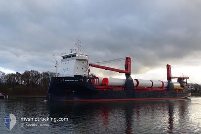
The vessel FWN SEA (IMO: 9721657, MMSI: 244770273) is a Cargo It's sailing under the flag of [NL] Netherlands.
In this page you can find informations about the vessels current position, last detected port calls, and current voyage information. If the vessels is not in coverage by AIS you will find the latest position.
The current position of FWN SEA is detected by our AIS receivers and we are not responsible for the reliability of the data. The last position was recorded while the vessel was in Coverage by the Ais receivers of our vessel tracking app.
The current draught of FWN SEA as reported by AIS is 5.2 meters
Weather
| Temperature | 30.2°C / 86.36°F |
|---|---|
| Wind Speed | 14 knots |
| Direction | 147° SSE |
| Pressure | 1005 hPa |
| Humidity | 77.4 % |
| Cloud Coverage | 1 % |
Featured Company
Last Port Calls
| Port | Arrival | Departure | Time In Port |
|---|---|---|---|
| 2024-04-20 00:48 | 2024-04-20 12:36 | 11 h | |
| 2024-04-15 15:47 | 2024-04-16 19:39 | 1 d | |
| 2024-04-06 04:00 | 2024-04-12 01:14 | 5 d | |
| 2024-03-26 07:43 | 2024-04-06 02:23 | 10 d | |
| 2024-03-17 06:20 | 2024-03-26 06:23 | 9 d |
Last Trips
| Origin | Departure | Destination | Arrival | Distance | |
|---|---|---|---|---|---|
| 2024-04-17 03:39 | 2024-04-20 07:48 | 962.95 nm | |||
| 2024-04-12 09:14 | 2024-04-15 23:47 | 237.18 nm | |||
| 2024-04-06 10:23 | 2024-04-06 12:00 | 10.16 nm | |||
| 2024-03-26 14:23 | 2024-03-26 15:43 | 10.15 nm | |||
| 2023-12-20 09:14 | 2024-03-17 14:20 | 85.16 nm |
Events
| Tijd | Evenement | Details | Positie / Bestemming | Info |
|---|---|---|---|---|
| 2024-04-20 12:36 | Vertrekhaven |
|
12.62530 / 101.15535
TH MAT
|
Snelheid: 9.6 kn Koers: 166° |
| 2024-04-20 12:17 | Start beweging |
12.66552 / 101.14265
[TH] MAP TA PHUT
|
Snelheid: 5.3 kn Koers: 140° |
|
| 2024-04-20 01:30 | Stop beweging |
12.67080 / 101.13924
[TH] MAP TA PHUT
|
Snelheid: Koers: 1° |
|
| 2024-04-20 00:48 | Aankomsthaven |
|
12.63573 / 101.15327
[TH] MAP TA PHUT
|
Snelheid: 9.1 kn Koers: 348° |
| 2024-04-19 11:35 | Buitenbereik |
10.23160 / 102.15285
Gulf of Thailand
TH MAT
|
Snelheid: 13.3 kn Koers: 336.7° |
|
| 2024-04-19 11:35 | Gevonden in zee | Cambodian part of the Gulf of Thailand |
10.23160 / 102.15285
Gulf of Thailand
TH MAT
|
Snelheid: 13.3 kn Koers: 336.7° |
| 2024-04-19 11:35 | Binnenbereik |
10.23160 / 102.15285
Gulf of Thailand
TH MAT
|
Snelheid: 13.3 kn Koers: 336.7° |
|
| 2024-04-17 15:57 | Status Changed | Default Under way using engine |
1.37443 / 104.43835
TH MAT
|
Snelheid: 12.1 kn Koers: 49.1° |
| 2024-04-17 15:53 | Buitenbereik |
1.36732 / 104.43023
South China Sea
TH MAT
|
Snelheid: 12.1 kn Koers: 49.1° |
|
| 2024-04-17 15:47 | Status Changed | Under way using engine Default |
1.35318 / 104.41428
TH MAT
|
Snelheid: 11.9 kn Koers: 48° |