
SEVEN SINS
Other Type
Current Trip
| Time Travelled | 2 days |
|---|---|
| Remaining Time | 32 mins |
| Distance Travelled | 727.16 nm |
| Remaining Distance | 6.34 nm |
| AVG Speed | 10.2 Knopen |
| MAX Speed | 13.2 Knopen |
| AVG Wind | 7.9 knots |
| MAX Wind | 15 knots |
| MIN Temp | 14.7°C / 58.46°F |
| MAX Temp | 22.1°C / 71.78°F |
| Diepgang | 2.7 M |
| Positie ontvangen | 1 m geleden |
Current Position
| Lengtegraad | -5.29312° |
|---|---|
| Breedtegraat | 36.08794° |
| Status | Under way using engine |
| Snelheid | 8.8 Knopen |
| Koers | 291.4° |
| Gebied | Alboran Sea |
| Station | T-AIS |
| Positie ontvangen | 1 m geleden |
Info
Information
The current position of SEVEN SINS is in Alboran Sea with coordinates 36.08794° / -5.29312° as reported on 2024-04-20 06:55 by AIS to our vessel tracker app. The vessel's current speed is 8.8 Knopen and is heading at the port of GIBRALTAR. The estimated time of arrival as calculated by MyShipTracking vessel tracking app is 2024-04-20 07:29 LT
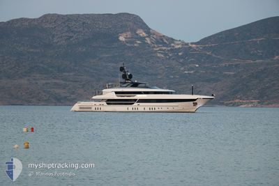
The vessel SEVEN SINS (IMO: 9822827, MMSI: 319114300) is a Other Type It's sailing under the flag of [KY] Cayman Is.
In this page you can find informations about the vessels current position, last detected port calls, and current voyage information. If the vessels is not in coverage by AIS you will find the latest position.
The current position of SEVEN SINS is detected by our AIS receivers and we are not responsible for the reliability of the data. The last position was recorded while the vessel was in Coverage by the Ais receivers of our vessel tracking app.
The current draught of SEVEN SINS as reported by AIS is 2.7 meters
Weather
| Temperature | 16.5°C / 61.7°F |
|---|---|
| Wind Speed | 15 knots |
| Direction | 99° E |
| Pressure | 1014.6 hPa |
| Humidity | 72.6 % |
| Cloud Coverage | 100 % |
Featured Company
Last Port Calls
| Port | Arrival | Departure | Time In Port |
|---|---|---|---|
| 2024-04-17 07:33 | 2024-04-17 13:22 | 5 h | |
| 2024-04-04 15:10 | 2024-04-07 15:46 | 3 d | |
| 2024-04-03 16:16 | |||
| 2024-03-26 16:12 | 2024-03-28 18:33 | 2 d | |
| 2024-03-17 00:05 | 2024-03-20 14:21 | 3 d | |
| 2024-03-08 15:47 | 2024-03-10 21:34 | 2 d | |
| 2024-03-07 20:58 | 2024-03-08 14:33 | 17 h | |
| 2024-03-06 14:05 | 2024-03-07 15:06 | 1 d | |
| 2024-02-26 21:48 | 2024-02-29 13:58 | 2 d | |
| 2024-02-05 20:27 | 2024-02-09 19:14 | 3 d |
Last Trips
| Origin | Departure | Destination | Arrival | Distance | |
|---|---|---|---|---|---|
| 2024-04-07 11:46 | 2024-04-17 08:33 | 2679.33 nm | |||
| 2024-04-03 12:16 | 2024-04-04 11:10 | 12.88 nm | |||
| 2024-03-20 10:21 | 2024-03-26 12:12 | 156.00 nm | |||
| 2024-03-10 17:34 | 2024-03-16 20:05 | 137.08 nm | |||
| 2024-03-08 10:33 | 2024-03-08 11:47 | 11.13 nm | |||
| 2024-03-07 11:06 | 2024-03-07 16:58 | 15.52 nm | |||
| 2024-02-29 09:58 | 2024-03-06 10:05 | 103.00 nm | |||
| 2024-02-09 15:14 | 2024-02-26 17:48 | 631.22 nm | |||
| 2024-02-05 16:09 | 2024-02-05 16:27 | 1.55 nm | |||
| 2024-01-27 17:52 | 2024-02-05 12:26 | 41.81 nm |
Events
| Tijd | Evenement | Details | Positie / Bestemming | Info |
|---|---|---|---|---|
| 2024-04-20 06:07 | Wijzig zee gebeid | Gibraltarian part of the Alboran Sea Spanish part of the Alboran Sea |
36.03083 / -5.24949
Alboran Sea
GIB
|
Snelheid: 8 kn Koers: 56.9° |
| 2024-04-20 05:50 | Wijzig zee gebeid | Spanish part of the Alboran Sea Spanish part of the Strait of Gibraltar |
36.01100 / -5.28934
Alboran Sea
GIB
|
Snelheid: 8 kn Koers: 60.2° |
| 2024-04-20 05:17 | Wijzig zee gebeid | Spanish part of the Strait of Gibraltar Moroccan part of the Strait of Gibraltar |
35.97965 / -5.37690
Strait of Gibraltar
GIB
|
Snelheid: 8.6 kn Koers: 68.8° |
| 2024-04-20 04:10 | Wijzig zee gebeid | Moroccan part of the Strait of Gibraltar Moroccan part of the North Atlantic Ocean |
35.91990 / -5.59250
Strait of Gibraltar
GIB
|
Snelheid: 11 kn Koers: 72.4° |
| 2024-04-20 04:09 | Binnenbereik |
35.91990 / -5.59250
Strait of Gibraltar
GIB
|
Snelheid: 11 kn Koers: 72.4° |
|
| 2024-04-19 20:15 | Buitenbereik |
34.89820 / -7.25747
North Atlantic Ocean
GIB
|
Snelheid: 12.8 kn Koers: 52.2° |
|
| 2024-04-19 19:31 | Binnenbereik |
34.80259 / -7.40841
North Atlantic Ocean
GIB
|
Snelheid: 13.3 kn Koers: 52.2° |
|
| 2024-04-19 01:04 | Buitenbereik |
32.68930 / -10.65767
North Atlantic Ocean
GIB
|
Snelheid: 11.4 kn Koers: 56.6° |
|
| 2024-04-19 00:35 | Gevonden in zee | Moroccan part of the North Atlantic Ocean |
32.63007 / -10.74379
North Atlantic Ocean
GIB
|
Snelheid: 11.5 kn Koers: 51.5° |
| 2024-04-19 00:35 | Binnenbereik |
32.63007 / -10.74379
North Atlantic Ocean
GIB
|
Snelheid: 11.5 kn Koers: 51.5° |