
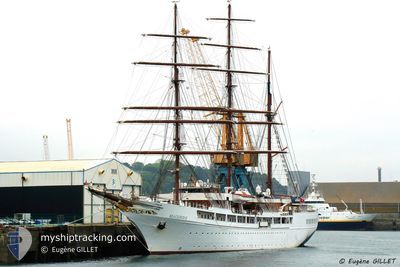
SEA CLOUD II
Passengers Ship
Current Trip
| Time Travelled | 9 days |
|---|---|
| Remaining Time | 3 days |
| Distance Travelled | 2397.13 nm |
| Remaining Distance | 1145.82 nm |
| AVG Speed | 10.2 Knopen |
| MAX Speed | 12.6 Knopen |
| AVG Wind | 15.9 knots |
| MAX Wind | 24.9 knots |
| MIN Temp | 18.9°C / 66.02°F |
| MAX Temp | 27.8°C / 82.04°F |
| Diepgang | 6 M |
| Positie ontvangen | 9 d geleden |
Current Position
| Lengtegraad | -62.86821° |
|---|---|
| Breedtegraat | 18.03223° |
| Status | Under way using engine |
| Snelheid | 11.1 Knopen |
| Koers | 68.6° |
| Gebied | Caribbean Sea |
| Station | T-AIS |
| Positie ontvangen | 9 d geleden |
Info
Information
The current position of SEA CLOUD II is in Caribbean Sea with coordinates 18.03223° / -62.86821° as reported on 2024-04-08 21:31 by AIS to our vessel tracker app. The vessel's current speed is 11.1 Knopen and is heading at the port of LISBOA. The estimated time of arrival as calculated by MyShipTracking vessel tracking app is 2024-04-21 08:06 LT
The vessel SEA CLOUD II (IMO: 9171292, MMSI: 248953000) is a Passengers Ship that was built in 2000 ( 24 Jaar oud ). It's sailing under the flag of [MT] Malta.
In this page you can find informations about the vessels current position, last detected port calls, and current voyage information. If the vessels is not in coverage by AIS you will find the latest position.
The current position of SEA CLOUD II is detected by our AIS receivers and we are not responsible for the reliability of the data. The last position was recorded while the vessel was in Coverage by the Ais receivers of our vessel tracking app.
The current draught of SEA CLOUD II as reported by AIS is 6 meters
Weather
| Temperature | 18.9°C / 66.02°F |
|---|---|
| Wind Speed | 13 knots |
| Direction | 259° W |
| Pressure | 1014 hPa |
| Humidity | 79.4 % |
| Cloud Coverage | 51 % |
Featured Company
Last Port Calls
| Port | Arrival | Departure | Time In Port |
|---|---|---|---|
| 2024-04-08 10:59 | 2024-04-08 20:27 | 9 h | |
| 2024-03-28 10:42 | 2024-03-29 01:37 | 14 h | |
| 2024-03-18 10:42 | 2024-03-18 22:58 | 12 h | |
| 2024-03-11 09:48 | 2024-03-11 23:05 | 13 h | |
| 2024-03-01 10:58 | 2024-03-02 01:31 | 14 h | |
| 2024-02-27 11:43 | 2024-02-27 23:02 | 11 h | |
| 2024-02-18 16:52 | 2024-02-18 22:51 | 5 h | |
| 2024-02-16 10:58 | 2024-02-17 02:13 | 15 h | |
| 2024-02-13 11:28 | 2024-02-13 22:37 | 11 h | |
| 2024-02-11 11:36 | 2024-02-11 17:36 | 6 h |
Last Trips
| Origin | Departure | Destination | Arrival | Distance | |
|---|---|---|---|---|---|
| 2024-03-28 21:37 | 2024-04-08 06:59 | 1052.36 nm | |||
| 2024-03-18 18:58 | 2024-03-28 06:42 | 911.94 nm | |||
| 2024-03-11 19:05 | 2024-03-18 06:42 | 601.16 nm | |||
| 2024-03-01 21:31 | 2024-03-11 05:48 | 661.14 nm | |||
| 2024-02-27 19:02 | 2024-03-01 06:58 | 356.81 nm | |||
| 2024-02-18 18:51 | 2024-02-27 07:43 | 724.11 nm | |||
| 2024-02-16 22:13 | 2024-02-18 12:52 | 252.15 nm | |||
| 2024-02-13 18:37 | 2024-02-16 06:58 | 340.47 nm | |||
| 2024-02-11 13:36 | 2024-02-13 07:28 | 204.93 nm | |||
| 2024-02-04 18:41 | 2024-02-11 07:36 | 695.54 nm |
Events
| Tijd | Evenement | Details | Positie / Bestemming | Info |
|---|---|---|---|---|
| 2024-04-08 21:38 | Status Changed | Default Under way using engine |
18.03833 / -62.84667
PT LIS
|
Snelheid: 11.1 kn Koers: 68.6° |
| 2024-04-08 21:31 | Gevonden in zee | Saint-Martin part of the Caribbean Sea |
18.03223 / -62.86821
Caribbean Sea
PT LIS
|
Snelheid: 11.1 kn Koers: 68.6° |
| 2024-04-08 21:31 | Status Changed | Under way using engine Default |
18.03223 / -62.86821
PT LIS
|
Snelheid: 11.1 kn Koers: 69° |
| 2024-04-08 21:31 | Buitenbereik |
18.03223 / -62.86821
Caribbean Sea
PT LIS
|
Snelheid: 11.1 kn Koers: 68.6° |
|
| 2024-04-08 20:43 | Status Changed | Default Under way using engine |
18.00179 / -63.02013
PT LIS
|
Snelheid: 11 kn Koers: 88.2° |
| 2024-04-08 20:30 | Start beweging | 0.56 nm, South of PHILIPSBURG |
18.00521 / -63.05077
PT LIS
|
Snelheid: 3.1 kn Koers: 196° |
| 2024-04-08 20:27 | Vertrekhaven |
|
18.00587 / -63.04913
PT LIS
|
Snelheid: 1.7 kn Koers: 335° |
| 2024-04-08 20:04 | Status Changed | Under way using engine Default |
18.01075 / -63.04758
[SX] PHILIPSBURG
|
Snelheid: 0.7 kn Koers: 32° |
| 2024-04-08 20:00 | Status Changed | Default Under way using engine |
18.01068 / -63.04755
[SX] PHILIPSBURG
|
Snelheid: 0.7 kn Koers: 26° |
| 2024-04-08 19:59 | Draught Changed | 6 5.9 |
18.01086 / -63.04742
[SX] PHILIPSBURG
|
Snelheid: 0.7 kn Koers: 26° |