
PERLITE
General Cargo
Current Trip
| Time Travelled | 22 h, 18 mins |
|---|---|
| Remaining Time | -15 mins |
| Distance Travelled | 95.77 nm |
| Remaining Distance | 0.68 nm |
| AVG Speed | 8.9 Knopen |
| MAX Speed | 11.7 Knopen |
| AVG Wind | 12.8 knots |
| MAX Wind | 17.8 knots |
| MIN Temp | 17.2°C / 62.96°F |
| MAX Temp | 18.4°C / 65.12°F |
| Diepgang | 3.6 M |
| Positie ontvangen | 3 m geleden |
Current Position
| Lengtegraad | 27.13655° |
|---|---|
| Breedtegraat | 36.65063° |
| Status | At anchor |
| Snelheid | 0.7 Knopen |
| Koers | --- |
| Gebied | Aegean Sea |
| Station | T-AIS |
| Positie ontvangen | 3 m geleden |
Info
Information
The current position of PERLITE is in Aegean Sea with coordinates 36.65063° / 27.13655° as reported on 2024-04-25 04:02 by AIS to our vessel tracker app. The vessel's current speed is 0.7 Knopen and is heading at the port of GYALI. The estimated time of arrival as calculated by MyShipTracking vessel tracking app is 2024-04-25 03:51 LT
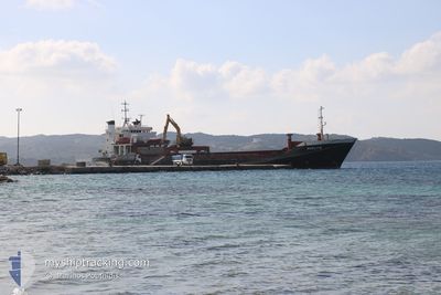
The vessel PERLITE (IMO: 7928251, MMSI: 240188500) is a General Cargo that was built in 1981 ( 43 Jaar oud ). It's sailing under the flag of [GR] Greece.
In this page you can find informations about the vessels current position, last detected port calls, and current voyage information. If the vessels is not in coverage by AIS you will find the latest position.
The current position of PERLITE is detected by our AIS receivers and we are not responsible for the reliability of the data. The last position was recorded while the vessel was in Coverage by the Ais receivers of our vessel tracking app.
The current draught of PERLITE as reported by AIS is 3.6 meters
Weather
| Temperature | 17.2°C / 62.96°F |
|---|---|
| Wind Speed | 8 knots |
| Direction | 218° SW |
| Pressure | 1006.5 hPa |
| Humidity | 77.8 % |
| Cloud Coverage | 100 % |
Featured Company
Last Port Calls
| Port | Arrival | Departure | Time In Port |
|---|---|---|---|
| 2024-04-22 15:26 | 2024-04-24 05:48 | 1 d | |
| 2024-04-17 15:09 | 2024-04-19 16:10 | 2 d | |
| 2024-04-14 00:17 | 2024-04-15 14:26 | 1 d | |
| 2024-04-10 07:34 | 2024-04-11 11:21 | 1 d | |
| 2024-04-07 05:39 | 2024-04-07 15:27 | 9 h | |
| 2024-04-04 08:35 | 2024-04-06 11:17 | 2 d | |
| 2024-03-31 10:16 | 2024-04-02 10:23 | 2 d | |
| 2024-03-30 05:42 | 2024-03-30 15:31 | 9 h | |
| 2024-03-28 10:59 | 2024-03-29 13:06 | 1 d | |
| 2024-03-22 14:01 | 2024-03-23 16:23 | 1 d |
Most Visited Ports (Last year)
| Port | Arrivals | |
|---|---|---|
| 37 | ||
| 29 | ||
| 18 | ||
| 17 | ||
| 16 | ||
| 4 |
Last Trips
| Origin | Departure | Destination | Arrival | Distance | |
|---|---|---|---|---|---|
| 2024-04-19 19:10 | 2024-04-22 18:26 | 430.20 nm | |||
| 2024-04-15 17:26 | 2024-04-17 18:09 | 505.37 nm | |||
| 2024-04-11 14:21 | 2024-04-14 03:17 | 580.97 nm | |||
| 2024-04-07 18:27 | 2024-04-10 10:34 | 212.55 nm | |||
| 2024-04-06 14:17 | 2024-04-07 08:39 | 205.21 nm | |||
| 2024-04-02 13:23 | 2024-04-04 11:35 | 423.85 nm | |||
| 2024-03-30 17:31 | 2024-03-31 13:16 | 202.39 nm | |||
| 2024-03-29 15:06 | 2024-03-30 07:42 | 95.76 nm | |||
| 2024-03-23 18:23 | 2024-03-28 12:59 | 436.98 nm | |||
| 2024-03-19 17:41 | 2024-03-22 16:01 | 379.26 nm |
Events
| Tijd | Evenement | Details | Positie / Bestemming | Info |
|---|---|---|---|---|
| 2024-04-25 03:59 | Status Changed | At anchor Under way using engine |
36.65051 / 27.13583
GRYLI
|
Snelheid: 4.3 kn Koers: 22.7° |
| 2024-04-25 03:25 | Status Changed | Under way using engine Default |
36.61771 / 27.08500
GRYLI
|
Snelheid: 11 kn Koers: 76° |
| 2024-04-25 03:07 | Status Changed | Default Under way using engine |
36.60438 / 27.01813
GRYLI
|
Snelheid: 11.1 kn Koers: 75.6° |
| 2024-04-24 20:05 | Start beweging | 3.25 nm, North East of THIRASSIA |
36.48198 / 25.40413
GRYLI
|
Snelheid: 3.4 kn Koers: 338.2° |
| 2024-04-24 20:03 | Status Changed | Under way using engine At anchor |
36.48123 / 25.40544
GRYLI
|
Snelheid: 0.6 kn Koers: 511° |
| 2024-04-24 12:09 | Status Changed | At anchor Default |
36.48174 / 25.40758
GRYLI
|
Snelheid: 0.2 kn Koers: -1° |
| 2024-04-24 12:07 | Status Changed | Default At anchor |
36.48163 / 25.40755
GRYLI
|
Snelheid: 0.2 kn Koers: 511° |
| 2024-04-24 06:44 | Status Changed | At anchor Under way using engine |
36.48131 / 25.40724
GRYLI
|
Snelheid: 1.1 kn Koers: 511° |
| 2024-04-24 06:41 | Stop beweging | 3.33 nm, North East of THIRASSIA |
36.48152 / 25.40634
GRYLI
|
Snelheid: 0.2 kn Koers: 511° |
| 2024-04-24 05:48 | Vertrekhaven |
|
36.41743 / 25.40596
GRYLI
|
Snelheid: 8.8 kn Koers: 315.3° |