
PROFESSOR B
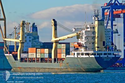
General Cargo
Current Trip
| Time Travelled | --- |
|---|---|
| Remaining Time | 16 h, 22 mins |
| Distance Travelled | --- |
| Remaining Distance | 190.74 nm |
| AVG Speed | --- |
| MAX Speed | --- |
| AVG Wind | --- |
| MAX Wind | --- |
| MIN Temp | --- |
| MAX Temp | --- |
| Diepgang | 8.2 M |
| Positie ontvangen | 1 h, 19 m geleden |
Current Position
| Lengtegraad | 29.42687° |
|---|---|
| Breedtegraat | 33.51623° |
| Status | Under way using engine |
| Snelheid | 11.6 Knopen |
| Koers | 131.1° |
| Gebied | Mediterranean Sea - Eastern Basin |
| Station | T-AIS |
| Positie ontvangen | 1 h, 19 m geleden |
Info
Information
The current position of PROFESSOR B is in Mediterranean Sea - Eastern Basin with coordinates 33.51623° / 29.42687° as reported on 2024-04-24 21:32 by AIS to our vessel tracker app. The vessel's current speed is 11.6 Knopen and is heading at the port of PORT SAID. The estimated time of arrival as calculated by MyShipTracking vessel tracking app is 2024-04-25 15:13 LT
The vessel PROFESSOR B (IMO: 8401523, MMSI: 620040000) is a General Cargo that was built in 1984 ( 40 Jaar oud ). It's sailing under the flag of [KM] Comoros.
In this page you can find informations about the vessels current position, last detected port calls, and current voyage information. If the vessels is not in coverage by AIS you will find the latest position.
The current position of PROFESSOR B is detected by our AIS receivers and we are not responsible for the reliability of the data. The last position was recorded while the vessel was in Coverage by the Ais receivers of our vessel tracking app.
The current draught of PROFESSOR B as reported by AIS is 8.2 meters
Weather
| Temperature | 19.2°C / 66.56°F |
|---|---|
| Wind Speed | 13 knots |
| Direction | 278° W |
| Pressure | 1007.2 hPa |
| Humidity | 90.4 % |
| Cloud Coverage | 100 % |
Featured Company
Last Port Calls
| Port | Arrival | Departure | Time In Port |
|---|---|---|---|
| 2024-03-28 23:06 | |||
| 2024-03-07 08:41 | 2024-03-11 10:20 | 4 d | |
| 2024-03-01 15:16 | |||
| 2024-02-08 17:56 | 2024-02-13 22:53 | 5 d | |
| 2024-02-05 19:05 | 2024-02-08 02:35 | 2 d | |
| 2024-02-03 13:01 | 2024-02-03 19:12 | 6 h |
Most Visited Ports (Last year)
| Port | Arrivals | |
|---|---|---|
| 5 | ||
| 4 | ||
| 3 | ||
| 3 | ||
| 2 | ||
| 2 |
Last Trips
| Origin | Departure | Destination | Arrival | Distance | |
|---|---|---|---|---|---|
| 2024-03-11 12:20 | 2024-03-29 02:06 | 699.86 nm | |||
| 2024-03-01 17:16 | 2024-03-07 10:41 | 943.32 nm | |||
| 2024-02-08 04:35 | 2024-02-08 19:56 | 130.93 nm | |||
| 2024-02-03 21:12 | 2024-02-05 21:05 | 7.86 nm | |||
| 2024-01-27 13:29 | 2024-02-03 15:01 | 1052.40 nm |
Events
| Tijd | Evenement | Details | Positie / Bestemming | Info |
|---|---|---|---|---|
| 2024-04-24 21:35 | Status Changed | Default Under way using engine |
33.50836 / 29.43759
PORT SAID
|
Snelheid: 11.6 kn Koers: 131.1° |
| 2024-04-24 21:32 | Buitenbereik |
33.51623 / 29.42687
Mediterranean Sea - Eastern Basin
PORT SAID
|
Snelheid: 11.6 kn Koers: 131.1° |
|
| 2024-04-24 21:29 | Status Changed | Under way using engine Default |
33.52188 / 29.41910
PORT SAID
|
Snelheid: 11.6 kn Koers: 131° |
| 2024-04-24 21:17 | Status Changed | Default Under way using engine |
33.54657 / 29.38478
PORT SAID
|
Snelheid: 11.6 kn Koers: 129.8° |
| 2024-04-24 21:05 | Status Changed | Under way using engine Default |
33.57307 / 29.34745
PORT SAID
|
Snelheid: 11.7 kn Koers: 129° |
| 2024-04-24 20:53 | Status Changed | Default Under way using engine |
33.59716 / 29.31279
PORT SAID
|
Snelheid: 11.7 kn Koers: 129.5° |
| 2024-04-24 20:50 | Status Changed | Under way using engine Default |
33.60367 / 29.30324
PORT SAID
|
Snelheid: 11.7 kn Koers: 128° |
| 2024-04-24 20:40 | Status Changed | Default Under way using engine |
33.62333 / 29.27167
PORT SAID
|
Snelheid: 11.6 kn Koers: 128.8° |
| 2024-04-24 20:26 | Wijzig zee gebeid | Egyptian part of the Mediterranean Sea - Eastern Basin Greek part of the Mediterranean Sea - Eastern Basin |
33.65319 / 29.23115
Mediterranean Sea - Eastern Basin
PORT SAID
|
Snelheid: 11.4 kn Koers: 130.6° |
| 2024-04-24 20:25 | Status Changed | Under way using engine Default |
33.65429 / 29.22962
PORT SAID
|
Snelheid: 11.3 kn Koers: 130° |