
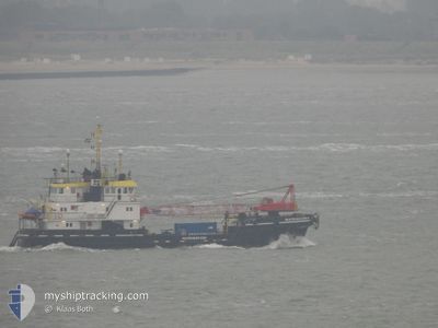
MULTRASALVOR 4
Salvage/Rescue Vessel
Current Trip
| Trip Time | 3 days |
|---|---|
| Trip Distance | 55.97 nm |
| AVG Speed | 7.1 Knopen |
| MAX Speed | 8.3 Knopen |
| Diepgang | 3 M |
| AVG Wind | 5.4 knots |
| MAX Wind | 13.9 knots |
| MIN Temp | 13.2°C / 55.76°F |
| MAX Temp | 21.2°C / 70.16°F |
| Positie ontvangen | 18 d geleden |
Current Position
| Lengtegraad | 2.74991° |
|---|---|
| Breedtegraat | 36.67950° |
| Status | At anchor |
| Snelheid | |
| Koers | 242° |
| Gebied | Mediterranean Sea - Western Basin |
| Station | T-AIS |
| Positie ontvangen | 18 d geleden |
Info
Information
The current position of MULTRASALVOR 4 is in Mediterranean Sea - Western Basin with coordinates 36.67950° / 2.74991° as reported on 2024-04-05 06:50 by AIS to our vessel tracker app. The vessel's current speed is 0 Knopen and is currently inside the port of ALGER.
The vessel MULTRASALVOR 4 (IMO: 8224286, MMSI: 246490000) is a Salvage/Rescue Vessel that was built in 1983 ( 41 Jaar oud ). It's sailing under the flag of [NL] Netherlands.
In this page you can find informations about the vessels current position, last detected port calls, and current voyage information. If the vessels is not in coverage by AIS you will find the latest position.
The current position of MULTRASALVOR 4 is detected by our AIS receivers and we are not responsible for the reliability of the data. The last position was recorded while the vessel was in Coverage by the Ais receivers of our vessel tracking app.
The current draught of MULTRASALVOR 4 as reported by AIS is 3 meters
Weather
| Temperature | 15°C / 59°F |
|---|---|
| Wind Speed | 8 knots |
| Direction | 70° ENE |
| Pressure | 1015.1 hPa |
| Humidity | 61.5 % |
| Cloud Coverage | 9 % |
Featured Company
Last Port Calls
| Port | Arrival | Departure | Time In Port |
|---|---|---|---|
| 2024-04-16 17:17 | |||
| 2024-04-10 14:29 | 2024-04-13 05:29 | 2 d | |
| 2024-04-08 13:38 | 2024-04-10 07:32 | 1 d | |
| 2024-04-06 06:20 | 2024-04-06 14:53 | 8 h | |
| 2024-03-29 12:44 | 2024-04-02 04:27 | 3 d | |
| 2024-03-28 13:02 | |||
| 2024-03-08 07:05 | 2024-03-10 16:31 | 2 d | |
| 2024-03-03 20:16 | 2024-03-04 17:14 | 20 h | |
| 2024-02-28 10:27 | 2024-03-02 20:30 | 3 d | |
| 2024-02-26 18:30 | 2024-02-28 04:28 | 1 d |
Last Trips
| Origin | Departure | Destination | Arrival | Distance | |
|---|---|---|---|---|---|
| 2024-04-13 06:29 | 2024-04-16 18:17 | 55.97 nm | |||
| 2024-04-10 08:32 | 2024-04-10 15:29 | 43.71 nm | |||
| 2024-04-06 15:53 | 2024-04-08 14:38 | 55.65 nm | |||
| 2024-04-02 05:27 | 2024-04-06 07:20 | 72.36 nm | |||
| 2024-03-28 14:02 | 2024-03-29 13:44 | 44.52 nm | |||
| 2024-03-04 18:14 | 2024-03-08 08:05 | 537.68 nm | |||
| 2024-03-02 21:30 | 2024-03-03 21:16 | 217.89 nm | |||
| 2024-02-28 05:28 | 2024-02-28 11:27 | 27.14 nm | |||
| 2024-02-26 16:51 | 2024-02-26 19:30 | 26.40 nm | |||
| 2024-02-26 15:23 | 2024-02-26 15:29 | 0.34 nm |
Events
| Tijd | Evenement | Details | Positie / Bestemming | Info |
|---|---|---|---|---|
| 2024-04-16 17:27 | Stop beweging |
36.76333 / 3.06667
[DZ] ALGER
|
Snelheid: Koers: -1° |
|
| 2024-04-16 17:17 | Aankomsthaven |
|
36.76285 / 3.07696
[DZ] ALGER
|
Snelheid: 7.7 kn Koers: 166° |
| 2024-04-16 17:04 | Start beweging | 0.83 nm, North East of ALGER |
36.77748 / 3.08626
FOUKA
|
Snelheid: 4.5 kn Koers: 183° |
| 2024-04-16 16:43 | Stop beweging | 1.01 nm, North East of ALGER |
36.78012 / 3.08837
FOUKA
|
Snelheid: 0.2 kn Koers: 75° |
| 2024-04-16 13:42 | Start beweging | 5.04 nm, North East of PORT DE CHIFFALO |
36.69231 / 2.75145
FOUKA
|
Snelheid: 5.7 kn Koers: 358° |
| 2024-04-13 09:21 | Stop beweging | 4.41 nm, North East of PORT DE CHIFFALO |
36.67833 / 2.74833
FOUKA
|
Snelheid: Koers: -1° |