
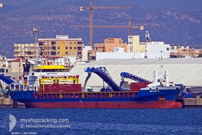
SEHER S
General Cargo
Current Trip
| Time Travelled | 13 days |
|---|---|
| Remaining Time | --- |
| Distance Travelled | 3011.80 nm |
| Remaining Distance | --- |
| AVG Speed | 9.7 Knopen |
| MAX Speed | 9.7 Knopen |
| AVG Wind | 15.3 knots |
| MAX Wind | 29 knots |
| MIN Temp | 12.8°C / 55.04°F |
| MAX Temp | 25.1°C / 77.18°F |
| Diepgang | 5.3 M |
| Positie ontvangen | 2 m geleden |
Current Position
| Lengtegraad | 35.49077° |
|---|---|
| Breedtegraat | 33.81823° |
| Status | Moored |
| Snelheid | |
| Koers | 177° |
| Gebied | Mediterranean Sea - Eastern Basin |
| Station | T-AIS |
| Positie ontvangen | 2 m geleden |
Info
Information
The current position of SEHER S is in Mediterranean Sea - Eastern Basin with coordinates 33.81823° / 35.49077° as reported on 2024-04-19 04:01 by AIS to our vessel tracker app. The vessel's current speed is 0 Knopen
The vessel SEHER S (IMO: 9198604, MMSI: 375115000) is a General Cargo that was built in 2001 ( 23 Jaar oud ). It's sailing under the flag of [VC] St Vincent Grenadines.
In this page you can find informations about the vessels current position, last detected port calls, and current voyage information. If the vessels is not in coverage by AIS you will find the latest position.
The current position of SEHER S is detected by our AIS receivers and we are not responsible for the reliability of the data. The last position was recorded while the vessel was in Coverage by the Ais receivers of our vessel tracking app.
The current draught of SEHER S as reported by AIS is 5.3 meters
Weather
| Temperature | 16.4°C / 61.52°F |
|---|---|
| Wind Speed | 5 knots |
| Direction | 209° SSW |
| Pressure | 1013.3 hPa |
| Humidity | 84.7 % |
| Cloud Coverage | --- |
Featured Company
Last Port Calls
| Port | Arrival | Departure | Time In Port |
|---|---|---|---|
| 2024-04-01 18:00 | 2024-04-05 17:47 | 3 d | |
| 2024-03-20 21:52 | 2024-03-23 15:11 | 2 d | |
| 2024-03-02 01:52 | 2024-03-04 23:02 | 2 d | |
| 2024-02-23 20:31 | 2024-02-28 15:10 | 4 d | |
| 2024-02-18 00:26 | 2024-02-20 20:41 | 2 d | |
| 2024-02-10 16:14 | 2024-02-13 15:31 | 2 d |
Last Trips
| Origin | Departure | Destination | Arrival | Distance | |
|---|---|---|---|---|---|
| 2024-03-23 15:11 | 2024-04-01 20:00 | 754.44 nm | |||
| 2024-03-05 02:02 | 2024-03-20 21:52 | 3211.88 nm | |||
| 2024-02-28 17:10 | 2024-03-02 04:52 | 366.07 nm | |||
| 2024-02-20 22:41 | 2024-02-23 22:31 | 701.10 nm | |||
| 2024-02-13 17:31 | 2024-02-18 02:26 | 136.90 nm | |||
| 2024-01-26 00:48 | 2024-02-10 18:14 | 3525.64 nm |
Events
| Tijd | Evenement | Details | Positie / Bestemming | Info |
|---|---|---|---|---|
| 2024-04-19 00:01 | Status Changed | Moored Under way using engine |
33.81825 / 35.49078
ILHFA
|
Snelheid: 0.1 kn Koers: 34° |
| 2024-04-18 21:57 | Status Changed | Under way using engine At anchor |
33.81827 / 35.49079
ILHFA
|
Snelheid: Koers: 296° |
| 2024-04-18 20:26 | Binnenbereik |
33.81829 / 35.49079
Mediterranean Sea - Eastern Basin
ILHFA
|
Snelheid: 0.1 kn Koers: 174.7° |
|
| 2024-04-18 18:48 | Buitenbereik |
32.90071 / 34.83150
Mediterranean Sea - Eastern Basin
ILHFA
|
Snelheid: 10.5 kn Koers: 95.8° |
|
| 2024-04-18 17:42 | Wijzig zee gebeid | Israeli part of the Mediterranean Sea - Eastern Basin Greek part of the Mediterranean Sea - Eastern Basin |
32.93481 / 34.59960
Mediterranean Sea - Eastern Basin
ILHFA
|
Snelheid: 8.9 kn Koers: 192.5° |
| 2024-04-18 17:41 | Binnenbereik |
32.93481 / 34.59960
Mediterranean Sea - Eastern Basin
ILHFA
|
Snelheid: 8.9 kn Koers: 192.5° |
|
| 2024-04-17 14:42 | Status Changed | Default Under way using engine |
34.22413 / 29.01994
ILHFA
|
Snelheid: 10.4 kn Koers: 107.3° |
| 2024-04-17 14:33 | Buitenbereik |
34.23144 / 28.98903
Mediterranean Sea - Eastern Basin
ILHFA
|
Snelheid: 10.4 kn Koers: 107.3° |
|
| 2024-04-17 14:13 | Status Changed | Under way using engine Default |
34.24716 / 28.92209
ILHFA
|
Snelheid: 10.9 kn Koers: 104° |
| 2024-04-17 14:13 | Binnenbereik |
34.24716 / 28.92209
Mediterranean Sea - Eastern Basin
ILHFA
|
Snelheid: 10.5 kn Koers: 106.7° |