
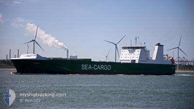
MISIDA
Ro-Ro Cargo
Current Trip
| Time Travelled | 2 days |
|---|---|
| Remaining Time | 32 mins |
| Distance Travelled | 801.32 nm |
| Remaining Distance | 8.13 nm |
| AVG Speed | 12 Knopen |
| MAX Speed | 15.5 Knopen |
| AVG Wind | 17.1 knots |
| MAX Wind | 27.3 knots |
| MIN Temp | 3.1°C / 37.58°F |
| MAX Temp | 9.3°C / 48.74°F |
| Diepgang | 6.8 M |
| Positie ontvangen | Nu |
Current Position
| Lengtegraad | 4.30182° |
|---|---|
| Breedtegraat | 51.89533° |
| Status | Under way using engine |
| Snelheid | 11 Knopen |
| Koers | 103.9° |
| Gebied | North Sea |
| Station | T-AIS |
| Positie ontvangen | Nu |
Info
Information
The current position of MISIDA is in North Sea with coordinates 51.89533° / 4.30182° as reported on 2024-04-19 05:07 by AIS to our vessel tracker app. The vessel's current speed is 11 Knopen and is heading at the port of ROTTERDAM. The estimated time of arrival as calculated by MyShipTracking vessel tracking app is 2024-04-19 05:40 LT
The vessel MISIDA (IMO: 9348948, MMSI: 230995000) is a Ro-Ro Cargo that was built in 2007 ( 17 Jaar oud ). It's sailing under the flag of [FI] Finland.
In this page you can find informations about the vessels current position, last detected port calls, and current voyage information. If the vessels is not in coverage by AIS you will find the latest position.
The current position of MISIDA is detected by our AIS receivers and we are not responsible for the reliability of the data. The last position was recorded while the vessel was in Coverage by the Ais receivers of our vessel tracking app.
The current draught of MISIDA as reported by AIS is 6.8 meters
Weather
| Temperature | 9.3°C / 48.74°F |
|---|---|
| Wind Speed | 18 knots |
| Direction | 285° WNW |
| Pressure | 1009.5 hPa |
| Humidity | 91.6 % |
| Cloud Coverage | 100 % |
Featured Company
Last Port Calls
| Port | Arrival | Departure | Time In Port |
|---|---|---|---|
| 2024-04-15 17:05 | 2024-04-16 10:35 | 17 h | |
| 2024-04-14 18:25 | 2024-04-14 20:45 | 2 h | |
| 2024-04-14 09:12 | 2024-04-14 10:53 | 1 h | |
| 2024-04-12 04:33 | 2024-04-12 17:49 | 13 h | |
| 2024-04-10 19:13 | 2024-04-10 20:25 | 1 h | |
| 2024-04-10 14:19 | 2024-04-10 17:07 | 2 h | |
| 2024-04-08 17:20 | 2024-04-09 08:36 | 15 h | |
| 2024-04-07 18:27 | 2024-04-07 20:50 | 2 h | |
| 2024-04-07 06:55 | 2024-04-07 10:52 | 3 h | |
| 2024-04-05 04:37 | 2024-04-05 19:37 | 14 h |
Most Visited Ports (Last year)
| Port | Arrivals | |
|---|---|---|
| 86 | ||
| 53 | ||
| 52 | ||
| 47 | ||
| 28 | ||
| 10 |
Last Trips
| Origin | Departure | Destination | Arrival | Distance | |
|---|---|---|---|---|---|
| 2024-04-14 22:45 | 2024-04-15 19:05 | 279.76 nm | |||
| 2024-04-14 12:53 | 2024-04-14 20:25 | 102.95 nm | |||
| 2024-04-12 19:49 | 2024-04-14 11:12 | 449.34 nm | |||
| 2024-04-10 22:25 | 2024-04-12 06:33 | 454.02 nm | |||
| 2024-04-10 19:07 | 2024-04-10 21:13 | 26.26 nm | |||
| 2024-04-09 10:36 | 2024-04-10 16:19 | 347.58 nm | |||
| 2024-04-07 22:50 | 2024-04-08 19:20 | 277.63 nm | |||
| 2024-04-07 12:52 | 2024-04-07 20:27 | 103.11 nm | |||
| 2024-04-05 21:37 | 2024-04-07 08:55 | 448.48 nm | |||
| 2024-04-03 19:13 | 2024-04-05 06:37 | 458.91 nm |
Events
| Tijd | Evenement | Details | Positie / Bestemming | Info |
|---|---|---|---|---|
| 2024-04-18 23:49 | Binnenbereik |
52.64249 / 3.88840
North Sea
ROTTERDAM
|
Snelheid: 13.2 kn Koers: 198.2° |
|
| 2024-04-18 21:15 | Buitenbereik |
53.09487 / 4.29152
North Sea
ROTTERDAM
|
Snelheid: 11.5 kn Koers: 227.8° |
|
| 2024-04-18 20:44 | Binnenbereik |
53.15609 / 4.39982
North Sea
ROTTERDAM
|
Snelheid: 11.8 kn Koers: 224.5° |
|
| 2024-04-18 19:39 | Buitenbereik |
53.37325 / 4.53573
North Sea
ROTTERDAM
|
Snelheid: 11.9 kn Koers: 197.6° |
|
| 2024-04-18 18:51 | Binnenbereik |
53.52497 / 4.61312
North Sea
ROTTERDAM
|
Snelheid: 11.8 kn Koers: 196° |
|
| 2024-04-18 09:40 | Buitenbereik |
55.07764 / 4.67886
North Sea
ROTTERDAM
|
Snelheid: 7.8 kn Koers: 164.5° |
|
| 2024-04-18 08:56 | Wijzig zee gebeid | Dutch part of the North Sea German part of the North Sea |
55.17041 / 4.63292
North Sea
ROTTERDAM
|
Snelheid: 7.8 kn Koers: 164.4° |
| 2024-04-18 05:50 | Wijzig zee gebeid | German part of the North Sea Danish part of the North Sea |
55.64745 / 4.41168
North Sea
ROTTERDAM
|
Snelheid: 12.8 kn Koers: 177.4° |
| 2024-04-18 02:17 | Wijzig zee gebeid | Danish part of the North Sea Norwegian part of the North Sea |
56.39629 / 4.35581
North Sea
ROTTERDAM
|
Snelheid: 12.6 kn Koers: 174.3° |
| 2024-04-18 00:43 | Status Changed | Under way using engine Default |
56.72658 / 4.31310
ROTTERDAM
|
Snelheid: 13 kn Koers: 176° |