
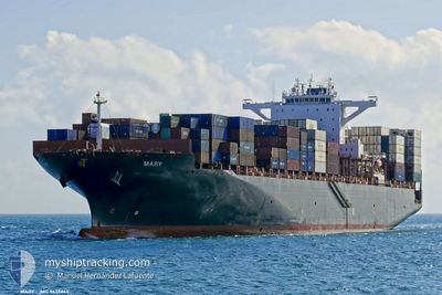
COLOMBIA EXPRESS
Container Ship
Current Trip
OPL-D
| Time Travelled | 30 days |
|---|---|
| Remaining Time | --- |
| Distance Travelled | 11645.85 nm |
| Remaining Distance | --- |
| AVG Speed | 15.2 Knopen |
| MAX Speed | 20.4 Knopen |
| AVG Wind | 14.8 knots |
| MAX Wind | 41 knots |
| MIN Temp | 4.7°C / 40.46°F |
| MAX Temp | 30°C / 86°F |
| Diepgang | 11.4 M |
| Positie ontvangen | Nu |
Current Position
| Lengtegraad | 54.75467° |
|---|---|
| Breedtegraat | 25.29743° |
| Status | Under way using engine |
| Snelheid | 13.9 Knopen |
| Koers | 39.7° |
| Gebied | Persian Gulf |
| Station | T-AIS |
| Positie ontvangen | Nu |
Info
Information
The current position of COLOMBIA EXPRESS is in Persian Gulf with coordinates 25.29743° / 54.75467° as reported on 2024-04-25 11:16 by AIS to our vessel tracker app. The vessel's current speed is 13.9 Knopen
The vessel COLOMBIA EXPRESS (IMO: 9635664, MMSI: 538004911) is a Container Ship that was built in 2013 ( 11 Jaar oud ). It's sailing under the flag of [MH] Marshall Is.
In this page you can find informations about the vessels current position, last detected port calls, and current voyage information. If the vessels is not in coverage by AIS you will find the latest position.
The current position of COLOMBIA EXPRESS is detected by our AIS receivers and we are not responsible for the reliability of the data. The last position was recorded while the vessel was in Coverage by the Ais receivers of our vessel tracking app.
The current draught of COLOMBIA EXPRESS as reported by AIS is 11.4 meters
Weather
| Temperature | 25.8°C / 78.44°F |
|---|---|
| Wind Speed | 12 knots |
| Direction | 51° NE |
| Pressure | 1005.5 hPa |
| Humidity | 73.3 % |
| Cloud Coverage | --- |
Featured Company
Last Port Calls
| Port | Arrival | Departure | Time In Port |
|---|---|---|---|
| 2024-03-24 04:03 | 2024-03-25 14:23 | 1 d | |
| 2024-03-21 13:02 | 2024-03-21 20:41 | 7 h | |
| 2024-03-19 09:22 | 2024-03-20 04:19 | 18 h | |
| 2024-03-16 08:44 | 2024-03-17 23:27 | 1 d | |
| 2024-02-09 07:10 | 2024-02-10 09:32 | 1 d | |
| 2024-02-04 03:01 | 2024-02-04 17:50 | 14 h |
Last Trips
| Origin | Departure | Destination | Arrival | Distance | |
|---|---|---|---|---|---|
| 2024-03-21 21:41 | 2024-03-24 05:03 | 125.06 nm | |||
| 2024-03-20 04:19 | 2024-03-21 14:02 | 474.14 nm | |||
| 2024-03-18 00:27 | 2024-03-19 09:22 | 277.26 nm | |||
| 2024-02-10 17:32 | 2024-03-16 09:44 | 11977.35 nm | |||
| 2024-02-05 01:50 | 2024-02-09 15:10 | 1473.73 nm | |||
| 2024-01-31 00:45 | 2024-02-04 11:01 | 1284.78 nm |
Events
| Tijd | Evenement | Details | Positie / Bestemming | Info |
|---|---|---|---|---|
| 2024-04-25 10:57 | Destination Changed | OPL-D AEJEA |
25.24354 / 54.70745
OPL-D
|
Snelheid: 7.8 kn Koers: 37.2° |
| 2024-04-25 10:57 | ETA Changed | 2024/04/25 16:30 2024/04/24 13:00 |
25.24354 / 54.70745
OPL-D
|
Snelheid: 7.8 kn Koers: 37.2° |
| 2024-04-25 10:52 | Start beweging |
25.23755 / 54.70250
AEJEA
|
Snelheid: 3.2 kn Koers: 39° |
|
| 2024-04-25 10:51 | Status Changed | Under way using engine At anchor |
25.23668 / 54.70192
AEJEA
|
Snelheid: 0.8 kn Koers: 41° |
| 2024-04-25 07:27 | Status Changed | At anchor Default |
25.23601 / 54.70402
AEJEA
|
Snelheid: Koers: 7° |
| 2024-04-25 07:21 | Status Changed | Default At anchor |
25.23613 / 54.70410
AEJEA
|
Snelheid: Koers: 4° |
| 2024-04-24 17:46 | Stop beweging |
25.23707 / 54.70596
AEJEA
|
Snelheid: Koers: 301° |
|
| 2024-04-24 17:46 | Start beweging |
25.23689 / 54.70600
AEJEA
|
Snelheid: 9.9 kn Koers: 173.8° |
|
| 2024-04-24 14:17 | Stop beweging |
25.23865 / 54.70671
AEJEA
|
Snelheid: 0.2 kn Koers: 271° |
|
| 2024-04-24 14:17 | Start beweging |
25.23871 / 54.70672
AEJEA
|
Snelheid: 5 kn Koers: 7.3° |