
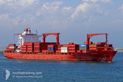
MARGARETE SCHULTE
Container Ship
Current Trip
| Time Travelled | 1 day |
|---|---|
| Remaining Time | 17 days |
| Distance Travelled | 420.17 nm |
| Remaining Distance | 5121.13 nm |
| AVG Speed | 13.8 Knopen |
| MAX Speed | 16.7 Knopen |
| AVG Wind | 21.1 knots |
| MAX Wind | 27 knots |
| MIN Temp | 7.2°C / 44.96°F |
| MAX Temp | 10.6°C / 51.08°F |
| Diepgang | 10.2 M |
| Positie ontvangen | 1 m geleden |
Current Position
| Lengtegraad | 0.18942° |
|---|---|
| Breedtegraat | 50.54583° |
| Status | Under way using engine |
| Snelheid | 13.5 Knopen |
| Koers | 257.6° |
| Gebied | English Channel |
| Station | T-AIS |
| Positie ontvangen | 1 m geleden |
Info
Information
The current position of MARGARETE SCHULTE is in English Channel with coordinates 50.54583° / 0.18942° as reported on 2024-04-19 17:51 by AIS to our vessel tracker app. The vessel's current speed is 13.5 Knopen and is heading at the port of VERACRUZ. The estimated time of arrival as calculated by MyShipTracking vessel tracking app is 2024-05-07 01:33 LT
The vessel MARGARETE SCHULTE (IMO: 9302944, MMSI: 249837000) is a Container Ship that was built in 2006 ( 18 Jaar oud ). It's sailing under the flag of [MT] Malta.
In this page you can find informations about the vessels current position, last detected port calls, and current voyage information. If the vessels is not in coverage by AIS you will find the latest position.
The current position of MARGARETE SCHULTE is detected by our AIS receivers and we are not responsible for the reliability of the data. The last position was recorded while the vessel was in Coverage by the Ais receivers of our vessel tracking app.
The current draught of MARGARETE SCHULTE as reported by AIS is 10.2 meters
Weather
| Temperature | 10.6°C / 51.08°F |
|---|---|
| Wind Speed | 15 knots |
| Direction | 31° NNE |
| Pressure | 1018.7 hPa |
| Humidity | 77.7 % |
| Cloud Coverage | 69 % |
Featured Company
Last Port Calls
| Port | Arrival | Departure | Time In Port |
|---|---|---|---|
| 2024-04-17 03:23 | 2024-04-18 11:11 | 1 d | |
| 2024-04-14 08:07 | 2024-04-16 01:37 | 1 d | |
| 2024-04-12 04:29 | 2024-04-13 11:06 | 1 d | |
| 2024-03-28 21:59 | 2024-03-30 03:21 | 1 d | |
| 2024-03-26 13:31 | 2024-03-26 22:51 | 9 h | |
| 2024-03-22 20:36 | 2024-03-23 11:45 | 15 h | |
| 2024-03-04 04:38 | 2024-03-04 21:30 | 16 h | |
| 2024-03-01 16:13 | 2024-03-03 06:34 | 1 d | |
| 2024-02-28 14:21 | 2024-02-29 17:08 | 1 d | |
| 2024-02-11 03:40 | 2024-02-12 00:44 | 21 h |
Most Visited Ports (Last year)
| Port | Arrivals | |
|---|---|---|
| 11 | ||
| 8 | ||
| 8 | ||
| 8 | ||
| 7 | ||
| 6 |
Last Trips
| Origin | Departure | Destination | Arrival | Distance | |
|---|---|---|---|---|---|
| 2024-04-16 03:37 | 2024-04-17 05:23 | 396.94 nm | |||
| 2024-04-13 12:06 | 2024-04-14 10:07 | 266.70 nm | |||
| 2024-03-29 22:21 | 2024-04-12 05:29 | 4919.35 nm | |||
| 2024-03-26 16:51 | 2024-03-28 16:59 | 822.45 nm | |||
| 2024-03-23 05:45 | 2024-03-26 07:31 | 1135.65 nm | |||
| 2024-03-04 22:30 | 2024-03-22 14:36 | 5841.38 nm | |||
| 2024-03-03 07:34 | 2024-03-04 05:38 | 367.00 nm | |||
| 2024-02-29 17:08 | 2024-03-01 17:13 | 281.76 nm | |||
| 2024-02-11 19:44 | 2024-02-28 14:21 | 4940.44 nm | |||
| 2024-02-02 10:01 | 2024-02-10 22:40 | 2004.90 nm |
Events
| Tijd | Evenement | Details | Positie / Bestemming | Info |
|---|---|---|---|---|
| 2024-04-19 13:32 | Wijzig zee gebeid | United Kingdom part of the English Channel United Kingdom part of the North Sea |
51.07445 / 1.48005
English Channel
MXVER
|
Snelheid: 14.6 kn Koers: 232.4° |
| 2024-04-19 11:06 | Draught Changed | 10.2 10.4 |
51.51733 / 2.04730
MXVER
|
Snelheid: 13.9 kn Koers: 219.9° |
| 2024-04-19 08:52 | Wijzig zee gebeid | United Kingdom part of the North Sea Dutch part of the North Sea |
51.91103 / 2.56627
North Sea
MXVER
|
Snelheid: 13.8 kn Koers: 220.3° |
| 2024-04-19 05:43 | Binnenbereik |
52.51248 / 3.32861
North Sea
MXVER
|
Snelheid: 14.9 kn Koers: 211.7° |
|
| 2024-04-19 04:29 | Buitenbereik |
52.73558 / 3.65473
North Sea
MXVER
|
Snelheid: 14.4 kn Koers: 223.2° |
|
| 2024-04-18 23:28 | Binnenbereik |
53.68394 / 4.70833
North Sea
MXVER
|
Snelheid: 13.9 kn Koers: 201.2° |
|
| 2024-04-18 19:54 | Buitenbereik |
54.13142 / 5.66025
North Sea
MXVER
|
Snelheid: 14 kn Koers: 261.6° |
|
| 2024-04-18 18:59 | Wijzig zee gebeid | Dutch part of the North Sea German part of the North Sea |
54.15718 / 6.01194
North Sea
MXVER
|
Snelheid: 13.2 kn Koers: 265.5° |
| 2024-04-18 11:11 | Vertrekhaven |
|
53.60498 / 8.50040
MXVER
|
Snelheid: 8.7 kn Koers: 320° |
| 2024-04-18 11:07 | Start beweging |
53.59882 / 8.50950
[DE] BREMERHAVEN
|
Snelheid: 3.4 kn Koers: 316° |