
LINTAN
Cargo
Current Trip
| Time Travelled | 19 days |
|---|---|
| Remaining Time | 2 days |
| Distance Travelled | 5042.09 nm |
| Remaining Distance | 676.20 nm |
| AVG Speed | 11 Knopen |
| MAX Speed | 14.3 Knopen |
| AVG Wind | 14.8 knots |
| MAX Wind | 26 knots |
| MIN Temp | 15.2°C / 59.36°F |
| MAX Temp | 28°C / 82.4°F |
| Diepgang | 10.3 M |
| Positie ontvangen | 1 m geleden |
Current Position
| Lengtegraad | -4.00792° |
|---|---|
| Breedtegraat | 36.15618° |
| Status | Under way using engine |
| Snelheid | 11.2 Knopen |
| Koers | 82.4° |
| Gebied | Alboran Sea |
| Station | T-AIS |
| Positie ontvangen | 1 m geleden |
Info
Information
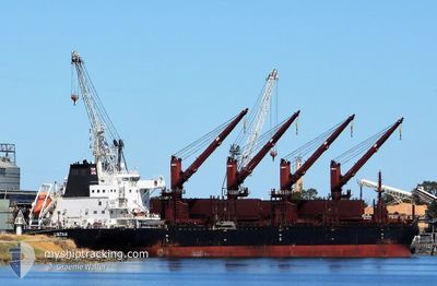
The current position of LINTAN is in Alboran Sea with coordinates 36.15618° / -4.00792° as reported on 2024-04-19 00:23 by AIS to our vessel tracker app. The vessel's current speed is 11.2 Knopen and is heading at the port of CAGLIARI. The estimated time of arrival as calculated by MyShipTracking vessel tracking app is 2024-04-21 04:44 LT
The vessel LINTAN (IMO: 9715206, MMSI: 477737100) is a Cargo It's sailing under the flag of [HK] Hong Kong.
In this page you can find informations about the vessels current position, last detected port calls, and current voyage information. If the vessels is not in coverage by AIS you will find the latest position.
The current position of LINTAN is detected by our AIS receivers and we are not responsible for the reliability of the data. The last position was recorded while the vessel was in Coverage by the Ais receivers of our vessel tracking app.
The current draught of LINTAN as reported by AIS is 10.3 meters
Weather
| Temperature | 17.7°C / 63.86°F |
|---|---|
| Wind Speed | 8 knots |
| Direction | 92° E |
| Pressure | 1017.4 hPa |
| Humidity | 84.7 % |
| Cloud Coverage | 100 % |
Featured Company
Last Port Calls
| Port | Arrival | Departure | Time In Port |
|---|---|---|---|
| 2024-03-15 07:20 | 2024-03-30 21:40 | 15 d | |
| 2024-02-22 02:19 | 2024-02-23 14:43 | 1 d | |
| 2024-02-19 16:44 | 2024-02-20 18:21 | 1 d |
Most Visited Ports (Last year)
| Port | Arrivals | |
|---|---|---|
| 2 | ||
| 1 | ||
| 1 | ||
| 1 | ||
| 1 | ||
| 1 |
Last Trips
| Origin | Departure | Destination | Arrival | Distance | |
|---|---|---|---|---|---|
| 2024-02-23 09:43 | 2024-03-15 02:20 | 1659.03 nm | |||
| 2024-02-20 13:21 | 2024-02-21 21:19 | 294.08 nm | |||
| 2024-01-30 09:52 | 2024-02-19 11:44 | 4937.84 nm |
Events
| Tijd | Evenement | Details | Positie / Bestemming | Info |
|---|---|---|---|---|
| 2024-04-18 23:02 | Status Changed | Under way using engine Default |
36.14447 / -4.34907
ITCAG
|
Snelheid: 12.3 kn Koers: 85° |
| 2024-04-18 22:40 | Status Changed | Default Under way using engine |
36.14046 / -4.43027
ITCAG
|
Snelheid: 12.1 kn Koers: 81.1° |
| 2024-04-18 22:09 | Status Changed | Under way using engine Default |
36.12798 / -4.56067
ITCAG
|
Snelheid: 11.9 kn Koers: 91° |
| 2024-04-18 22:04 | Status Changed | Default Under way using engine |
36.12833 / -4.57693
ITCAG
|
Snelheid: 12 kn Koers: 90.2° |
| 2024-04-18 20:47 | Wijzig zee gebeid | Spanish part of the Alboran Sea Gibraltarian part of the Alboran Sea |
36.08730 / -4.89762
Alboran Sea
ITCAG
|
Snelheid: 13.9 kn Koers: 79.4° |
| 2024-04-18 20:14 | Wijzig zee gebeid | Gibraltarian part of the Alboran Sea Spanish part of the Alboran Sea |
36.05722 / -5.05092
Alboran Sea
ITCAG
|
Snelheid: 13.8 kn Koers: 72.6° |
| 2024-04-18 19:13 | Wijzig zee gebeid | Spanish part of the Alboran Sea Spanish part of the Strait of Gibraltar |
35.99150 / -5.31848
Alboran Sea
ITCAG
|
Snelheid: 12.8 kn Koers: 72.4° |
| 2024-04-18 18:59 | Wijzig zee gebeid | Spanish part of the Strait of Gibraltar Moroccan part of the Strait of Gibraltar |
35.97622 / -5.37815
Strait of Gibraltar
ITCAG
|
Snelheid: 13 kn Koers: 72° |
| 2024-04-18 17:02 | Wijzig zee gebeid | Moroccan part of the Strait of Gibraltar Moroccan part of the North Atlantic Ocean |
35.89562 / -5.83957
Strait of Gibraltar
ITCAG
|
Snelheid: 11.5 kn Koers: 85.9° |
| 2024-04-18 17:01 | Status Changed | Under way using engine Default |
35.89540 / -5.84347
ITCAG
|
Snelheid: 11.5 kn Koers: 86° |