
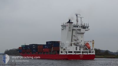
LINDA
Container Ship
Current Trip
| Time Travelled | 2 days |
|---|---|
| Remaining Time | 1 day |
| Distance Travelled | 878.07 nm |
| Remaining Distance | 669.10 nm |
| AVG Speed | 12.5 Knopen |
| MAX Speed | 15.4 Knopen |
| AVG Wind | 19.3 knots |
| MAX Wind | 32 knots |
| MIN Temp | 10.6°C / 51.08°F |
| MAX Temp | 19.1°C / 66.38°F |
| Diepgang | 7.7 M |
| Positie ontvangen | 1 d geleden |
Current Position
| Lengtegraad | -9.63040° |
|---|---|
| Breedtegraat | 43.39685° |
| Status | Under way using engine |
| Snelheid | 12.2 Knopen |
| Koers | 26.5° |
| Gebied | North Atlantic Ocean |
| Station | T-AIS |
| Positie ontvangen | 1 d geleden |
Info
Information
The current position of LINDA is in North Atlantic Ocean with coordinates 43.39685° / -9.63040° as reported on 2024-04-16 22:58 by AIS to our vessel tracker app. The vessel's current speed is 12.2 Knopen and is heading at the port of TILBURY. The estimated time of arrival as calculated by MyShipTracking vessel tracking app is 2024-04-19 06:47 LT
The vessel LINDA (IMO: 9354325, MMSI: 230984000) is a Container Ship that was built in 2007 ( 17 Jaar oud ). It's sailing under the flag of [FI] Finland.
In this page you can find informations about the vessels current position, last detected port calls, and current voyage information. If the vessels is not in coverage by AIS you will find the latest position.
The current position of LINDA is detected by our AIS receivers and we are not responsible for the reliability of the data. The last position was recorded while the vessel was in Coverage by the Ais receivers of our vessel tracking app.
The current draught of LINDA as reported by AIS is 7.7 meters
Weather
| Temperature | 11.3°C / 52.34°F |
|---|---|
| Wind Speed | 18 knots |
| Direction | 331° NNW |
| Pressure | 1020.6 hPa |
| Humidity | 88.5 % |
| Cloud Coverage | 11 % |
Featured Company
Last Port Calls
| Port | Arrival | Departure | Time In Port |
|---|---|---|---|
| 2024-04-14 17:08 | 2024-04-15 04:28 | 11 h | |
| 2024-04-14 05:03 | 2024-04-14 11:13 | 6 h | |
| 2024-04-12 15:46 | 2024-04-13 03:29 | 11 h | |
| 2024-04-07 05:34 | 2024-04-07 14:10 | 8 h | |
| 2024-04-06 17:51 | 2024-04-07 01:36 | 7 h | |
| 2024-03-30 18:20 | 2024-03-31 14:01 | 19 h | |
| 2024-03-28 04:04 | 2024-03-29 17:19 | 1 d | |
| 2024-03-26 00:41 | 2024-03-27 00:17 | 23 h | |
| 2024-03-21 13:54 | 2024-03-21 22:16 | 8 h | |
| 2024-03-20 18:27 | 2024-03-21 08:15 | 13 h |
Most Visited Ports (Last year)
| Port | Arrivals | |
|---|---|---|
| 17 | ||
| 16 | ||
| 16 | ||
| 14 | ||
| 14 | ||
| 14 |
Last Trips
| Origin | Departure | Destination | Arrival | Distance | |
|---|---|---|---|---|---|
| 2024-04-14 13:13 | 2024-04-14 19:08 | 49.66 nm | |||
| 2024-04-13 03:29 | 2024-04-14 07:03 | 201.99 nm | |||
| 2024-04-07 15:10 | 2024-04-12 15:46 | 562.97 nm | |||
| 2024-04-07 02:36 | 2024-04-07 06:34 | 55.19 nm | |||
| 2024-03-31 16:01 | 2024-04-06 18:51 | 1875.38 nm | |||
| 2024-03-29 18:19 | 2024-03-30 19:20 | 322.82 nm | |||
| 2024-03-27 00:17 | 2024-03-28 05:04 | 417.95 nm | |||
| 2024-03-21 23:16 | 2024-03-26 00:41 | 1280.48 nm | |||
| 2024-03-21 09:15 | 2024-03-21 14:54 | 54.77 nm | |||
| 2024-03-20 12:45 | 2024-03-20 19:27 | 92.96 nm |
Events
| Tijd | Evenement | Details | Positie / Bestemming | Info |
|---|---|---|---|---|
| 2024-04-16 23:05 | Status Changed | Default Under way using engine |
43.41877 / -9.61485
GBTIL
|
Snelheid: 12.2 kn Koers: 26.5° |
| 2024-04-16 22:58 | Buitenbereik |
43.39685 / -9.63040
North Atlantic Ocean
GBTIL
|
Snelheid: 12.2 kn Koers: 26.5° |
|
| 2024-04-16 22:56 | Status Changed | Under way using engine Default |
43.38980 / -9.63533
GBTIL
|
Snelheid: 12 kn Koers: 24° |
| 2024-04-16 22:47 | Status Changed | Default Under way using engine |
43.36390 / -9.65268
GBTIL
|
Snelheid: 12 kn Koers: 25.8° |
| 2024-04-16 20:17 | Status Changed | Under way using engine Default |
42.88592 / -9.78703
GBTIL
|
Snelheid: 12 kn Koers: 2° |
| 2024-04-16 20:05 | Binnenbereik |
42.88592 / -9.78703
North Atlantic Ocean
GBTIL
|
Snelheid: 11.4 kn Koers: 0.5° |
|
| 2024-04-16 15:08 | Status Changed | Default Under way using engine |
41.93400 / -9.77973
GBTIL
|
Snelheid: 10.1 kn Koers: 0.8° |
| 2024-04-16 15:02 | Wijzig zee gebeid | Spanish part of the North Atlantic Ocean Portuguese part of the North Atlantic Ocean |
41.91677 / -9.78003
North Atlantic Ocean
GBTIL
|
Snelheid: 10.1 kn Koers: 0.8° |
| 2024-04-16 15:02 | Status Changed | Under way using engine Default |
41.91677 / -9.78003
GBTIL
|
Snelheid: 10.8 kn Koers: 1° |
| 2024-04-16 15:02 | Buitenbereik |
41.91677 / -9.78003
North Atlantic Ocean
GBTIL
|
Snelheid: 10.1 kn Koers: 0.8° |