
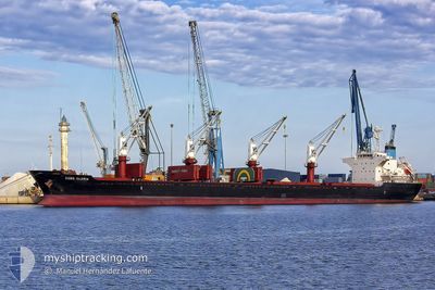
KOBE GLORIA
Bulk Carrier
Current Trip
| Time Travelled | 45 days |
|---|---|
| Remaining Time | --- |
| Distance Travelled | 6545.39 nm |
| Remaining Distance | --- |
| AVG Speed | 11.3 Knopen |
| MAX Speed | 16.9 Knopen |
| AVG Wind | 11.3 knots |
| MAX Wind | 29.7 knots |
| MIN Temp | 16.7°C / 62.06°F |
| MAX Temp | 30.8°C / 87.44°F |
| Diepgang | 7.1 M |
| Positie ontvangen | 1 d geleden |
Current Position
| Lengtegraad | 118.41482° |
|---|---|
| Breedtegraat | 23.62362° |
| Status | Under way using engine |
| Snelheid | 12.2 Knopen |
| Koers | 48.5° |
| Gebied | South China Sea |
| Station | T-AIS |
| Positie ontvangen | 1 d geleden |
Info
Information
The current position of KOBE GLORIA is in South China Sea with coordinates 23.62362° / 118.41482° as reported on 2024-04-21 15:16 by AIS to our vessel tracker app. The vessel's current speed is 12.2 Knopen and is heading at the port of HULUDAO. The estimated time of arrival as calculated by MyShipTracking vessel tracking app is 2024-04-26 01:00 LT
The vessel KOBE GLORIA (IMO: 9668324, MMSI: 352396000) is a Bulk Carrier that was built in 2013 ( 11 Jaar oud ). It's sailing under the flag of [PA] Panama.
In this page you can find informations about the vessels current position, last detected port calls, and current voyage information. If the vessels is not in coverage by AIS you will find the latest position.
The current position of KOBE GLORIA is detected by our AIS receivers and we are not responsible for the reliability of the data. The last position was recorded while the vessel was in Coverage by the Ais receivers of our vessel tracking app.
The current draught of KOBE GLORIA as reported by AIS is 7.1 meters
Weather
| Temperature | 16.3°C / 61.34°F |
|---|---|
| Wind Speed | 9 knots |
| Direction | 306° NW |
| Pressure | 1007.7 hPa |
| Humidity | 94.5 % |
| Cloud Coverage | 100 % |
Featured Company
Events
| Tijd | Evenement | Details | Positie / Bestemming | Info |
|---|---|---|---|---|
| 2024-04-21 15:33 | Status Changed | Default Under way using engine |
23.66052 / 118.47045
HULUDAO_CN
|
Snelheid: 12.2 kn Koers: 48.5° |
| 2024-04-21 15:16 | Buitenbereik |
23.62362 / 118.41482
South China Sea
HULUDAO_CN
|
Snelheid: 12.2 kn Koers: 48.5° |
|
| 2024-04-21 15:08 | Status Changed | Under way using engine Default |
23.60470 / 118.39147
HULUDAO_CN
|
Snelheid: 12.4 kn Koers: 49° |
| 2024-04-21 14:58 | Binnenbereik |
23.60697 / 118.39428
South China Sea
HULUDAO_CN
|
Snelheid: 12.3 kn Koers: 48.8° |
|
| 2024-04-21 14:05 | Status Changed | Default Under way using engine |
23.46754 / 118.21194
HULUDAO_CN
|
Snelheid: 13 kn Koers: 51.3° |
| 2024-04-21 14:00 | Buitenbereik |
23.45649 / 118.19709
South China Sea
HULUDAO_CN
|
Snelheid: 13 kn Koers: 51.3° |
|
| 2024-04-21 13:15 | Status Changed | Under way using engine Default |
23.35374 / 118.06102
HULUDAO_CN
|
Snelheid: 13.2 kn Koers: 50° |
| 2024-04-21 13:09 | Binnenbereik |
23.35524 / 118.06301
South China Sea
HULUDAO_CN
|
Snelheid: 13.1 kn Koers: 50.7° |
|
| 2024-04-20 16:47 | Status Changed | Default Under way using engine |
21.72041 / 114.01520
HULUDAO_CN
|
Snelheid: 10.9 kn Koers: 35.9° |
| 2024-04-20 16:43 | Buitenbereik |
21.71283 / 114.00596
South China Sea
HULUDAO_CN
|
Snelheid: 10.9 kn Koers: 35.9° |