
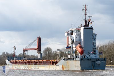
SIYANIE SEVERA
General Cargo
Current Trip
TO ORDER
| Time Travelled | 4 days |
|---|---|
| Remaining Time | --- |
| Distance Travelled | 205.59 nm |
| Remaining Distance | --- |
| AVG Speed | 9.6 Knopen |
| MAX Speed | 10.7 Knopen |
| AVG Wind | 12.8 knots |
| MAX Wind | 21.5 knots |
| MIN Temp | 17.3°C / 63.14°F |
| MAX Temp | 28.4°C / 83.12°F |
| Diepgang | 5.3 M |
| Positie ontvangen | 1 m geleden |
Current Position
| Lengtegraad | 28.38685° |
|---|---|
| Breedtegraat | 33.92313° |
| Status | Under way using engine |
| Snelheid | 10.5 Knopen |
| Koers | 336.6° |
| Gebied | Mediterranean Sea - Eastern Basin |
| Station | T-AIS |
| Positie ontvangen | 1 m geleden |
Info
Information
The current position of SIYANIE SEVERA is in Mediterranean Sea - Eastern Basin with coordinates 33.92313° / 28.38685° as reported on 2024-04-25 09:10 by AIS to our vessel tracker app. The vessel's current speed is 10.5 Knopen
The vessel SIYANIE SEVERA (IMO: 9250385, MMSI: 273398650) is a General Cargo that was built in 2002 ( 22 Jaar oud ). It's sailing under the flag of [RU] Russia.
In this page you can find informations about the vessels current position, last detected port calls, and current voyage information. If the vessels is not in coverage by AIS you will find the latest position.
The current position of SIYANIE SEVERA is detected by our AIS receivers and we are not responsible for the reliability of the data. The last position was recorded while the vessel was in Coverage by the Ais receivers of our vessel tracking app.
The current draught of SIYANIE SEVERA as reported by AIS is 5.3 meters
Weather
| Temperature | 18.7°C / 65.66°F |
|---|---|
| Wind Speed | 9 knots |
| Direction | 296° WNW |
| Pressure | 1009.2 hPa |
| Humidity | 77 % |
| Cloud Coverage | 100 % |
Featured Company
Last Port Calls
| Port | Arrival | Departure | Time In Port |
|---|---|---|---|
| 2024-04-18 12:03 | 2024-04-20 09:28 | 1 d | |
| 2024-04-15 23:59 | 2024-04-16 16:48 | 16 h | |
| 2024-02-22 01:19 |
Most Visited Ports (Last year)
| Port | Arrivals | |
|---|---|---|
| 4 | ||
| 3 | ||
| 2 | ||
| 2 | ||
| 1 | ||
| 1 |
Last Trips
| Origin | Departure | Destination | Arrival | Distance | |
|---|---|---|---|---|---|
| 2024-04-16 18:48 | 2024-04-18 14:03 | 18.61 nm | |||
| 2024-02-22 04:19 | 2024-04-16 01:59 | 1104.42 nm |
Events
| Tijd | Evenement | Details | Positie / Bestemming | Info |
|---|---|---|---|---|
| 2024-04-25 06:05 | Wijzig zee gebeid | Greek part of the Mediterranean Sea - Eastern Basin Egyptian part of the Mediterranean Sea - Eastern Basin |
33.45398 / 28.62772
Mediterranean Sea - Eastern Basin
TO ORDER
|
Snelheid: 9.7 kn Koers: 335.2° |
| 2024-04-25 03:00 | Status Changed | Under way using engine Default |
32.98522 / 28.87545
TO ORDER
|
Snelheid: 9 kn Koers: 337° |
| 2024-04-25 02:52 | Binnenbereik |
32.98900 / 28.87343
Mediterranean Sea - Eastern Basin
TO ORDER
|
Snelheid: 10.1 kn Koers: 335.8° |
|
| 2024-04-25 00:56 | Status Changed | Default Under way using engine |
32.65957 / 29.03063
TO ORDER
|
Snelheid: 10 kn Koers: 337.8° |
| 2024-04-25 00:52 | Buitenbereik |
32.64977 / 29.03568
Mediterranean Sea - Eastern Basin
TO ORDER
|
Snelheid: 10 kn Koers: 337.8° |
|
| 2024-04-25 00:42 | Status Changed | Under way using engine Default |
32.62355 / 29.04632
TO ORDER
|
Snelheid: 9 kn Koers: 341° |
| 2024-04-25 00:37 | Status Changed | Default Under way using engine |
32.60833 / 29.05167
TO ORDER
|
Snelheid: 9.7 kn Koers: 342.7° |
| 2024-04-25 00:27 | Status Changed | Under way using engine Default |
32.58245 / 29.06280
TO ORDER
|
Snelheid: 10.1 kn Koers: 335° |
| 2024-04-24 23:53 | Status Changed | Default Under way using engine |
32.49575 / 29.10953
TO ORDER
|
Snelheid: 9.9 kn Koers: 334.5° |
| 2024-04-24 23:48 | Status Changed | Under way using engine Default |
32.48330 / 29.11645
TO ORDER
|
Snelheid: 9.6 kn Koers: 336° |