
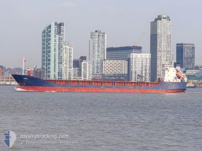
KAILI
General Cargo
Current Trip
| Time Travelled | 1 h, 25 mins |
|---|---|
| Remaining Time | --- |
| Distance Travelled | 17.04 nm |
| Remaining Distance | --- |
| AVG Speed | 12.1 Knopen |
| MAX Speed | 14.2 Knopen |
| AVG Wind | 18.4 knots |
| MAX Wind | 19 knots |
| MIN Temp | 8°C / 46.4°F |
| MAX Temp | 8.6°C / 47.48°F |
| Diepgang | 6 M |
| Positie ontvangen | Nu |
Current Position
| Lengtegraad | 3.37220° |
|---|---|
| Breedtegraat | 51.61310° |
| Status | Under way using engine |
| Snelheid | 11.4 Knopen |
| Koers | 331.4° |
| Gebied | North Sea |
| Station | T-AIS |
| Positie ontvangen | Nu |
Info
Information
The current position of KAILI is in North Sea with coordinates 51.61310° / 3.37220° as reported on 2024-04-24 17:51 by AIS to our vessel tracker app. The vessel's current speed is 11.4 Knopen and is heading at the port of UDDEVALLA. The estimated time of arrival as calculated by MyShipTracking vessel tracking app is 2024-04-26 15:00 LT
The vessel KAILI (IMO: 9114737, MMSI: 256295000) is a General Cargo that was built in 1996 ( 28 Jaar oud ). It's sailing under the flag of [MT] Malta.
In this page you can find informations about the vessels current position, last detected port calls, and current voyage information. If the vessels is not in coverage by AIS you will find the latest position.
The current position of KAILI is detected by our AIS receivers and we are not responsible for the reliability of the data. The last position was recorded while the vessel was in Coverage by the Ais receivers of our vessel tracking app.
The current draught of KAILI as reported by AIS is 6 meters
Weather
| Temperature | 8°C / 46.4°F |
|---|---|
| Wind Speed | 19 knots |
| Direction | 335° NNW |
| Pressure | 1011.1 hPa |
| Humidity | 67.8 % |
| Cloud Coverage | 88 % |
Featured Company
Last Port Calls
| Port | Arrival | Departure | Time In Port |
|---|---|---|---|
| 2024-04-23 21:54 | 2024-04-24 16:26 | 18 h | |
| 2024-04-22 01:30 | 2024-04-22 21:07 | 19 h | |
| 2024-04-17 13:20 | 2024-04-17 22:49 | 9 h | |
| 2024-04-11 18:24 | 2024-04-16 10:30 | 4 d | |
| 2024-04-08 06:24 | 2024-04-10 15:27 | 2 d | |
| 2024-04-06 02:09 | 2024-04-06 02:21 | 11 m | |
| 2024-04-04 20:46 | 2024-04-06 01:20 | 1 d | |
| 2024-04-04 19:55 | 2024-04-04 19:59 | 3 m | |
| 2024-04-02 23:09 | 2024-04-04 07:49 | 1 d | |
| 2024-03-20 11:42 | 2024-03-20 11:48 | 6 m |
Last Trips
| Origin | Departure | Destination | Arrival | Distance | |
|---|---|---|---|---|---|
| 2024-04-22 23:07 | 2024-04-23 23:54 | 105.31 nm | |||
| 2024-04-18 01:49 | 2024-04-22 03:30 | 1028.42 nm | |||
| 2024-04-16 12:30 | 2024-04-17 16:20 | 335.62 nm | |||
| 2024-04-10 17:27 | 2024-04-11 20:24 | 303.90 nm | |||
| 2024-04-06 05:21 | 2024-04-08 08:24 | 525.90 nm | |||
| 2024-04-06 04:20 | 2024-04-06 05:09 | 3.28 nm | |||
| 2024-04-04 22:59 | 2024-04-04 23:46 | 4.42 nm | |||
| 2024-04-04 10:49 | 2024-04-04 22:55 | 130.82 nm | |||
| 2024-03-20 12:48 | 2024-04-03 02:09 | 1503.25 nm | |||
| 2024-03-20 11:22 | 2024-03-20 12:42 | 6.34 nm |
Events
| Tijd | Evenement | Details | Positie / Bestemming | Info |
|---|---|---|---|---|
| 2024-04-24 17:14 | Start beweging | 6.26 nm, West of MIDDELBURG |
51.50992 / 3.45091
UDDEVALLA
|
Snelheid: 12.9 kn Koers: 311.2° |
| 2024-04-24 17:14 | Stop beweging | 6.14 nm, West of MIDDELBURG |
51.50834 / 3.45378
UDDEVALLA
|
Snelheid: Koers: 0° |
| 2024-04-24 16:56 | Start beweging | 2.84 nm, West of VLISSINGEN STATION |
51.46175 / 3.51849
UDDEVALLA
|
Snelheid: 12.2 kn Koers: 332.8° |
| 2024-04-24 16:53 | Stop beweging | 2.54 nm, West of VLISSINGEN STATION |
51.45504 / 3.52394
UDDEVALLA
|
Snelheid: Koers: 0° |
| 2024-04-24 16:53 | Start beweging | 2.48 nm, West of VLISSINGEN STATION |
51.45390 / 3.52527
UDDEVALLA
|
Snelheid: 12 kn Koers: 312° |
| 2024-04-24 16:52 | Stop beweging | 2.38 nm, West of VLISSINGEN STATION |
51.45266 / 3.52762
UDDEVALLA
|
Snelheid: Koers: 0° |
| 2024-04-24 16:49 | Start beweging | 1.8 nm, West of VLISSINGEN STATION |
51.44901 / 3.54271
UDDEVALLA
|
Snelheid: 12.5 kn Koers: 289.1° |
| 2024-04-24 16:49 | Stop beweging | 1.6 nm, West of VLISSINGEN STATION |
51.44785 / 3.54794
UDDEVALLA
|
Snelheid: Koers: 0° |
| 2024-04-24 16:46 | Start beweging | 1.1 nm, West of VLISSINGEN STATION |
51.44337 / 3.56190
UDDEVALLA
|
Snelheid: 12.1 kn Koers: 306.6° |
| 2024-04-24 16:45 | Stop beweging | 1.03 nm, West of VLISSINGEN STATION |
51.44222 / 3.56435
UDDEVALLA
|
Snelheid: Koers: 0° |