
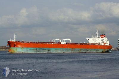
AFRAGOLD
Crude Oil Tanker
Current Trip
| Time Travelled | --- |
|---|---|
| Remaining Time | --- |
| Distance Travelled | 1023.22 nm |
| Remaining Distance | 13.43 nm |
| AVG Speed | 10.3 Knopen |
| MAX Speed | 15.6 Knopen |
| AVG Wind | 9.1 knots |
| MAX Wind | 22.8 knots |
| MIN Temp | 20°C / 68°F |
| MAX Temp | 31.7°C / 89.06°F |
| Diepgang | 8.5 M |
| Positie ontvangen | 5 m geleden |
Current Position
| Lengtegraad | 56.57595° |
|---|---|
| Breedtegraat | 25.28998° |
| Status | At anchor |
| Snelheid | |
| Koers | 28° |
| Gebied | Gulf of Oman |
| Station | T-AIS |
| Positie ontvangen | 5 m geleden |
Info
Information
The current position of AFRAGOLD is in Gulf of Oman with coordinates 25.28998° / 56.57595° as reported on 2024-04-25 11:25 by AIS to our vessel tracker app. The vessel's current speed is 0 Knopen and is heading at the port of FUJAIRAH. The estimated time of arrival as calculated by MyShipTracking vessel tracking app is 2024-04-19 06:00 LT
The vessel AFRAGOLD (IMO: 9436018, MMSI: 636017796) is a Crude Oil Tanker that was built in 2009 ( 15 Jaar oud ). It's sailing under the flag of [LR] Liberia.
In this page you can find informations about the vessels current position, last detected port calls, and current voyage information. If the vessels is not in coverage by AIS you will find the latest position.
The current position of AFRAGOLD is detected by our AIS receivers and we are not responsible for the reliability of the data. The last position was recorded while the vessel was in Coverage by the Ais receivers of our vessel tracking app.
The current draught of AFRAGOLD as reported by AIS is 8.5 meters
Weather
| Temperature | 26°C / 78.8°F |
|---|---|
| Wind Speed | 12 knots |
| Direction | 43° NE |
| Pressure | 1006 hPa |
| Humidity | 68.9 % |
| Cloud Coverage | --- |
Featured Company
Last Port Calls
| Port | Arrival | Departure | Time In Port |
|---|---|---|---|
| 2024-02-19 11:57 | 2024-02-19 15:59 | 4 h | |
| 2024-02-01 04:08 |
Last Trips
| Origin | Departure | Destination | Arrival | Distance | |
|---|---|---|---|---|---|
| 2024-02-01 07:08 | 2024-02-19 13:57 | 4861.13 nm |
Events
| Tijd | Evenement | Details | Positie / Bestemming | Info |
|---|---|---|---|---|
| 2024-04-25 04:15 | Status Changed | At anchor Default |
25.29387 / 56.57727
AEFJR
|
Snelheid: Koers: 198° |
| 2024-04-25 04:10 | Status Changed | Default At anchor |
25.29388 / 56.57740
AEFJR
|
Snelheid: Koers: 198° |
| 2024-04-24 17:43 | Status Changed | At anchor Default |
25.29407 / 56.57670
AEFJR
|
Snelheid: Koers: 178° |
| 2024-04-24 17:39 | Status Changed | Default At anchor |
25.29408 / 56.57675
AEFJR
|
Snelheid: Koers: 181° |
| 2024-04-24 07:04 | Status Changed | At anchor Default |
25.29208 / 56.57935
AEFJR
|
Snelheid: Koers: 270° |
| 2024-04-24 06:58 | Status Changed | Default At anchor |
25.29215 / 56.57935
AEFJR
|
Snelheid: Koers: 271° |
| 2024-04-23 06:09 | Status Changed | At anchor Default |
25.29397 / 56.57670
AEFJR
|
Snelheid: 0.1 kn Koers: 167° |
| 2024-04-23 06:07 | Status Changed | Default At anchor |
25.29398 / 56.57678
AEFJR
|
Snelheid: 0.1 kn Koers: 171° |
| 2024-04-23 01:46 | Status Changed | At anchor Default |
25.29435 / 56.57715
AEFJR
|
Snelheid: Koers: 186° |
| 2024-04-23 01:43 | Status Changed | Default At anchor |
25.29438 / 56.57713
AEFJR
|
Snelheid: Koers: 183° |