
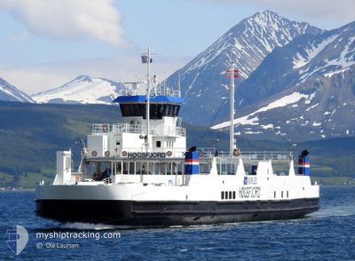
HOEGSFJORD
Ro-Ro/Passenger Ship
Current Trip
SOVIK-BRASOY
| Time Travelled | --- |
|---|---|
| Remaining Time | --- |
| Distance Travelled | 3817.96 nm |
| Remaining Distance | --- |
| AVG Speed | 10.6 Knopen |
| MAX Speed | 13.1 Knopen |
| AVG Wind | 12.4 knots |
| MAX Wind | 31.8 knots |
| MIN Temp | -6.3°C / 20.66°F |
| MAX Temp | 7.3°C / 45.14°F |
| Diepgang | 3.4 M |
| Positie ontvangen | 1 m geleden |
Current Position
| Lengtegraad | 12.28688° |
|---|---|
| Breedtegraat | 65.96920° |
| Status | Moored |
| Snelheid | |
| Koers | 187° |
| Gebied | Norwegian Sea |
| Station | T-AIS |
| Positie ontvangen | 1 m geleden |
Info
Information
The current position of HOEGSFJORD is in Norwegian Sea with coordinates 65.96920° / 12.28688° as reported on 2024-04-25 21:06 by AIS to our vessel tracker app. The vessel's current speed is 0 Knopen
The vessel HOEGSFJORD (IMO: 9055759, MMSI: 257288400) is a Ro-Ro/Passenger Ship that was built in 1992 ( 32 Jaar oud ). It's sailing under the flag of [NO] Norway.
In this page you can find informations about the vessels current position, last detected port calls, and current voyage information. If the vessels is not in coverage by AIS you will find the latest position.
The current position of HOEGSFJORD is detected by our AIS receivers and we are not responsible for the reliability of the data. The last position was recorded while the vessel was in Coverage by the Ais receivers of our vessel tracking app.
The current draught of HOEGSFJORD as reported by AIS is 3.4 meters
Weather
| Temperature | 5.2°C / 41.36°F |
|---|---|
| Wind Speed | 12 knots |
| Direction | 109° ESE |
| Pressure | 1009 hPa |
| Humidity | 71 % |
| Cloud Coverage | 24 % |
Featured Company
Last Port Calls
Most Visited Ports (Last year)
| Port | Arrivals | |
|---|---|---|
| 4 |
Last Trips
| Origin | Departure | Destination | Arrival | Distance |
|---|
Events
| Tijd | Evenement | Details | Positie / Bestemming | Info |
|---|---|---|---|---|
| 2024-04-25 17:03 | Status Changed | Moored Under way using engine |
65.96922 / 12.28687
SOVIK-BRASOY
|
Snelheid: Koers: 187° |
| 2024-04-25 16:57 | Stop beweging | 9.35 nm, West of SANDNESSJOEN |
65.96923 / 12.28687
SOVIK-BRASOY
|
Snelheid: 0.1 kn Koers: 187° |
| 2024-04-25 16:30 | Start beweging | 7.84 nm, South West of SANDNESSJOEN |
65.93172 / 12.42057
SOVIK-BRASOY
|
Snelheid: 11.8 kn Koers: 303.8° |
| 2024-04-25 16:24 | Stop beweging | 7.82 nm, South West of SANDNESSJOEN |
65.92708 / 12.43442
SOVIK-BRASOY
|
Snelheid: Koers: 305° |
| 2024-04-25 15:58 | Start beweging | 9.27 nm, South West of SANDNESSJOEN |
65.96588 / 12.29377
SOVIK-BRASOY
|
Snelheid: 8.7 kn Koers: 137.4° |
| 2024-04-25 15:45 | Stop beweging | 9.34 nm, West of SANDNESSJOEN |
65.96798 / 12.28822
SOVIK-BRASOY
|
Snelheid: 0.3 kn Koers: 307° |
| 2024-04-25 15:18 | Start beweging | 12.96 nm, South West of SANDNESSJOEN |
65.91387 / 12.19083
SOVIK-BRASOY
|
Snelheid: 8.5 kn Koers: 105.8° |
| 2024-04-25 15:12 | Stop beweging | 13.11 nm, South West of SANDNESSJOEN |
65.91398 / 12.18365
SOVIK-BRASOY
|
Snelheid: Koers: 304° |
| 2024-04-25 14:47 | Start beweging | 9.31 nm, South West of SANDNESSJOEN |
65.96397 / 12.29380
SOVIK-BRASOY
|
Snelheid: 11.5 kn Koers: 175.9° |
| 2024-04-25 14:41 | Stop beweging | 9.35 nm, West of SANDNESSJOEN |
65.96922 / 12.28687
SOVIK-BRASOY
|
Snelheid: Koers: 186° |