
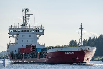
HJORDIS
General Cargo
Current Trip
| Time Travelled | 2 days |
|---|---|
| Remaining Time | 2 days |
| Distance Travelled | 812.80 nm |
| Remaining Distance | 681.54 nm |
| AVG Speed | 13.2 Knopen |
| MAX Speed | 18.3 Knopen |
| AVG Wind | 9.1 knots |
| MAX Wind | 17.9 knots |
| MIN Temp | 2.9°C / 37.22°F |
| MAX Temp | 8.9°C / 48.02°F |
| Diepgang | 7.1 M |
| Positie ontvangen | Nu |
Current Position
| Lengtegraad | 16.32869° |
|---|---|
| Breedtegraat | 55.91973° |
| Status | Under way using engine |
| Snelheid | 9.5 Knopen |
| Koers | 59.9° |
| Gebied | Baltic Sea |
| Station | T-AIS |
| Positie ontvangen | Nu |
Info
Information
The current position of HJORDIS is in Baltic Sea with coordinates 55.91973° / 16.32869° as reported on 2024-04-19 13:37 by AIS to our vessel tracker app. The vessel's current speed is 9.5 Knopen and is heading at the port of ROYTTA. The estimated time of arrival as calculated by MyShipTracking vessel tracking app is 2024-04-22 08:32 LT
The vessel HJORDIS (IMO: 9126235, MMSI: 230351000) is a General Cargo that was built in 1996 ( 28 Jaar oud ). It's sailing under the flag of [FI] Finland.
In this page you can find informations about the vessels current position, last detected port calls, and current voyage information. If the vessels is not in coverage by AIS you will find the latest position.
The current position of HJORDIS is detected by our AIS receivers and we are not responsible for the reliability of the data. The last position was recorded while the vessel was in Coverage by the Ais receivers of our vessel tracking app.
The current draught of HJORDIS as reported by AIS is 7.1 meters
Weather
| Temperature | 2.9°C / 37.22°F |
|---|---|
| Wind Speed | 15 knots |
| Direction | 64° ENE |
| Pressure | 1004.6 hPa |
| Humidity | 83 % |
| Cloud Coverage | 100 % |
Featured Company
Last Port Calls
| Port | Arrival | Departure | Time In Port |
|---|---|---|---|
| 2024-04-14 04:00 | 2024-04-16 21:09 | 2 d | |
| 2024-04-14 03:21 | 2024-04-14 03:35 | 14 m | |
| 2024-03-14 13:23 | 2024-04-09 08:25 | 25 d | |
| 2024-03-08 04:25 | 2024-03-09 12:10 | 1 d | |
| 2024-03-07 20:08 | 2024-03-07 21:21 | 1 h | |
| 2024-03-07 04:39 | 2024-03-07 19:36 | 14 h | |
| 2024-03-07 04:10 | 2024-03-07 04:31 | 20 m | |
| 2024-03-05 23:55 | 2024-03-06 01:23 | 1 h | |
| 2024-03-05 14:41 | 2024-03-05 15:50 | 1 h | |
| 2024-02-28 03:34 | 2024-03-02 20:20 | 3 d |
Last Trips
| Origin | Departure | Destination | Arrival | Distance | |
|---|---|---|---|---|---|
| 2024-04-14 05:35 | 2024-04-14 06:00 | 1.42 nm | |||
| 2024-04-09 11:25 | 2024-04-14 05:21 | 1506.45 nm | |||
| 2024-03-09 13:10 | 2024-03-14 15:23 | 1509.40 nm | |||
| 2024-03-07 22:21 | 2024-03-08 05:25 | 99.07 nm | |||
| 2024-03-07 20:36 | 2024-03-07 21:08 | 2.21 nm | |||
| 2024-03-07 05:31 | 2024-03-07 05:39 | 1.10 nm | |||
| 2024-03-06 02:23 | 2024-03-07 05:10 | 322.96 nm | |||
| 2024-03-05 16:50 | 2024-03-06 00:55 | 49.30 nm | |||
| 2024-03-02 22:20 | 2024-03-05 15:41 | 969.82 nm | |||
| 2024-02-21 18:45 | 2024-02-28 05:34 | 1519.37 nm |
Events
| Tijd | Evenement | Details | Positie / Bestemming | Info |
|---|---|---|---|---|
| 2024-04-19 09:58 | Wijzig zee gebeid | Swedish part of the Baltic Sea Danish part of the Kattegat |
55.62139 / 15.37472
Baltic Sea
FITOR
|
Snelheid: 10.3 kn Koers: 66.2° |
| 2024-04-19 05:37 | Wijzig zee gebeid | Danish part of the Kattegat Swedish part of the Baltic Sea |
55.19101 / 14.30151
Kattegat
FITOR
|
Snelheid: 10.7 kn Koers: 70.3° |
| 2024-04-19 00:20 | Wijzig zee gebeid | Swedish part of the Baltic Sea Danish part of the Baltic Sea |
55.29026 / 12.66617
Baltic Sea
FITOR
|
Snelheid: 10.7 kn Koers: 108.7° |
| 2024-04-19 00:05 | Wijzig zee gebeid | Danish part of the Baltic Sea Danish part of the Kattegat |
55.32026 / 12.62938
Baltic Sea
FITOR
|
Snelheid: 10.5 kn Koers: 186.3° |
| 2024-04-18 23:55 | Wijzig zee gebeid | Danish part of the Kattegat Swedish part of the Kattegat |
55.34932 / 12.63632
Kattegat
FITOR
|
Snelheid: 10.7 kn Koers: 192.8° |
| 2024-04-18 23:14 | Wijzig zee gebeid | Swedish part of the Kattegat Danish part of the Kattegat |
55.46628 / 12.68591
Kattegat
FITOR
|
Snelheid: 10.7 kn Koers: 191.1° |
| 2024-04-18 20:47 | Wijzig zee gebeid | Danish part of the Kattegat Swedish part of the Kattegat |
55.94144 / 12.65319
Kattegat
FITOR
|
Snelheid: 13.7 kn Koers: 193.4° |
| 2024-04-18 20:26 | Wijzig zee gebeid | Swedish part of the Kattegat Danish part of the Kattegat |
56.01829 / 12.65967
Kattegat
FITOR
|
Snelheid: 13.4 kn Koers: 158.5° |
| 2024-04-18 19:19 | Wijzig zee gebeid | Danish part of the Kattegat Swedish part of the Kattegat |
56.19997 / 12.38538
Kattegat
FITOR
|
Snelheid: 12.3 kn Koers: 163.8° |
| 2024-04-18 12:59 | Gevonden in zee | Swedish part of the Kattegat |
57.54789 / 11.31145
Kattegat
FITOR
|
Snelheid: 14.2 kn Koers: 136.8° |