
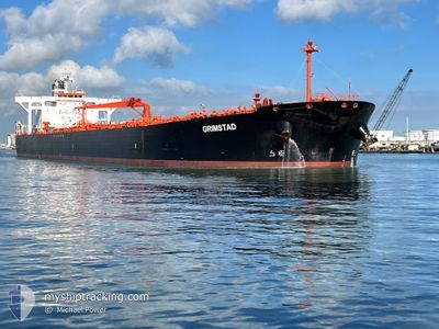
GRIMSTAD
Crude Oil Tanker
Current Trip
| Time Travelled | 15 days |
|---|---|
| Remaining Time | --- |
| Distance Travelled | 1729.17 nm |
| Remaining Distance | --- |
| AVG Speed | 10 Knopen |
| MAX Speed | 13.8 Knopen |
| AVG Wind | 13 knots |
| MAX Wind | 28.4 knots |
| MIN Temp | 9.4°C / 48.92°F |
| MAX Temp | 24.5°C / 76.1°F |
| Diepgang | 11.8 M |
| Positie ontvangen | 1 m geleden |
Current Position
| Lengtegraad | 23.08351° |
|---|---|
| Breedtegraat | 37.89628° |
| Status | At anchor |
| Snelheid | |
| Koers | 327° |
| Gebied | Aegean Sea |
| Station | T-AIS |
| Positie ontvangen | 1 m geleden |
Info
Information
The current position of GRIMSTAD is in Aegean Sea with coordinates 37.89628° / 23.08351° as reported on 2024-04-25 10:27 by AIS to our vessel tracker app. The vessel's current speed is 0 Knopen
The vessel GRIMSTAD (IMO: 9336402, MMSI: 309518000) is a Crude Oil Tanker that was built in 2007 ( 17 Jaar oud ). It's sailing under the flag of [BS] Bahamas.
In this page you can find informations about the vessels current position, last detected port calls, and current voyage information. If the vessels is not in coverage by AIS you will find the latest position.
The current position of GRIMSTAD is detected by our AIS receivers and we are not responsible for the reliability of the data. The last position was recorded while the vessel was in Coverage by the Ais receivers of our vessel tracking app.
The current draught of GRIMSTAD as reported by AIS is 11.8 meters
Weather
| Temperature | 18.6°C / 65.48°F |
|---|---|
| Wind Speed | 15 knots |
| Direction | 279° W |
| Pressure | 1006 hPa |
| Humidity | 43.4 % |
| Cloud Coverage | 49 % |
Featured Company
Most Visited Ports (Last year)
| Port | Arrivals | |
|---|---|---|
| 4 | ||
| 2 | ||
| 2 | ||
| 1 | ||
| 1 | ||
| 1 |
Events
| Tijd | Evenement | Details | Positie / Bestemming | Info |
|---|---|---|---|---|
| 2024-04-19 04:53 | Status Changed | At anchor Under way using engine |
37.89740 / 23.08462
GRAGT
|
Snelheid: Koers: 284° |
| 2024-04-18 20:02 | Stop beweging | 1.06 nm, South of AGIOI THEODORI |
37.89843 / 23.08327
GRAGT
|
Snelheid: 0.3 kn Koers: 290° |
| 2024-04-18 13:03 | ETA Changed | 2024/04/18 19:30 2024/04/18 22:00 |
37.31949 / 23.72618
GRAGT
|
Snelheid: 13 kn Koers: 2.7° |
| 2024-04-18 09:05 | Draught Changed | 11.8 8.5 |
36.52998 / 23.50729
GRAGT
|
Snelheid: 12.6 kn Koers: 29.7° |
| 2024-04-18 09:05 | Destination Changed | GRAGT LY LMQ |
36.52998 / 23.50729
GRAGT
|
Snelheid: 12.6 kn Koers: 29.7° |
| 2024-04-18 09:05 | ETA Changed | 2024/04/18 22:00 2024/04/14 21:00 |
36.52998 / 23.50729
GRAGT
|
Snelheid: 12.6 kn Koers: 29.7° |
| 2024-04-18 09:00 | Binnenbereik |
36.51495 / 23.49627
Aegean Sea
|
Snelheid: 12.5 kn Koers: 30.8° |
|
| 2024-04-18 07:34 | Status Changed | Default Under way using engine |
36.26001 / 23.30350
LY LMQ
|
Snelheid: 12.4 kn Koers: 31.9° |
| 2024-04-18 07:30 | Buitenbereik |
36.24767 / 23.29415
Aegean Sea
|
Snelheid: 12.4 kn Koers: 31.9° |
|
| 2024-04-18 07:07 | Wijzig zee gebeid | Greek part of the Aegean Sea Libyan part of the Mediterranean Sea - Eastern Basin |
36.17816 / 23.24416
Aegean Sea
|
Snelheid: 12.4 kn Koers: 29.4° |