
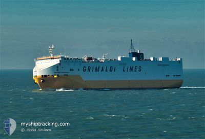
GRANDE SCANDINAVIA
Vehicles Carrier
Current Trip
| Time Travelled | 1 day |
|---|---|
| Remaining Time | --- |
| Distance Travelled | 542.75 nm |
| Remaining Distance | --- |
| AVG Speed | 16.9 Knopen |
| MAX Speed | 18 Knopen |
| AVG Wind | 18.9 knots |
| MAX Wind | 27.9 knots |
| MIN Temp | 15.4°C / 59.72°F |
| MAX Temp | 20.4°C / 68.72°F |
| Diepgang | 8.2 M |
| Positie ontvangen | Nu |
Current Position
| Lengtegraad | 26.17859° |
|---|---|
| Breedtegraat | 37.30276° |
| Status | Under way using engine |
| Snelheid | 16.3 Knopen |
| Koers | 306° |
| Gebied | Aegean Sea |
| Station | T-AIS |
| Positie ontvangen | Nu |
Info
Information
The current position of GRANDE SCANDINAVIA is in Aegean Sea with coordinates 37.30276° / 26.17859° as reported on 2024-04-20 00:50 by AIS to our vessel tracker app. The vessel's current speed is 16.3 Knopen and is heading at the port of IZMIT. The estimated time of arrival as calculated by MyShipTracking vessel tracking app is 2024-04-21 00:00 LT
The vessel GRANDE SCANDINAVIA (IMO: 9220615, MMSI: 247018700) is a Vehicles Carrier that was built in 2001 ( 23 Jaar oud ). It's sailing under the flag of [IT] Italy.
In this page you can find informations about the vessels current position, last detected port calls, and current voyage information. If the vessels is not in coverage by AIS you will find the latest position.
The current position of GRANDE SCANDINAVIA is detected by our AIS receivers and we are not responsible for the reliability of the data. The last position was recorded while the vessel was in Coverage by the Ais receivers of our vessel tracking app.
The current draught of GRANDE SCANDINAVIA as reported by AIS is 8.2 meters
Weather
| Temperature | 15.4°C / 59.72°F |
|---|---|
| Wind Speed | 26 knots |
| Direction | 240° WSW |
| Pressure | 1003 hPa |
| Humidity | 81.1 % |
| Cloud Coverage | 92 % |
Featured Company
Last Port Calls
| Port | Arrival | Departure | Time In Port |
|---|---|---|---|
| 2024-04-17 21:12 | 2024-04-18 15:37 | 18 h | |
| 2024-04-13 15:32 | 2024-04-14 20:05 | 1 d | |
| 2024-04-04 09:56 | 2024-04-05 11:56 | 1 d | |
| 2024-03-30 08:15 | 2024-03-31 15:09 | 1 d | |
| 2024-03-28 14:12 | 2024-03-29 02:49 | 12 h | |
| 2024-03-26 19:48 | 2024-03-27 15:10 | 19 h | |
| 2024-03-25 03:08 | 2024-03-26 04:07 | 1 d | |
| 2024-03-19 02:01 | 2024-03-20 19:59 | 1 d | |
| 2024-03-18 11:45 | 2024-03-19 00:45 | 12 h | |
| 2024-03-13 11:01 | 2024-03-14 06:16 | 19 h |
Last Trips
| Origin | Departure | Destination | Arrival | Distance | |
|---|---|---|---|---|---|
| 2024-04-14 22:05 | 2024-04-18 00:12 | 1245.20 nm | |||
| 2024-04-05 12:56 | 2024-04-13 17:32 | 1542.25 nm | |||
| 2024-03-31 17:09 | 2024-04-04 10:56 | 1231.48 nm | |||
| 2024-03-29 03:49 | 2024-03-30 09:15 | 381.38 nm | |||
| 2024-03-27 16:10 | 2024-03-28 15:12 | 344.92 nm | |||
| 2024-03-26 05:07 | 2024-03-26 20:48 | 221.85 nm | |||
| 2024-03-20 20:59 | 2024-03-25 04:08 | 1631.41 nm | |||
| 2024-03-19 01:45 | 2024-03-19 03:01 | 17.26 nm | |||
| 2024-03-14 09:16 | 2024-03-18 12:45 | 1590.62 nm | |||
| 2024-03-13 00:58 | 2024-03-13 14:01 | 82.34 nm |
Events
| Tijd | Evenement | Details | Positie / Bestemming | Info |
|---|---|---|---|---|
| 2024-04-19 23:22 | Status Changed | Under way using engine Default |
37.10145 / 26.57503
ILASH>TRIZT
|
Snelheid: 16.8 kn Koers: 307° |
| 2024-04-19 23:15 | Status Changed | Default Under way using engine |
37.07810 / 26.61062
ILASH>TRIZT
|
Snelheid: 16.4 kn Koers: 304° |
| 2024-04-19 17:53 | Wijzig zee gebeid | Greek part of the Aegean Sea Greek part of the Mediterranean Sea - Eastern Basin |
35.82947 / 27.64427
Aegean Sea
ILASH>TRIZT
|
Snelheid: 17.1 kn Koers: 313° |
| 2024-04-19 14:08 | ETA Changed | 2024/04/21 00:00 2024/04/20 23:00 |
35.24502 / 28.71242
ILASH>TRIZT
|
Snelheid: 16.2 kn Koers: 303° |
| 2024-04-19 13:52 | Gevonden in zee | Greek part of the Mediterranean Sea - Eastern Basin |
35.20639 / 28.78423
Mediterranean Sea - Eastern Basin
ILASH>TRIZT
|
Snelheid: 16.3 kn Koers: 303° |
| 2024-04-19 13:51 | Binnenbereik |
35.20639 / 28.78423
Mediterranean Sea - Eastern Basin
ILASH>TRIZT
|
Snelheid: 16.3 kn Koers: 303° |
|
| 2024-04-19 00:39 | Buitenbereik |
33.24071 / 32.32595
Mediterranean Sea - Eastern Basin
ILASH>TRIZT
|
Snelheid: 15.5 kn Koers: 304° |
|
| 2024-04-18 22:59 | Wijzig zee gebeid | Cypriote part of the Mediterranean Sea - Eastern Basin Israeli part of the Mediterranean Sea - Eastern Basin |
32.97284 / 32.73283
Mediterranean Sea - Eastern Basin
ILASH>TRIZT
|
Snelheid: 15.4 kn Koers: 311° |
| 2024-04-18 22:59 | Binnenbereik |
32.97284 / 32.73283
Mediterranean Sea - Eastern Basin
ILASH>TRIZT
|
Snelheid: 15.4 kn Koers: 311° |
|
| 2024-04-18 16:21 | Buitenbereik |
31.92186 / 34.44213
Mediterranean Sea - Eastern Basin
ILASH>TRIZT
|
Snelheid: 16.7 kn Koers: 305° |