
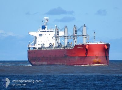
DREAM SKY
Cargo
Current Trip
| Time Travelled | 12 days |
|---|---|
| Remaining Time | --- |
| Distance Travelled | 3213.74 nm |
| Remaining Distance | 1720.84 nm |
| AVG Speed | 9.4 Knopen |
| MAX Speed | 15.5 Knopen |
| AVG Wind | 11 knots |
| MAX Wind | 34.3 knots |
| MIN Temp | 13.7°C / 56.66°F |
| MAX Temp | 29.5°C / 85.1°F |
| Diepgang | 11.8 M |
| Positie ontvangen | 7 d geleden |
Current Position
| Lengtegraad | 154.11246° |
|---|---|
| Breedtegraat | -28.90151° |
| Status | Under way using engine |
| Snelheid | 9.5 Knopen |
| Koers | 10.1° |
| Gebied | Coral Sea |
| Station | T-AIS |
| Positie ontvangen | 7 d geleden |
Info
Information
The current position of DREAM SKY is in Coral Sea with coordinates -28.90151° / 154.11246° as reported on 2024-04-08 08:00 by AIS to our vessel tracker app. The vessel's current speed is 9.5 Knopen and is heading at the port of YOKOHAMA. The estimated time of arrival as calculated by MyShipTracking vessel tracking app is 2024-04-21 21:00 LT
The vessel DREAM SKY (IMO: 9839076, MMSI: 354437000) is a Cargo It's sailing under the flag of [PA] Panama.
In this page you can find informations about the vessels current position, last detected port calls, and current voyage information. If the vessels is not in coverage by AIS you will find the latest position.
The current position of DREAM SKY is detected by our AIS receivers and we are not responsible for the reliability of the data. The last position was recorded while the vessel was in Coverage by the Ais receivers of our vessel tracking app.
The current draught of DREAM SKY as reported by AIS is 11.8 meters
Weather
| Temperature | 28.2°C / 82.76°F |
|---|---|
| Wind Speed | 9 knots |
| Direction | 43° NE |
| Pressure | 1008.4 hPa |
| Humidity | 79.6 % |
| Cloud Coverage | 89 % |
Featured Company
Most Visited Ports (Last year)
| Port | Arrivals | |
|---|---|---|
| 3 | ||
| 2 | ||
| 1 | ||
| 1 | ||
| 1 | ||
| 1 |
Events
| Tijd | Evenement | Details | Positie / Bestemming | Info |
|---|---|---|---|---|
| 2024-04-08 08:08 | Status Changed | Default Under way using engine |
-28.88029 / 154.11713
JP YOK
|
Snelheid: 9.5 kn Koers: 10.1° |
| 2024-04-08 08:00 | Buitenbereik |
-28.90151 / 154.11246
Coral Sea
JP YOK
|
Snelheid: 9.5 kn Koers: 10.1° |
|
| 2024-04-08 07:58 | Status Changed | Under way using engine Default |
-28.90762 / 154.11112
JP YOK
|
Snelheid: 9.4 kn Koers: 12° |
| 2024-04-08 07:48 | Binnenbereik |
-28.90762 / 154.11112
Coral Sea
JP YOK
|
Snelheid: 9.4 kn Koers: 11.8° |
|
| 2024-04-08 06:36 | Status Changed | Default Under way using engine |
-29.11507 / 154.08206
JP YOK
|
Snelheid: 9.7 kn Koers: 18.2° |
| 2024-04-08 06:30 | Wijzig zee gebeid | Australian part of the Coral Sea Australian part of the Tasman Sea |
-29.13216 / 154.07630
Coral Sea
JP YOK
|
Snelheid: 9.7 kn Koers: 18.2° |
| 2024-04-08 06:30 | Status Changed | Under way using engine Default |
-29.13216 / 154.07630
JP YOK
|
Snelheid: 9.6 kn Koers: 18° |
| 2024-04-08 06:30 | Buitenbereik |
-29.13216 / 154.07630
Coral Sea
JP YOK
|
Snelheid: 9.7 kn Koers: 18.2° |
|
| 2024-04-08 06:20 | Binnenbereik |
-29.13216 / 154.07630
Coral Sea
JP YOK
|
Snelheid: 9.7 kn Koers: 18.2° |
|
| 2024-04-07 09:46 | Buitenbereik |
-32.45386 / 152.95423
Tasman Sea
JP YOK
|
Snelheid: 8.2 kn Koers: 23.3° |