
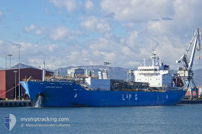
DANCING BRAVE
Tanker
Current Trip
| Trip Time | 15 days |
|---|---|
| Trip Distance | 4124.74 nm |
| AVG Speed | 11.7 Knopen |
| MAX Speed | 16.2 Knopen |
| Diepgang | 9.4 M |
| AVG Wind | 16.2 knots |
| MAX Wind | 26 knots |
| MIN Temp | 6.5°C / 43.7°F |
| MAX Temp | 33.2°C / 91.76°F |
| Positie ontvangen | 1 m geleden |
Current Position
| Lengtegraad | 4.28627° |
|---|---|
| Breedtegraat | 51.34384° |
| Status | Under way using engine |
| Snelheid | 0.1 Knopen |
| Koers | 96° |
| Gebied | North Sea |
| Station | T-AIS |
| Positie ontvangen | 1 m geleden |
Info
Information
The current position of DANCING BRAVE is in North Sea with coordinates 51.34384° / 4.28627° as reported on 2024-04-24 14:53 by AIS to our vessel tracker app. The vessel's current speed is 0.1 Knopen and is currently inside the port of ANTWERP.
The vessel DANCING BRAVE (IMO: 9798179, MMSI: 563033300) is a Tanker It's sailing under the flag of [SG] Singapore.
In this page you can find informations about the vessels current position, last detected port calls, and current voyage information. If the vessels is not in coverage by AIS you will find the latest position.
The current position of DANCING BRAVE is detected by our AIS receivers and we are not responsible for the reliability of the data. The last position was recorded while the vessel was in Coverage by the Ais receivers of our vessel tracking app.
The current draught of DANCING BRAVE as reported by AIS is 9.4 meters
Weather
| Temperature | 9.6°C / 49.28°F |
|---|---|
| Wind Speed | 14 knots |
| Direction | 327° NNW |
| Pressure | 1010.3 hPa |
| Humidity | 54 % |
| Cloud Coverage | 89 % |
Featured Company
Last Port Calls
| Port | Arrival | Departure | Time In Port |
|---|---|---|---|
| 2024-04-24 13:25 | |||
| 2024-04-07 15:43 | 2024-04-08 17:39 | 1 d | |
| 2024-03-20 11:35 | 2024-03-21 09:00 | 21 h | |
| 2024-03-13 13:08 | 2024-03-14 22:25 | 1 d | |
| 2024-03-05 11:06 | 2024-03-06 04:03 | 16 h | |
| 2024-02-29 23:13 | 2024-03-02 06:22 | 1 d | |
| 2024-02-13 11:08 | 2024-02-14 14:40 | 1 d |
Most Visited Ports (Last year)
| Port | Arrivals | |
|---|---|---|
| 9 | ||
| 4 | ||
| 3 | ||
| 3 | ||
| 2 | ||
| 2 |
Last Trips
| Origin | Departure | Destination | Arrival | Distance | |
|---|---|---|---|---|---|
| 2024-04-08 13:39 | 2024-04-24 15:25 | 4124.74 nm | |||
| 2024-03-21 10:00 | 2024-04-07 11:43 | 4968.28 nm | |||
| 2024-03-14 23:25 | 2024-03-20 12:35 | 827.46 nm | |||
| 2024-03-06 05:03 | 2024-03-13 14:08 | 654.36 nm | |||
| 2024-03-02 07:22 | 2024-03-05 12:06 | 923.65 nm | |||
| 2024-02-14 10:40 | 2024-03-01 00:13 | 4678.48 nm | |||
| 2024-01-06 22:26 | 2024-02-13 07:08 | 7592.22 nm |
Events
| Tijd | Evenement | Details | Positie / Bestemming | Info |
|---|---|---|---|---|
| 2024-04-24 14:03 | Stop beweging |
51.34389 / 4.28615
[BE] ANTWERP
|
Snelheid: 0.3 kn Koers: 96° |
|
| 2024-04-24 13:25 | Aankomsthaven |
|
51.36579 / 4.21983
[BE] ANTWERP
|
Snelheid: 9.9 kn Koers: 164.4° |
| 2024-04-24 12:46 | Start beweging | 1.37 nm, South East of WALSOORDEN |
51.37192 / 4.06718
BEANR
|
Snelheid: 13.3 kn Koers: 104.4° |
| 2024-04-24 12:45 | Stop beweging | 1.23 nm, South East of WALSOORDEN |
51.37251 / 4.06339
BEANR
|
Snelheid: Koers: 0° |
| 2024-04-24 12:44 | Start beweging | 1.02 nm, South East of WALSOORDEN |
51.37342 / 4.05781
BEANR
|
Snelheid: 12.9 kn Koers: 105.7° |
| 2024-04-24 12:43 | Stop beweging | 0.88 nm, South East of WALSOORDEN |
51.37406 / 4.05420
BEANR
|
Snelheid: Koers: 0° |
| 2024-04-24 12:41 | Start beweging | 0.51 nm, South East of WALSOORDEN |
51.37714 / 4.04577
BEANR
|
Snelheid: 13.3 kn Koers: 135.9° |
| 2024-04-24 12:41 | Stop beweging | 0.41 nm, South East of WALSOORDEN |
51.37857 / 4.04389
BEANR
|
Snelheid: Koers: 0° |
| 2024-04-24 12:38 | Start beweging | 0.49 nm, North of WALSOORDEN |
51.39009 / 4.03530
BEANR
|
Snelheid: 14.6 kn Koers: 170° |
| 2024-04-24 12:37 | Stop beweging | 0.61 nm, North of WALSOORDEN |
51.39202 / 4.03479
BEANR
|
Snelheid: Koers: 0° |