
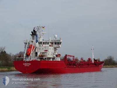
CHRISTINA
Oil/Chemical Tanker
Current Trip
NL AMS VIA NOK
| Time Travelled | 1 day |
|---|---|
| Remaining Time | --- |
| Distance Travelled | 366.81 nm |
| Remaining Distance | --- |
| AVG Speed | 13.3 Knopen |
| MAX Speed | 14.1 Knopen |
| AVG Wind | 17 knots |
| MAX Wind | 20.9 knots |
| MIN Temp | -1.3°C / 29.66°F |
| MAX Temp | 0.8°C / 33.44°F |
| Diepgang | 6.3 M |
| Positie ontvangen | 1 h, 29 m geleden |
Current Position
| Lengtegraad | 18.66613° |
|---|---|
| Breedtegraat | 58.37938° |
| Status | Under way using engine |
| Snelheid | 13.5 Knopen |
| Koers | 212° |
| Gebied | Baltic Sea |
| Station | T-AIS |
| Positie ontvangen | 1 h, 29 m geleden |
Info
Information
The current position of CHRISTINA is in Baltic Sea with coordinates 58.37938° / 18.66613° as reported on 2024-04-20 04:19 by AIS to our vessel tracker app. The vessel's current speed is 13.5 Knopen
The vessel CHRISTINA (IMO: 9118496, MMSI: 259372000) is a Oil/Chemical Tanker that was built in 1996 ( 28 Jaar oud ). It's sailing under the flag of [NO] Norway.
In this page you can find informations about the vessels current position, last detected port calls, and current voyage information. If the vessels is not in coverage by AIS you will find the latest position.
The current position of CHRISTINA is detected by our AIS receivers and we are not responsible for the reliability of the data. The last position was recorded while the vessel was in Coverage by the Ais receivers of our vessel tracking app.
The current draught of CHRISTINA as reported by AIS is 6.3 meters
Weather
| Temperature | 0.2°C / 32.36°F |
|---|---|
| Wind Speed | 17 knots |
| Direction | 345° NNW |
| Pressure | 1009.3 hPa |
| Humidity | 82 % |
| Cloud Coverage | 100 % |
Featured Company
Last Port Calls
| Port | Arrival | Departure | Time In Port |
|---|---|---|---|
| 2024-04-17 08:16 | 2024-04-18 21:40 | 1 d | |
| 2024-04-15 18:50 | 2024-04-16 12:47 | 17 h | |
| 2024-04-12 07:35 | 2024-04-13 01:42 | 18 h | |
| 2024-04-10 14:03 | 2024-04-11 05:26 | 15 h | |
| 2024-04-07 05:37 | 2024-04-07 19:09 | 13 h | |
| 2024-03-29 16:37 | 2024-03-31 22:46 | 2 d | |
| 2024-03-27 12:37 | 2024-03-28 02:13 | 13 h | |
| 2024-03-24 18:24 | 2024-03-26 07:40 | 1 d | |
| 2024-03-19 23:32 | 2024-03-20 20:10 | 20 h | |
| 2024-03-14 20:43 | 2024-03-15 07:00 | 10 h |
Most Visited Ports (Last year)
| Port | Arrivals | |
|---|---|---|
| 12 | ||
| 9 | ||
| 9 | ||
| 5 | ||
| 4 | ||
| 4 |
Last Trips
| Origin | Departure | Destination | Arrival | Distance | |
|---|---|---|---|---|---|
| 2024-04-16 14:47 | 2024-04-17 11:16 | 239.59 nm | |||
| 2024-04-13 03:42 | 2024-04-15 20:50 | 819.27 nm | |||
| 2024-04-11 07:26 | 2024-04-12 09:35 | 171.09 nm | |||
| 2024-04-07 22:09 | 2024-04-10 16:03 | 809.41 nm | |||
| 2024-04-01 00:46 | 2024-04-07 08:37 | 1249.55 nm | |||
| 2024-03-28 03:13 | 2024-03-29 17:37 | 396.85 nm | |||
| 2024-03-26 08:40 | 2024-03-27 13:37 | 304.74 nm | |||
| 2024-03-20 21:10 | 2024-03-24 19:24 | 545.74 nm | |||
| 2024-03-15 09:00 | 2024-03-20 00:32 | 1061.74 nm | |||
| 2024-03-14 15:11 | 2024-03-14 22:43 | 93.59 nm |
Events
| Tijd | Evenement | Details | Positie / Bestemming | Info |
|---|---|---|---|---|
| 2024-04-20 04:24 | Status Changed | Default Under way using engine |
58.36259 / 18.64724
NL AMS VIA NOK
|
Snelheid: 13.5 kn Koers: 212° |
| 2024-04-20 04:19 | Buitenbereik |
58.37938 / 18.66613
Baltic Sea
NL AMS VIA NOK
|
Snelheid: 13.5 kn Koers: 212° |
|
| 2024-04-20 02:03 | Status Changed | Under way using engine Default |
58.82020 / 19.15983
NL AMS VIA NOK
|
Snelheid: 13.4 kn Koers: 210° |
| 2024-04-20 01:38 | Status Changed | Default Under way using engine |
58.89900 / 19.24893
NL AMS VIA NOK
|
Snelheid: 13.6 kn Koers: 209.9° |
| 2024-04-20 01:35 | Status Changed | Under way using engine Default |
58.90923 / 19.26050
NL AMS VIA NOK
|
Snelheid: 13.6 kn Koers: 210° |
| 2024-04-20 01:20 | Binnenbereik |
58.90923 / 19.26050
Baltic Sea
NL AMS VIA NOK
|
Snelheid: 13.6 kn Koers: 209.9° |
|
| 2024-04-19 22:44 | Status Changed | Default Under way using engine |
59.46722 / 19.89641
NL AMS VIA NOK
|
Snelheid: 13.6 kn Koers: 210.4° |
| 2024-04-19 22:38 | Buitenbereik |
59.48759 / 19.91983
Baltic Sea
NL AMS VIA NOK
|
Snelheid: 13.6 kn Koers: 210.4° |
|
| 2024-04-19 22:29 | Status Changed | Under way using engine Default |
59.51769 / 19.94214
NL AMS VIA NOK
|
Snelheid: 13.8 kn Koers: 193° |
| 2024-04-19 22:24 | Status Changed | Default Under way using engine |
59.53729 / 19.95122
NL AMS VIA NOK
|
Snelheid: 13.8 kn Koers: 193° |