
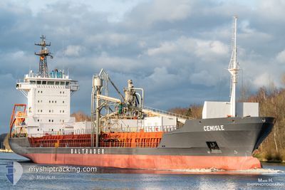
CEMISLE
Cement Carrier
Current Trip
| Time Travelled | 1 day |
|---|---|
| Remaining Time | 1 h, 32 mins |
| Distance Travelled | 371.38 nm |
| Remaining Distance | 22.16 nm |
| AVG Speed | 11.5 Knopen |
| MAX Speed | 13 Knopen |
| AVG Wind | 12.4 knots |
| MAX Wind | 27 knots |
| MIN Temp | 3.9°C / 39.02°F |
| MAX Temp | 8.4°C / 47.12°F |
| Diepgang | 4.4 M |
| Positie ontvangen | Nu |
Current Position
| Lengtegraad | 8.67883° |
|---|---|
| Breedtegraat | 53.91067° |
| Status | Under way using engine |
| Snelheid | 12.7 Knopen |
| Koers | 152° |
| Gebied | North Sea |
| Station | T-AIS |
| Positie ontvangen | Nu |
Info
Information
The current position of CEMISLE is in North Sea with coordinates 53.91067° / 8.67883° as reported on 2024-04-18 08:34 by AIS to our vessel tracker app. The vessel's current speed is 12.7 Knopen and is heading at the port of BRUNSBUETTEL. The estimated time of arrival as calculated by MyShipTracking vessel tracking app is 2024-04-18 10:07 LT
The vessel CEMISLE (IMO: 9213911, MMSI: 305399000) is a Cement Carrier that was built in 2000 ( 24 Jaar oud ). It's sailing under the flag of [AG] Antigua Barbuda.
In this page you can find informations about the vessels current position, last detected port calls, and current voyage information. If the vessels is not in coverage by AIS you will find the latest position.
The current position of CEMISLE is detected by our AIS receivers and we are not responsible for the reliability of the data. The last position was recorded while the vessel was in Coverage by the Ais receivers of our vessel tracking app.
The current draught of CEMISLE as reported by AIS is 4.4 meters
Weather
| Temperature | 7.9°C / 46.22°F |
|---|---|
| Wind Speed | 5 knots |
| Direction | 289° WNW |
| Pressure | 1016.3 hPa |
| Humidity | 73.1 % |
| Cloud Coverage | 6 % |
Featured Company
Last Port Calls
| Port | Arrival | Departure | Time In Port |
|---|---|---|---|
| 2024-04-15 13:13 | 2024-04-16 23:18 | 1 d | |
| 2024-04-12 10:20 | 2024-04-14 03:23 | 1 d | |
| 2024-04-10 10:44 | 2024-04-11 16:12 | 1 d | |
| 2024-04-10 10:10 | 2024-04-10 10:17 | 7 m | |
| 2024-04-06 23:15 | 2024-04-08 06:14 | 1 d | |
| 2024-04-06 23:02 | |||
| 2024-04-06 19:47 | |||
| 2024-04-04 02:31 | 2024-04-05 06:37 | 1 d | |
| 2024-04-02 06:16 | 2024-04-02 07:54 | 1 h | |
| 2024-03-31 17:00 | 2024-04-02 06:16 | 1 d |
Last Trips
| Origin | Departure | Destination | Arrival | Distance | |
|---|---|---|---|---|---|
| 2024-04-14 05:23 | 2024-04-15 14:13 | 330.47 nm | |||
| 2024-04-11 17:12 | 2024-04-12 12:20 | 184.74 nm | |||
| 2024-04-10 11:17 | 2024-04-10 11:44 | 0.83 nm | |||
| 2024-04-08 08:14 | 2024-04-10 11:10 | 393.83 nm | |||
| 2024-04-05 07:37 | 2024-04-07 01:15 | 387.32 nm | |||
| 2024-04-05 07:37 | 2024-04-07 01:02 | 387.00 nm | |||
| 2024-04-05 07:37 | 2024-04-06 21:47 | 386.92 nm | |||
| 2024-04-02 09:54 | 2024-04-04 03:31 | 396.36 nm | |||
| 2024-04-02 08:16 | 2024-04-02 08:16 | 0.03 nm | |||
| 2024-03-30 06:43 | 2024-03-31 19:00 | 386.53 nm |
Events
| Tijd | Evenement | Details | Positie / Bestemming | Info |
|---|---|---|---|---|
| 2024-04-18 06:09 | Binnenbereik |
54.03983 / 7.92833
North Sea
BRUNSBUTTEL
|
Snelheid: 10.2 kn Koers: 123.8° |
|
| 2024-04-18 04:47 | Buitenbereik |
54.15800 / 7.59333
North Sea
BRUNSBUTTEL
|
Snelheid: 9.2 kn Koers: 120.4° |
|
| 2024-04-18 03:11 | Status Changed | Under way using engine Default |
54.30417 / 7.19400
BRUNSBUTTEL
|
Snelheid: 10.7 kn Koers: 122° |
| 2024-04-18 03:00 | Status Changed | Default Under way using engine |
54.32283 / 7.14467
BRUNSBUTTEL
|
Snelheid: 10.7 kn Koers: 122.3° |
| 2024-04-18 02:12 | Status Changed | Under way using engine Default |
54.40133 / 6.93967
BRUNSBUTTEL
|
Snelheid: 11 kn Koers: 123° |
| 2024-04-18 02:07 | Status Changed | Default Under way using engine |
54.40833 / 6.92167
BRUNSBUTTEL
|
Snelheid: 10.4 kn Koers: 122.5° |
| 2024-04-18 01:54 | Status Changed | Under way using engine Default |
54.42950 / 6.86600
BRUNSBUTTEL
|
Snelheid: 10.5 kn Koers: 124° |
| 2024-04-18 01:39 | Status Changed | Default Under way using engine |
54.45467 / 6.79900
BRUNSBUTTEL
|
Snelheid: 11 kn Koers: 109.7° |
| 2024-04-18 01:25 | Draught Changed | 4.4 4.3 |
54.47483 / 6.73717
BRUNSBUTTEL
|
Snelheid: 11 kn Koers: 113° |
| 2024-04-18 01:20 | Wijzig zee gebeid | German part of the North Sea United Kingdom part of the North Sea |
54.48050 / 6.71200
North Sea
BRUNSBUTTEL
|
Snelheid: 11 kn Koers: 113.2° |