
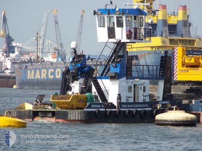
CATHARINA 5
Cargo
Current Trip
| Time Travelled | 12 h, 45 mins |
|---|---|
| Remaining Time | --- |
| Distance Travelled | 40.96 nm |
| Remaining Distance | --- |
| AVG Speed | 5.3 Knopen |
| MAX Speed | 7.7 Knopen |
| AVG Wind | 18 knots |
| MAX Wind | 24 knots |
| MIN Temp | 5.2°C / 41.36°F |
| MAX Temp | 9.8°C / 49.64°F |
| Diepgang | 3 M |
| Positie ontvangen | 3 m geleden |
Current Position
| Lengtegraad | 5.43497° |
|---|---|
| Breedtegraat | 52.54172° |
| Status | Moored |
| Snelheid | |
| Koers | 334° |
| Gebied | North Sea |
| Station | T-AIS |
| Positie ontvangen | 3 m geleden |
Info
Information
The current position of CATHARINA 5 is in North Sea with coordinates 52.54172° / 5.43497° as reported on 2024-04-24 18:41 by AIS to our vessel tracker app. The vessel's current speed is 0 Knopen and is heading at the port of NORDDEICH.
The vessel CATHARINA 5 (MMSI: 244650935) is a Cargo It's sailing under the flag of [NL] Netherlands.
In this page you can find informations about the vessels current position, last detected port calls, and current voyage information. If the vessels is not in coverage by AIS you will find the latest position.
The current position of CATHARINA 5 is detected by our AIS receivers and we are not responsible for the reliability of the data. The last position was recorded while the vessel was in Coverage by the Ais receivers of our vessel tracking app.
The current draught of CATHARINA 5 as reported by AIS is 3 meters
Weather
| Temperature | 7.8°C / 46.04°F |
|---|---|
| Wind Speed | 17 knots |
| Direction | 350° N |
| Pressure | 1007.6 hPa |
| Humidity | 64.2 % |
| Cloud Coverage | 68 % |
Featured Company
Last Port Calls
| Port | Arrival | Departure | Time In Port |
|---|---|---|---|
| 2024-04-23 13:01 | 2024-04-24 06:00 | 16 h | |
| 2024-04-23 11:47 | 2024-04-23 12:46 | 59 m | |
| 2024-04-22 06:32 | 2024-04-23 04:29 | 21 h | |
| 2024-04-22 05:48 | 2024-04-22 06:21 | 33 m | |
| 2024-04-18 16:46 | 2024-04-22 05:32 | 3 d | |
| 2024-04-15 06:14 | 2024-04-15 11:07 | 4 h | |
| 2024-04-12 09:53 | 2024-04-15 05:39 | 2 d | |
| 2024-04-12 09:16 | 2024-04-12 09:41 | 25 m | |
| 2024-04-11 17:03 | 2024-04-12 06:12 | 13 h | |
| 2024-04-11 13:16 | 2024-04-11 14:27 | 1 h |
Most Visited Ports (Last year)
| Port | Arrivals | |
|---|---|---|
| 16 | ||
| 14 | ||
| 11 | ||
| 5 | ||
| 5 | ||
| 4 |
Last Trips
| Origin | Departure | Destination | Arrival | Distance | |
|---|---|---|---|---|---|
| 2024-04-23 14:46 | 2024-04-23 15:01 | 0.90 nm | |||
| 2024-04-23 06:29 | 2024-04-23 13:47 | 28.74 nm | |||
| 2024-04-22 08:21 | 2024-04-22 08:32 | 0.47 nm | |||
| 2024-04-22 07:32 | 2024-04-22 07:48 | 1.93 nm | |||
| 2024-04-15 13:07 | 2024-04-18 18:46 | 84.63 nm | |||
| 2024-04-15 07:39 | 2024-04-15 08:14 | 4.71 nm | |||
| 2024-04-12 11:41 | 2024-04-12 11:53 | 1.31 nm | |||
| 2024-04-12 08:12 | 2024-04-12 11:16 | 17.60 nm | |||
| 2024-04-11 16:27 | 2024-04-11 19:03 | 21.36 nm | |||
| 2024-04-11 15:14 | 2024-04-11 15:16 | 0.07 nm |
Events
| Tijd | Evenement | Details | Positie / Bestemming | Info |
|---|---|---|---|---|
| 2024-04-24 18:14 | Status Changed | Moored Under way using engine |
52.54180 / 5.43497
DENOEVER
|
Snelheid: Koers: 340° |
| 2024-04-24 17:40 | Stop beweging | 0.95 nm, North of LELYSTAD |
52.54192 / 5.43487
DENOEVER
|
Snelheid: 0.2 kn Koers: 354° |
| 2024-04-24 17:34 | Start beweging | 0.38 nm, North West of LELYSTAD |
52.53201 / 5.43464
DENOEVER
|
Snelheid: 7.5 kn Koers: 8.5° |
| 2024-04-24 17:29 | Stop beweging | 0.29 nm, North West of LELYSTAD |
52.53019 / 5.43405
DENOEVER
|
Snelheid: 0.3 kn Koers: 355° |
| 2024-04-24 17:23 | Start beweging | 0.81 nm, North of LELYSTAD |
52.53964 / 5.43614
DENOEVER
|
Snelheid: 7.1 kn Koers: 152.6° |
| 2024-04-24 17:11 | Stop beweging | 0.93 nm, North of LELYSTAD |
52.54147 / 5.43456
DENOEVER
|
Snelheid: 0.3 kn Koers: 15° |
| 2024-04-24 16:54 | Start beweging | 0.27 nm, North West of LELYSTAD |
52.53023 / 5.43505
DENOEVER
|
Snelheid: 3.1 kn Koers: 6° |
| 2024-04-24 16:33 | Stop beweging | 0.19 nm, South West of LELYSTAD |
52.52421 / 5.43482
DENOEVER
|
Snelheid: 0.2 kn Koers: 353° |
| 2024-04-24 16:27 | Start beweging | 0.46 nm, South of LELYSTAD |
52.51914 / 5.43418
DENOEVER
|
Snelheid: 3.3 kn Koers: 353° |
| 2024-04-24 16:27 | Status Changed | Under way using engine Moored |
52.51857 / 5.43430
DENOEVER
|
Snelheid: 1.9 kn Koers: 346° |