
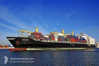
CALANDRA
Container Ship
Current Trip
BR PGU
| Time Travelled | 19 h, 56 mins |
|---|---|
| Remaining Time | --- |
| Distance Travelled | 3.55 nm |
| Remaining Distance | --- |
| AVG Speed | 3.8 Knopen |
| MAX Speed | 4.3 Knopen |
| AVG Wind | 2.9 knots |
| MAX Wind | 5.1 knots |
| MIN Temp | 14.1°C / 57.38°F |
| MAX Temp | 24.8°C / 76.64°F |
| Diepgang | 8.8 M |
| Positie ontvangen | 1 d geleden |
Current Position
| Lengtegraad | -48.34546° |
|---|---|
| Breedtegraat | -25.55393° |
| Status | Under way using engine |
| Snelheid | 13.1 Knopen |
| Koers | 316° |
| Gebied | South Atlantic Ocean |
| Station | T-AIS |
| Positie ontvangen | 1 d geleden |
Info
Information
The current position of CALANDRA is in South Atlantic Ocean with coordinates -25.55393° / -48.34546° as reported on 2024-04-19 03:10 by AIS to our vessel tracker app. The vessel's current speed is 13.1 Knopen
The vessel CALANDRA (IMO: 9445887, MMSI: 305538000) is a Container Ship that was built in 2010 ( 14 Jaar oud ). It's sailing under the flag of [AG] Antigua Barbuda.
In this page you can find informations about the vessels current position, last detected port calls, and current voyage information. If the vessels is not in coverage by AIS you will find the latest position.
The current position of CALANDRA is detected by our AIS receivers and we are not responsible for the reliability of the data. The last position was recorded while the vessel was in Coverage by the Ais receivers of our vessel tracking app.
The current draught of CALANDRA as reported by AIS is 8.8 meters
Weather
| Temperature | 24°C / 75.2°F |
|---|---|
| Wind Speed | 3 knots |
| Direction | 43° NE |
| Pressure | 1020.7 hPa |
| Humidity | 55 % |
| Cloud Coverage | --- |
Featured Company
Last Port Calls
| Port | Arrival | Departure | Time In Port |
|---|---|---|---|
| 2024-04-19 04:51 | 2024-04-19 18:59 | 14 h | |
| 2024-04-17 10:41 | 2024-04-18 01:46 | 15 h | |
| 2024-04-01 14:58 | 2024-04-02 06:08 | 15 h | |
| 2024-03-27 08:19 | 2024-03-28 18:37 | 1 d | |
| 2024-03-21 14:59 | 2024-03-22 18:51 | 1 d | |
| 2024-03-16 01:40 | 2024-03-16 13:37 | 11 h | |
| 2024-03-13 20:22 | 2024-03-14 05:40 | 9 h | |
| 2024-03-09 19:01 | 2024-03-10 13:37 | 18 h | |
| 2024-03-07 22:29 | 2024-03-08 07:12 | 8 h | |
| 2024-02-24 13:14 | 2024-02-24 13:20 | 6 m |
Last Trips
| Origin | Departure | Destination | Arrival | Distance | |
|---|---|---|---|---|---|
| 2024-04-17 22:46 | 2024-04-19 01:51 | 76.42 nm | |||
| 2024-04-02 01:08 | 2024-04-17 07:41 | 4496.68 nm | |||
| 2024-03-28 13:37 | 2024-04-01 09:58 | 633.07 nm | |||
| 2024-03-22 13:51 | 2024-03-27 03:19 | 1131.49 nm | |||
| 2024-03-16 07:37 | 2024-03-21 09:59 | 818.07 nm | |||
| 2024-03-13 23:40 | 2024-03-15 19:40 | 249.30 nm | |||
| 2024-03-10 08:37 | 2024-03-13 14:22 | 1217.86 nm | |||
| 2024-03-08 02:12 | 2024-03-09 14:01 | 475.02 nm | |||
| 2024-02-24 10:20 | 2024-03-07 17:29 | 4111.71 nm | |||
| 2024-02-23 19:02 | 2024-02-24 10:14 | 215.64 nm |
Events
| Tijd | Evenement | Details | Positie / Bestemming | Info |
|---|---|---|---|---|
| 2024-04-19 20:04 | Stop beweging | 0.57 nm, North West of PARANAGUA |
-25.49425 / -48.52557
BR PGU
|
Snelheid: 0.1 kn Koers: 273° |
| 2024-04-19 19:26 | Start beweging | 0.34 nm, North East of PARANAGUA |
-25.49816 / -48.51198
BR PGU
|
Snelheid: 3.9 kn Koers: 285° |
| 2024-04-19 18:59 | Vertrekhaven |
|
-25.49689 / -48.51453
BR PGU
|
Snelheid: 0.4 kn Koers: 76° |
| 2024-04-19 04:51 | Stop beweging |
-25.50082 / -48.50142
[BR] PARANAGUA
|
Snelheid: Koers: 81° |
|
| 2024-04-19 04:51 | Aankomsthaven |
|
-25.50082 / -48.50142
[BR] PARANAGUA
|
Snelheid: 2 kn Koers: 104° |
| 2024-04-19 03:16 | Status Changed | Default Under way using engine |
-25.53835 / -48.36197
BR PGU
|
Snelheid: 13.1 kn Koers: 316° |
| 2024-04-19 03:10 | Buitenbereik |
-25.55393 / -48.34546
South Atlantic Ocean
BR PGU
|
Snelheid: 13.1 kn Koers: 316° |
|
| 2024-04-19 02:40 | ETA Changed | 2024/04/19 21:00 2024/04/19 01:00 |
-25.62420 / -48.26616
BR PGU
|
Snelheid: 9.5 kn Koers: 305.8° |
| 2024-04-19 02:12 | Status Changed | Under way using engine Default |
-25.67579 / -48.21263
BR PGU
|
Snelheid: 4.1 kn Koers: 159° |
| 2024-04-19 01:58 | Binnenbereik |
-25.67579 / -48.21263
South Atlantic Ocean
BR PGU
|
Snelheid: 13.4 kn Koers: 314.5° |