
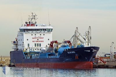
BLUE BIRD
Oil/Chemical Tanker
Current Trip
| Time Travelled | 8 days |
|---|---|
| Remaining Time | --- |
| Distance Travelled | 1628.24 nm |
| Remaining Distance | --- |
| AVG Speed | 9.9 Knopen |
| MAX Speed | 13 Knopen |
| AVG Wind | 12.4 knots |
| MAX Wind | 32.9 knots |
| MIN Temp | 10.5°C / 50.9°F |
| MAX Temp | 37.9°C / 100.22°F |
| Diepgang | 6 M |
| Positie ontvangen | 1 d geleden |
Current Position
| Lengtegraad | 32.55124° |
|---|---|
| Breedtegraat | 29.86993° |
| Status | Under way using engine |
| Snelheid | 8.7 Knopen |
| Koers | 170.3° |
| Gebied | Gulf of Suez |
| Station | T-AIS |
| Positie ontvangen | 1 d geleden |
Info
Information
The current position of BLUE BIRD is in Gulf of Suez with coordinates 29.86993° / 32.55124° as reported on 2024-04-23 13:45 by AIS to our vessel tracker app. The vessel's current speed is 8.7 Knopen
The vessel BLUE BIRD (IMO: 9527764, MMSI: 215691000) is a Oil/Chemical Tanker that was built in 2011 ( 13 Jaar oud ). It's sailing under the flag of [MT] Malta.
In this page you can find informations about the vessels current position, last detected port calls, and current voyage information. If the vessels is not in coverage by AIS you will find the latest position.
The current position of BLUE BIRD is detected by our AIS receivers and we are not responsible for the reliability of the data. The last position was recorded while the vessel was in Coverage by the Ais receivers of our vessel tracking app.
The current draught of BLUE BIRD as reported by AIS is 6 meters
Weather
| Temperature | 26.2°C / 79.16°F |
|---|---|
| Wind Speed | 10 knots |
| Direction | 26° NNE |
| Pressure | 1010.4 hPa |
| Humidity | 54.1 % |
| Cloud Coverage | --- |
Featured Company
Last Port Calls
| Port | Arrival | Departure | Time In Port |
|---|---|---|---|
| 2024-04-22 22:17 | 2024-04-23 13:06 | 14 h | |
| 2024-04-15 23:38 | 2024-04-16 16:17 | 16 h | |
| 2024-04-05 21:52 | 2024-04-07 10:01 | 1 d | |
| 2024-03-31 07:01 | 2024-04-01 10:10 | 1 d | |
| 2024-03-26 20:27 | |||
| 2024-02-21 10:48 | 2024-02-23 02:19 | 1 d | |
| 2024-02-03 13:39 | 2024-02-05 07:34 | 1 d |
Last Trips
| Origin | Departure | Destination | Arrival | Distance | |
|---|---|---|---|---|---|
| 2024-04-16 18:17 | 2024-04-23 00:17 | 1350.27 nm | |||
| 2024-04-07 13:01 | 2024-04-16 01:38 | 1223.60 nm | |||
| 2024-04-01 13:10 | 2024-04-06 00:52 | 860.02 nm | |||
| 2024-03-26 22:27 | 2024-03-31 10:01 | 585.36 nm | |||
| 2024-02-05 10:34 | 2024-02-21 12:48 | 367.14 nm | |||
| 2024-01-25 16:26 | 2024-02-03 16:39 | 2126.65 nm |
Events
| Tijd | Evenement | Details | Positie / Bestemming | Info |
|---|---|---|---|---|
| 2024-04-23 13:52 | Status Changed | Default Under way using engine |
29.85039 / 32.55301
ITRAN>JOAQJ
|
Snelheid: 8.7 kn Koers: 170.3° |
| 2024-04-23 13:45 | Buitenbereik |
29.86993 / 32.55124
Gulf of Suez
ITRAN>JOAQJ
|
Snelheid: 8.7 kn Koers: 170.3° |
|
| 2024-04-23 13:07 | Wijzig zee gebeid | Egyptian part of the Gulf of Suez Egyptian part of the Mediterranean Sea - Eastern Basin |
29.94375 / 32.57570
Gulf of Suez
ITRAN>JOAQJ
|
Snelheid: 7.2 kn Koers: 220.2° |
| 2024-04-23 13:06 | Vertrekhaven |
|
29.94483 / 32.57670
ITRAN>JOAQJ
|
Snelheid: 7.2 kn Koers: 213° |
| 2024-04-23 10:55 | Status Changed | Under way using engine Default |
30.18526 / 32.56847
[EG] SUEZ CANAL
|
Snelheid: 7.5 kn Koers: 160° |
| 2024-04-23 10:47 | Status Changed | Default Under way using engine |
30.20204 / 32.56516
[EG] SUEZ CANAL
|
Snelheid: 7.7 kn Koers: 154° |
| 2024-04-23 10:44 | Status Changed | Under way using engine Default |
30.20747 / 32.56209
[EG] SUEZ CANAL
|
Snelheid: 8.3 kn Koers: 153° |
| 2024-04-23 10:27 | Status Changed | Default Under way using engine |
30.24339 / 32.53872
[EG] SUEZ CANAL
|
Snelheid: 8.9 kn Koers: 148° |
| 2024-04-23 10:24 | Status Changed | Under way using engine Default |
30.24885 / 32.53358
[EG] SUEZ CANAL
|
Snelheid: 9.3 kn Koers: 110° |
| 2024-04-23 10:24 | Binnenbereik |
30.24702 / 32.53550
Mediterranean Sea - Eastern Basin
[EG] SUEZ CANAL
|
Snelheid: 9 kn Koers: 138° |