
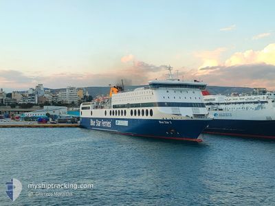
BLUE STAR 2
Passenger
Current Trip
| Trip Time | 3 h, 2 mins |
|---|---|
| Trip Distance | 60.85 nm |
| AVG Speed | 19.5 Knopen |
| MAX Speed | 22.7 Knopen |
| Diepgang | 6 M |
| AVG Wind | 13.8 knots |
| MAX Wind | 23 knots |
| MIN Temp | 15.6°C / 60.08°F |
| MAX Temp | 17.8°C / 64.04°F |
| Positie ontvangen | 1 d geleden |
Current Position
| Lengtegraad | --- |
|---|---|
| Breedtegraat | --- |
| Status | Under way using engine |
| Snelheid | 24.4 Knopen |
| Koers | 137° |
| Gebied | Aegean Sea |
| Station | T-AIS |
| Positie ontvangen | 1 d geleden |
Info
Information
The current position of BLUE STAR 2 is in Aegean Sea with coordinates 37.07684° / 26.98837° as reported on 2025-12-06 02:52 by AIS to our vessel tracker app. The vessel's current speed is 24.4 Knopen and is currently inside the port of RHODES.
The vessel BLUE STAR 2 (MMSI: 239737000) is a Passenger It's sailing under the flag of [GR] Greece.
In this page you can find informations about the vessels current position, last detected port calls, and current voyage information. If the vessels is not in coverage by AIS you will find the latest position.
The current position of BLUE STAR 2 is detected by our AIS receivers and we are not responsible for the reliability of the data. The last position was recorded while the vessel was in Coverage by the Ais receivers of our vessel tracking app.
The current draught of BLUE STAR 2 as reported by AIS is 6 meters
Weather
| Temperature | 16.5°C / 61.7°F |
|---|---|
| Wind Speed | 3 knots |
| Direction | 288° WNW |
| Pressure | 1007.6 hPa |
| Humidity | 61.4 % |
| Cloud Coverage | 100 % |
Featured Company
Last Port Calls
| Port | Arrival | Departure | Time In Port |
|---|---|---|---|
| 2025-12-06 10:18 | |||
| 2025-12-06 06:33 | 2025-12-06 07:16 | 42 m | |
| 2025-12-06 03:52 | 2025-12-06 04:28 | 35 m | |
| 2025-12-06 02:36 | 2025-12-06 02:53 | 16 m | |
| 2025-12-05 22:06 | 2025-12-05 22:27 | 20 m | |
| 2025-12-05 06:12 | 2025-12-05 18:16 | 12 h | |
| 2025-12-04 22:17 | 2025-12-04 22:44 | 26 m | |
| 2025-12-04 20:51 | 2025-12-04 21:18 | 27 m | |
| 2025-12-04 17:35 | 2025-12-04 18:46 | 1 h | |
| 2025-12-04 10:06 | 2025-12-04 15:06 | 5 h |
Last Trips
| Origin | Departure | Destination | Arrival | Distance | |
|---|---|---|---|---|---|
| 2025-12-06 07:16 | 2025-12-06 10:18 | 60.85 nm | |||
| 2025-12-06 04:28 | 2025-12-06 06:33 | 35.89 nm | |||
| 2025-12-06 02:53 | 2025-12-06 03:52 | 19.37 nm | |||
| 2025-12-05 22:27 | 2025-12-06 02:36 | 84.74 nm | |||
| 2025-12-05 18:16 | 2025-12-05 22:06 | 84.17 nm | |||
| 2025-12-04 22:44 | 2025-12-05 06:12 | 158.23 nm | |||
| 2025-12-04 21:18 | 2025-12-04 22:17 | 20.14 nm | |||
| 2025-12-04 18:46 | 2025-12-04 20:51 | 29.02 nm | |||
| 2025-12-04 15:06 | 2025-12-04 17:35 | 61.85 nm | |||
| 2025-12-04 07:11 | 2025-12-04 10:06 | 55.25 nm |
Events
| Tijd | Evenement | Details | Positie / Bestemming | Info |
|---|---|---|---|---|
| 2025-12-06 08:23 | Stop beweging |
36.44603 / 28.23820
[GR] RHODES
|
Snelheid: 0.1 kn Koers: 356° |
|
| 2025-12-06 08:18 | Aankomsthaven |
|
36.44682 / 28.23677
[GR] RHODES
|
Snelheid: 11.9 kn Koers: 158° |
| 2025-12-06 05:20 | Start beweging | 0.94 nm, East of KOS |
36.90148 / 27.31413
PI SI PA LE KA KO RH
|
Snelheid: 14.5 kn Koers: 92° |
| 2025-12-06 05:16 | Vertrekhaven |
|
36.90148 / 27.31413
PI SI PA LE KA KO RH
|
Snelheid: Koers: 38° |
| 2025-12-06 04:50 | Stop beweging |
36.89947 / 27.29152
[GR] KOS
|
Snelheid: Koers: 38° |
|
| 2025-12-06 04:33 | Aankomsthaven |
|
36.89942 / 27.29245
[GR] KOS
|
Snelheid: 25.1 kn Koers: 71° |
| 2025-12-06 03:02 | Status Changed | Default Under way using engine |
37.02377 / 27.05147
PI SI PA LE KA KO RH
|
Snelheid: 24.4 kn Koers: 137° |
| 2025-12-06 02:52 | Buitenbereik |
37.07684 / 26.98837
Aegean Sea
|
Snelheid: 24.4 kn Koers: 137° |
|
| 2025-12-06 02:28 | Vertrekhaven |
|
37.16167 / 26.85160
PI SI PA LE KA KO RH
|
Snelheid: 5.7 kn Koers: 28° |
| 2025-12-06 02:27 | Start beweging |
37.16094 / 26.85110
[GR] AGIA MARINA
|
Snelheid: 5.1 kn Koers: 23° |