
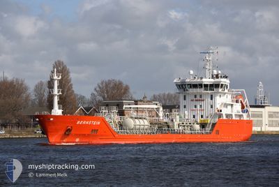
BERNSTEIN
Oil/Chemical Tanker
Current Trip
| Time Travelled | 2 days |
|---|---|
| Remaining Time | --- |
| Distance Travelled | 268.95 nm |
| Remaining Distance | --- |
| AVG Speed | 10.7 Knopen |
| MAX Speed | 13.5 Knopen |
| AVG Wind | 17.1 knots |
| MAX Wind | 21 knots |
| MIN Temp | 6.5°C / 43.7°F |
| MAX Temp | 11.8°C / 53.24°F |
| Diepgang | 4.9 M |
| Positie ontvangen | 2 m geleden |
Current Position
| Lengtegraad | -0.04709° |
|---|---|
| Breedtegraat | 49.49200° |
| Status | At anchor |
| Snelheid | 0.1 Knopen |
| Koers | 319° |
| Gebied | English Channel |
| Station | T-AIS |
| Positie ontvangen | 2 m geleden |
Info
Information
The current position of BERNSTEIN is in English Channel with coordinates 49.49200° / -0.04709° as reported on 2024-04-19 19:32 by AIS to our vessel tracker app. The vessel's current speed is 0.1 Knopen
The vessel BERNSTEIN (IMO: 9535541, MMSI: 209341000) is a Oil/Chemical Tanker that was built in 2010 ( 14 Jaar oud ). It's sailing under the flag of [CY] Cyprus.
In this page you can find informations about the vessels current position, last detected port calls, and current voyage information. If the vessels is not in coverage by AIS you will find the latest position.
The current position of BERNSTEIN is detected by our AIS receivers and we are not responsible for the reliability of the data. The last position was recorded while the vessel was in Coverage by the Ais receivers of our vessel tracking app.
The current draught of BERNSTEIN as reported by AIS is 4.9 meters
Weather
| Temperature | 10.2°C / 50.36°F |
|---|---|
| Wind Speed | 15 knots |
| Direction | 58° ENE |
| Pressure | 1020 hPa |
| Humidity | 83.7 % |
| Cloud Coverage | 8 % |
Featured Company
Last Port Calls
| Port | Arrival | Departure | Time In Port |
|---|---|---|---|
| 2024-04-15 17:23 | 2024-04-16 22:28 | 1 d | |
| 2024-04-14 09:11 | 2024-04-14 10:37 | 1 h | |
| 2024-04-13 02:32 | 2024-04-13 12:48 | 10 h | |
| 2024-04-08 23:45 | 2024-04-10 15:11 | 1 d | |
| 2024-04-06 09:56 | 2024-04-06 10:44 | 48 m | |
| 2024-04-05 15:02 | 2024-04-05 17:18 | 2 h | |
| 2024-04-02 12:30 | 2024-04-03 21:34 | 1 d | |
| 2024-04-01 00:35 | 2024-04-01 01:26 | 50 m | |
| 2024-03-29 23:11 | 2024-03-31 12:39 | 1 d | |
| 2024-03-27 00:06 | 2024-03-28 02:03 | 1 d |
Most Visited Ports (Last year)
| Port | Arrivals | |
|---|---|---|
| 61 | ||
| 19 | ||
| 17 | ||
| 4 | ||
| 3 | ||
| 2 |
Last Trips
| Origin | Departure | Destination | Arrival | Distance | |
|---|---|---|---|---|---|
| 2024-04-14 12:37 | 2024-04-15 19:23 | 276.40 nm | |||
| 2024-04-13 14:48 | 2024-04-14 11:11 | 4.56 nm | |||
| 2024-04-10 17:11 | 2024-04-13 04:32 | 274.78 nm | |||
| 2024-04-06 12:44 | 2024-04-09 01:45 | 268.68 nm | |||
| 2024-04-05 19:18 | 2024-04-06 11:56 | 3.82 nm | |||
| 2024-04-03 23:34 | 2024-04-05 17:02 | 272.66 nm | |||
| 2024-04-01 03:26 | 2024-04-02 14:30 | 278.95 nm | |||
| 2024-03-31 14:39 | 2024-04-01 02:35 | 4.15 nm | |||
| 2024-03-28 03:03 | 2024-03-30 00:11 | 272.40 nm | |||
| 2024-03-23 04:10 | 2024-03-27 01:06 | 286.18 nm |
Events
| Tijd | Evenement | Details | Positie / Bestemming | Info |
|---|---|---|---|---|
| 2024-04-17 23:20 | Status Changed | At anchor Under way using engine |
49.49087 / -.04881
FRGLO
|
Snelheid: 0.2 kn Koers: 334° |
| 2024-04-17 23:19 | Status Changed | Under way using engine At anchor |
49.49096 / -.04833
FRGLO
|
Snelheid: 0.1 kn Koers: 335° |
| 2024-04-17 23:17 | Status Changed | At anchor Under way using engine |
49.49094 / -.04845
FRGLO
|
Snelheid: 0.3 kn Koers: 336° |
| 2024-04-17 23:16 | Status Changed | Under way using engine At anchor |
49.49096 / -.04835
FRGLO
|
Snelheid: 0.2 kn Koers: 347° |
| 2024-04-17 23:11 | Status Changed | At anchor Under way using engine |
49.49092 / -.04866
FRGLO
|
Snelheid: 0.3 kn Koers: 340° |
| 2024-04-17 23:08 | Stop beweging | 6.72 nm, West of LE HAVRE |
49.49096 / -.04835
FRGLO
|
Snelheid: 0.3 kn Koers: 336° |
| 2024-04-17 18:41 | Wijzig zee gebeid | French part of the English Channel United Kingdom part of the English Channel |
50.22376 / -.16292
English Channel
|
Snelheid: 10.7 kn Koers: 187.1° |
| 2024-04-17 14:39 | Status Changed | Under way using engine Default |
50.59573 / .63502
FRGLO
|
Snelheid: 11 kn Koers: 235° |
| 2024-04-17 14:36 | Status Changed | Default Under way using engine |
50.60077 / .64741
FRGLO
|
Snelheid: 11 kn Koers: 238.8° |
| 2024-04-17 14:33 | Status Changed | Under way using engine Default |
50.60599 / .66011
FRGLO
|
Snelheid: 11.2 kn Koers: 239° |