
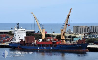
BBC GREENLAND
General Cargo
Current Trip
| Time Travelled | 2 days |
|---|---|
| Remaining Time | --- |
| Distance Travelled | 468.60 nm |
| Remaining Distance | --- |
| AVG Speed | 12.7 Knopen |
| MAX Speed | 15.3 Knopen |
| AVG Wind | 18.7 knots |
| MAX Wind | 28 knots |
| MIN Temp | 14.7°C / 58.46°F |
| MAX Temp | 21.4°C / 70.52°F |
| Diepgang | 6.9 M |
| Positie ontvangen | 16 h, 45 m geleden |
Current Position
| Lengtegraad | -52.05991° |
|---|---|
| Breedtegraat | -32.31292° |
| Status | At anchor |
| Snelheid | 0.2 Knopen |
| Koers | 240° |
| Gebied | South Atlantic Ocean |
| Station | T-AIS |
| Positie ontvangen | 16 h, 45 m geleden |
Info
Information
The current position of BBC GREENLAND is in South Atlantic Ocean with coordinates -32.31292° / -52.05991° as reported on 2024-04-18 08:22 by AIS to our vessel tracker app. The vessel's current speed is 0.2 Knopen and is heading at the port of RIO GRANDE. The estimated time of arrival as calculated by MyShipTracking vessel tracking app is 2024-04-17 23:00 LT
The vessel BBC GREENLAND (IMO: 9427079, MMSI: 305048000) is a General Cargo that was built in 2007 ( 17 Jaar oud ). It's sailing under the flag of [AG] Antigua Barbuda.
In this page you can find informations about the vessels current position, last detected port calls, and current voyage information. If the vessels is not in coverage by AIS you will find the latest position.
The current position of BBC GREENLAND is detected by our AIS receivers and we are not responsible for the reliability of the data. The last position was recorded while the vessel was in Coverage by the Ais receivers of our vessel tracking app.
The current draught of BBC GREENLAND as reported by AIS is 6.9 meters
Weather
| Temperature | 20°C / 68°F |
|---|---|
| Wind Speed | 16 knots |
| Direction | 242° WSW |
| Pressure | 1016.7 hPa |
| Humidity | 59.6 % |
| Cloud Coverage | --- |
Featured Company
Last Port Calls
| Port | Arrival | Departure | Time In Port |
|---|---|---|---|
| 2024-04-09 12:39 | 2024-04-16 08:47 | 6 d | |
| 2024-03-30 22:20 | 2024-04-05 01:15 | 5 d | |
| 2024-03-15 06:14 | 2024-03-15 07:04 | 49 m | |
| 2024-03-08 00:14 | 2024-03-08 01:03 | 48 m | |
| 2024-03-01 17:09 | 2024-03-03 12:39 | 1 d | |
| 2024-02-13 14:05 | 2024-02-15 13:37 | 1 d | |
| 2024-02-05 09:10 | 2024-02-10 07:18 | 4 d |
Last Trips
| Origin | Departure | Destination | Arrival | Distance | |
|---|---|---|---|---|---|
| 2024-04-04 22:15 | 2024-04-09 09:39 | 1199.77 nm | |||
| 2024-03-15 07:04 | 2024-03-30 19:20 | 5414.15 nm | |||
| 2024-03-08 01:03 | 2024-03-15 06:14 | 12.80 nm | |||
| 2024-03-03 13:39 | 2024-03-08 00:14 | 279.94 nm | |||
| 2024-02-15 14:37 | 2024-03-01 18:09 | 3123.26 nm | |||
| 2024-02-10 08:18 | 2024-02-13 15:05 | 89.71 nm | |||
| 2024-01-31 21:30 | 2024-02-05 10:10 | 1171.87 nm |
Events
| Tijd | Evenement | Details | Positie / Bestemming | Info |
|---|---|---|---|---|
| 2024-04-18 08:41 | Status Changed | Default At anchor |
-32.31167 / -52.05833
RIO GRANDE
|
Snelheid: 0.2 kn Koers: 240° |
| 2024-04-18 08:22 | Wijzig zee gebeid | Brazilian part of the South Atlantic Ocean Uruguayan part of the South Atlantic Ocean |
-32.31292 / -52.05991
South Atlantic Ocean
|
Snelheid: 0.2 kn Koers: 246.1° |
| 2024-04-18 08:22 | Status Changed | At anchor Default |
-32.31292 / -52.05991
RIO GRANDE
|
Snelheid: Koers: -1° |
| 2024-04-18 08:22 | Buitenbereik |
-32.31292 / -52.05991
South Atlantic Ocean
|
Snelheid: 0.2 kn Koers: 246.1° |
|
| 2024-04-18 08:10 | Binnenbereik |
-32.31292 / -52.05991
South Atlantic Ocean
|
Snelheid: 0.2 kn Koers: 246.1° |
|
| 2024-04-17 20:23 | Stop beweging | 17.11 nm, South of RIO GRANDE |
-32.31333 / -52.06167
RIO GRANDE
|
Snelheid: Koers: -1° |
| 2024-04-17 02:44 | Status Changed | Default Under way using engine |
-35.07834 / -54.87500
RIO GRANDE
|
Snelheid: 12.9 kn Koers: 88.5° |
| 2024-04-17 02:37 | Status Changed | Under way using engine Default |
-35.07912 / -54.90753
RIO GRANDE
|
Snelheid: 12 kn Koers: 89° |
| 2024-04-17 02:37 | Buitenbereik |
-35.07912 / -54.90753
South Atlantic Ocean
RIO GRANDE
|
Snelheid: 12.9 kn Koers: 88.5° |
|
| 2024-04-17 02:32 | Status Changed | Default Under way using engine |
-35.07834 / -54.92667
RIO GRANDE
|
Snelheid: 13 kn Koers: 89° |