
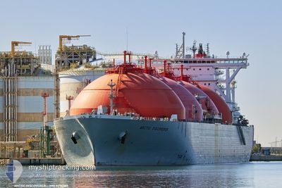
ARCTIC DISCOVERER
Lng Tanker
Current Trip
| Time Travelled | 15 days |
|---|---|
| Remaining Time | --- |
| Distance Travelled | 2172.19 nm |
| Remaining Distance | --- |
| AVG Speed | 8.1 Knopen |
| MAX Speed | 11.3 Knopen |
| AVG Wind | 15.2 knots |
| MAX Wind | 43 knots |
| MIN Temp | -2.1°C / 28.22°F |
| MAX Temp | 9.7°C / 49.46°F |
| Diepgang | 10.5 M |
| Positie ontvangen | 1 m geleden |
Current Position
| Lengtegraad | --- |
|---|---|
| Breedtegraat | --- |
| Status | At anchor |
| Snelheid | |
| Koers | 200° |
| Gebied | Norwegian Sea |
| Station | T-AIS |
| Positie ontvangen | 1 m geleden |
Info
Information
The current position of ARCTIC DISCOVERER is in Norwegian Sea with coordinates 70.68231° / 23.39455° as reported on 2025-12-07 10:09 by AIS to our vessel tracker app. The vessel's current speed is 0 Knopen
The vessel ARCTIC DISCOVERER (IMO: 9276389, MMSI: 309481000) is a Lng Tanker that was built in 2006 ( 19 Jaar oud ). It's sailing under the flag of [BS] Bahamas.
In this page you can find informations about the vessels current position, last detected port calls, and current voyage information. If the vessels is not in coverage by AIS you will find the latest position.
The current position of ARCTIC DISCOVERER is detected by our AIS receivers and we are not responsible for the reliability of the data. The last position was recorded while the vessel was in Coverage by the Ais receivers of our vessel tracking app.
The current draught of ARCTIC DISCOVERER as reported by AIS is 10.5 meters
Weather
| Temperature | -0.4°C / 31.28°F |
|---|---|
| Wind Speed | 14 knots |
| Direction | 181° S |
| Pressure | 1018.3 hPa |
| Humidity | 75.2 % |
| Cloud Coverage | 99 % |
Featured Company
Last Port Calls
| Port | Arrival | Departure | Time In Port |
|---|---|---|---|
| 2025-11-20 23:22 | 2025-11-21 22:46 | 23 h | |
| 2025-11-12 16:03 | 2025-11-13 19:00 | 1 d | |
| 2025-11-03 06:26 | 2025-11-04 19:35 | 1 d | |
| 2025-10-24 08:00 | 2025-10-25 08:49 | 1 d | |
| 2025-10-14 02:40 | 2025-10-15 03:26 | 1 d | |
| 2025-10-04 00:27 | 2025-10-05 07:03 | 1 d |
Last Trips
| Origin | Departure | Destination | Arrival | Distance | |
|---|---|---|---|---|---|
| 2025-11-13 19:00 | 2025-11-20 23:22 | 1592.14 nm | |||
| 2025-11-04 19:35 | 2025-11-12 16:03 | 1806.30 nm | |||
| 2025-10-25 08:49 | 2025-11-03 06:26 | 1811.13 nm | |||
| 2025-10-15 03:26 | 2025-10-24 08:00 | 1548.99 nm | |||
| 2025-10-05 07:03 | 2025-10-14 02:40 | 1508.71 nm | |||
| 2025-09-28 00:01 | 2025-10-04 00:27 | 1826.11 nm |
Events
| Tijd | Evenement | Details | Positie / Bestemming | Info |
|---|---|---|---|---|
| 2025-12-03 23:00 | Status Changed | At anchor Default |
70.68121 / 23.39601
NOHFT
|
Snelheid: Koers: 195° |
| 2025-12-03 22:51 | Status Changed | Default At anchor |
70.68124 / 23.39573
NOHFT
|
Snelheid: Koers: 196° |
| 2025-12-03 22:48 | Status Changed | At anchor Default |
70.68126 / 23.39580
NOHFT
|
Snelheid: Koers: 196° |
| 2025-12-03 22:15 | Status Changed | Default At anchor |
70.68153 / 23.39395
NOHFT
|
Snelheid: 0.1 kn Koers: 186° |
| 2025-12-03 22:09 | Status Changed | At anchor Default |
70.68165 / 23.39312
NOHFT
|
Snelheid: 0.1 kn Koers: 183° |
| 2025-12-03 22:03 | Status Changed | Default At anchor |
70.68173 / 23.39243
NOHFT
|
Snelheid: 0.1 kn Koers: 182° |
| 2025-12-03 21:57 | Status Changed | At anchor Default |
70.68180 / 23.39172
NOHFT
|
Snelheid: Koers: 180° |
| 2025-12-03 21:21 | Status Changed | Default At anchor |
70.68208 / 23.39012
NOHFT
|
Snelheid: Koers: 181° |
| 2025-12-03 21:18 | Status Changed | At anchor Default |
70.68208 / 23.39009
NOHFT
|
Snelheid: Koers: 179° |
| 2025-12-03 20:54 | Status Changed | Default At anchor |
70.68202 / 23.38884
NOHFT
|
Snelheid: Koers: 177° |