
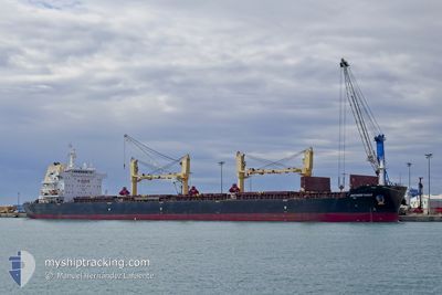
ANTWERP EAGLE
Cargo
Current Trip
| Time Travelled | 3 days |
|---|---|
| Remaining Time | 6 h, 16 mins |
| Distance Travelled | 359.54 nm |
| Remaining Distance | 78.59 nm |
| AVG Speed | 8.1 Knopen |
| MAX Speed | 13.3 Knopen |
| AVG Wind | 11 knots |
| MAX Wind | 24.9 knots |
| MIN Temp | 8°C / 46.4°F |
| MAX Temp | 15.8°C / 60.44°F |
| Diepgang | 6.9 M |
| Positie ontvangen | 2 m geleden |
Current Position
| Lengtegraad | -74.82975° |
|---|---|
| Breedtegraat | 38.67094° |
| Status | At anchor |
| Snelheid | |
| Koers | 77° |
| Gebied | North Atlantic Ocean |
| Station | T-AIS |
| Positie ontvangen | 2 m geleden |
Info
Information
The current position of ANTWERP EAGLE is in North Atlantic Ocean with coordinates 38.67094° / -74.82975° as reported on 2024-04-19 20:46 by AIS to our vessel tracker app. The vessel's current speed is 0 Knopen and is heading at the port of WILMINGTON. The estimated time of arrival as calculated by MyShipTracking vessel tracking app is 2024-04-20 03:04 LT
The vessel ANTWERP EAGLE (IMO: 9699036, MMSI: 538009603) is a Cargo It's sailing under the flag of [MH] Marshall Is.
In this page you can find informations about the vessels current position, last detected port calls, and current voyage information. If the vessels is not in coverage by AIS you will find the latest position.
The current position of ANTWERP EAGLE is detected by our AIS receivers and we are not responsible for the reliability of the data. The last position was recorded while the vessel was in Coverage by the Ais receivers of our vessel tracking app.
The current draught of ANTWERP EAGLE as reported by AIS is 6.9 meters
Weather
| Temperature | 9.6°C / 49.28°F |
|---|---|
| Wind Speed | 3 knots |
| Direction | 74° ENE |
| Pressure | 1019.1 hPa |
| Humidity | 90.1 % |
| Cloud Coverage | 100 % |
Featured Company
Last Port Calls
| Port | Arrival | Departure | Time In Port |
|---|---|---|---|
| 2024-04-08 15:10 | 2024-04-16 02:10 | 7 d | |
| 2024-03-03 22:17 | 2024-03-07 23:44 | 4 d | |
| 2024-02-11 10:27 | |||
| 2024-02-03 19:57 | 2024-02-10 16:12 | 6 d |
Last Trips
| Origin | Departure | Destination | Arrival | Distance | |
|---|---|---|---|---|---|
| 2024-03-07 23:44 | 2024-04-08 11:10 | 5421.95 nm | |||
| 2024-02-10 18:12 | 2024-03-03 22:17 | 3978.58 nm | |||
| 2024-02-10 18:12 | 2024-02-11 12:27 | 62.93 nm | |||
| 2024-01-15 21:28 | 2024-02-03 21:57 | 3130.67 nm |
Events
| Tijd | Evenement | Details | Positie / Bestemming | Info |
|---|---|---|---|---|
| 2024-04-19 17:04 | Stop beweging | 15.24 nm, South East of LEWES |
38.67084 / -74.82848
USILG
|
Snelheid: 0.3 kn Koers: 69° |
| 2024-04-19 16:52 | Status Changed | At anchor Under way using engine |
38.67039 / -74.82551
USILG
|
Snelheid: 0.6 kn Koers: 7° |
| 2024-04-19 15:07 | Status Changed | Under way using engine Default |
38.70341 / -74.60725
USILG
|
Snelheid: 8.6 kn Koers: 227° |
| 2024-04-19 14:41 | Status Changed | Default Under way using engine |
38.74677 / -74.55115
USILG
|
Snelheid: 7.9 kn Koers: 222.5° |
| 2024-04-19 06:53 | Status Changed | Under way using engine Default |
38.67616 / -74.37912
USILG
|
Snelheid: 2.4 kn Koers: 327° |
| 2024-04-19 06:53 | Binnenbereik |
38.67583 / -74.38078
North Atlantic Ocean
|
Snelheid: 3 kn Koers: 257.2° |
|
| 2024-04-19 00:44 | Stop beweging |
38.72224 / -74.06451
USILG
|
Snelheid: 0.2 kn Koers: 22° |
|
| 2024-04-18 14:17 | Status Changed | Default At anchor |
38.72219 / -74.06171
USILG
|
Snelheid: 0.1 kn Koers: 349° |
| 2024-04-18 13:56 | Buitenbereik |
38.72220 / -74.06167
North Atlantic Ocean
|
Snelheid: 0.1 kn Koers: 208.6° |
|
| 2024-04-18 13:29 | Status Changed | At anchor Default |
38.72223 / -74.06160
USILG
|
Snelheid: 0.2 kn Koers: 347° |