
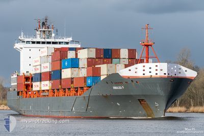
ANNALISA P
Container Ship
Current Trip
| Time Travelled | 22 h, 43 mins |
|---|---|
| Remaining Time | 20 h, 41 mins |
| Distance Travelled | 173.77 nm |
| Remaining Distance | 259.88 nm |
| AVG Speed | 7.9 Knopen |
| MAX Speed | 13.6 Knopen |
| AVG Wind | 9.6 knots |
| MAX Wind | 17.5 knots |
| MIN Temp | 4.2°C / 39.56°F |
| MAX Temp | 10°C / 50°F |
| Diepgang | 8.3 M |
| Positie ontvangen | 1 m geleden |
Current Position
| Lengtegraad | 12.27046° |
|---|---|
| Breedtegraat | 54.50391° |
| Status | Under way using engine |
| Snelheid | 12.1 Knopen |
| Koers | 20.7° |
| Gebied | Baltic Sea |
| Station | T-AIS |
| Positie ontvangen | 1 m geleden |
Info
Information
The current position of ANNALISA P is in Baltic Sea with coordinates 54.50391° / 12.27046° as reported on 2024-04-19 05:17 by AIS to our vessel tracker app. The vessel's current speed is 12.1 Knopen and is heading at the port of GDYNIA. The estimated time of arrival as calculated by MyShipTracking vessel tracking app is 2024-04-20 01:59 LT
The vessel ANNALISA P (IMO: 9437141, MMSI: 305313000) is a Container Ship that was built in 2008 ( 16 Jaar oud ). It's sailing under the flag of [AG] Antigua Barbuda.
In this page you can find informations about the vessels current position, last detected port calls, and current voyage information. If the vessels is not in coverage by AIS you will find the latest position.
The current position of ANNALISA P is detected by our AIS receivers and we are not responsible for the reliability of the data. The last position was recorded while the vessel was in Coverage by the Ais receivers of our vessel tracking app.
The current draught of ANNALISA P as reported by AIS is 8.3 meters
Weather
| Temperature | 5.1°C / 41.18°F |
|---|---|
| Wind Speed | 20 knots |
| Direction | 211° SSW |
| Pressure | 1004.6 hPa |
| Humidity | 95 % |
| Cloud Coverage | 100 % |
Featured Company
Last Port Calls
| Port | Arrival | Departure | Time In Port |
|---|---|---|---|
| 2024-04-16 12:03 | 2024-04-18 06:35 | 1 d | |
| 2024-04-13 11:19 | 2024-04-14 08:49 | 21 h | |
| 2024-04-12 10:56 | 2024-04-13 02:37 | 15 h | |
| 2024-04-11 02:09 | 2024-04-11 02:14 | 4 m | |
| 2024-04-08 19:25 | 2024-04-10 12:47 | 1 d | |
| 2024-04-06 05:11 | 2024-04-06 14:55 | 9 h | |
| 2024-04-05 12:18 | 2024-04-05 21:26 | 9 h | |
| 2024-04-02 11:41 | 2024-04-03 21:00 | 1 d | |
| 2024-04-01 22:25 | 2024-04-01 23:07 | 42 m | |
| 2024-03-30 17:27 | 2024-03-31 06:03 | 12 h |
Most Visited Ports (Last year)
| Port | Arrivals | |
|---|---|---|
| 44 | ||
| 43 | ||
| 41 | ||
| 29 | ||
| 8 |
Last Trips
| Origin | Departure | Destination | Arrival | Distance | |
|---|---|---|---|---|---|
| 2024-04-14 11:49 | 2024-04-16 14:03 | 505.77 nm | |||
| 2024-04-13 04:37 | 2024-04-13 14:19 | 117.27 nm | |||
| 2024-04-11 04:14 | 2024-04-12 12:56 | 355.47 nm | |||
| 2024-04-10 14:47 | 2024-04-11 04:09 | 88.62 nm | |||
| 2024-04-06 17:55 | 2024-04-08 21:25 | 500.69 nm | |||
| 2024-04-05 23:26 | 2024-04-06 08:11 | 115.89 nm | |||
| 2024-04-03 23:00 | 2024-04-05 14:18 | 444.70 nm | |||
| 2024-04-02 01:07 | 2024-04-02 13:41 | 88.95 nm | |||
| 2024-03-31 09:03 | 2024-04-02 00:25 | 410.74 nm | |||
| 2024-03-30 09:38 | 2024-03-30 19:27 | 118.68 nm |
Events
| Tijd | Evenement | Details | Positie / Bestemming | Info |
|---|---|---|---|---|
| 2024-04-19 04:28 | Gevonden in zee | German part of the Baltic Sea |
54.40098 / 12.07864
Baltic Sea
PLGDY
|
Snelheid: 12.5 kn Koers: 90° |
| 2024-04-19 02:32 | Wijzig zee gebeid | Danish part of the Baltic Sea German part of the Baltic Sea |
54.50422 / 11.44142
Baltic Sea
PLGDY
|
Snelheid: 12.2 kn Koers: 117.4° |
| 2024-04-19 00:31 | Wijzig zee gebeid | German part of the Baltic Sea Danish part of the Baltic Sea |
54.57132 / 10.79111
Baltic Sea
PLGDY
|
Snelheid: 11.9 kn Koers: 85.4° |
| 2024-04-18 23:55 | Wijzig zee gebeid | Danish part of the Baltic Sea German part of the Baltic Sea |
54.55994 / 10.58787
Baltic Sea
PLGDY
|
Snelheid: 11.5 kn Koers: 71.4° |
| 2024-04-18 22:47 | Wijzig zee gebeid | German part of the Baltic Sea German part of the North Sea |
54.46022 / 10.26906
Baltic Sea
PLGDY
|
Snelheid: 13.1 kn Koers: 38.2° |
| 2024-04-18 22:05 | Start beweging | 1.29 nm, South West of STICKENHΟRN SPORT |
54.36541 / 10.14653
PLGDY
|
Snelheid: 3.1 kn Koers: 105° |
| 2024-04-18 21:27 | Stop beweging | 1.39 nm, South West of STICKENHΟRN SPORT |
54.36642 / 10.13999
PLGDY
|
Snelheid: 0.2 kn Koers: 104° |
| 2024-04-18 12:42 | Start beweging | 0.55 nm, South West of BRUNSBUETTEL |
53.89589 / 9.15010
PLGDY
|
Snelheid: 4.7 kn Koers: 49° |
| 2024-04-18 11:55 | Stop beweging | 0.76 nm, South West of BRUNSBUETTEL |
53.89361 / 9.14534
PLGDY
|
Snelheid: Koers: 47° |
| 2024-04-18 10:54 | Start beweging | 1.71 nm, South East of BRUNSBUETTEL |
53.88250 / 9.19290
PLGDY
|
Snelheid: 3.9 kn Koers: 265° |