
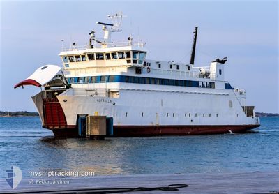
ALFAGELN
Passenger
Current Trip
HUMMELVIK/TORSHOLMA
| Time Travelled | --- |
|---|---|
| Remaining Time | --- |
| Distance Travelled | 2454.26 nm |
| Remaining Distance | --- |
| AVG Speed | 11.3 Knopen |
| MAX Speed | 14.9 Knopen |
| AVG Wind | 12.9 knots |
| MAX Wind | 41.7 knots |
| MIN Temp | -6.3°C / 20.66°F |
| MAX Temp | 8.8°C / 47.84°F |
| Diepgang | 3.8 M |
| Positie ontvangen | 1 d geleden |
Current Position
| Lengtegraad | 21.00834° |
|---|---|
| Breedtegraat | 60.31902° |
| Status | Under way using engine |
| Snelheid | 10.7 Knopen |
| Koers | 234.4° |
| Gebied | Gulf of Bothnia |
| Station | T-AIS |
| Positie ontvangen | 1 d geleden |
Info
Information
The current position of ALFAGELN is in Gulf of Bothnia with coordinates 60.31902° / 21.00834° as reported on 2024-04-19 05:16 by AIS to our vessel tracker app. The vessel's current speed is 10.7 Knopen
The vessel ALFAGELN (IMO: 891570, MMSI: 230992670) is a Passenger It's sailing under the flag of [FI] Finland.
In this page you can find informations about the vessels current position, last detected port calls, and current voyage information. If the vessels is not in coverage by AIS you will find the latest position.
The current position of ALFAGELN is detected by our AIS receivers and we are not responsible for the reliability of the data. The last position was recorded while the vessel was in Coverage by the Ais receivers of our vessel tracking app.
The current draught of ALFAGELN as reported by AIS is 3.8 meters
Weather
| Temperature | -1.6°C / 29.12°F |
|---|---|
| Wind Speed | 21 knots |
| Direction | 351° N |
| Pressure | 1010.9 hPa |
| Humidity | 89.9 % |
| Cloud Coverage | 100 % |
Featured Company
Last Port Calls
Most Visited Ports (Last year)
| Port | Arrivals | |
|---|---|---|
| 1 |
Last Trips
| Origin | Departure | Destination | Arrival | Distance |
|---|
Events
| Tijd | Evenement | Details | Positie / Bestemming | Info |
|---|---|---|---|---|
| 2024-04-20 12:21 | Stop beweging | 4.74 nm, North East of SNACKO |
60.29055 / 20.79020
HUMMELVIK/TORSHOLMA
|
Snelheid: Koers: 195° |
| 2024-04-19 20:39 | Stop beweging | 7.25 nm, North East of LANGNAS |
60.22410 / 20.41425
HUMMELVIK/TORSHOLMA
|
Snelheid: Koers: 116° |
| 2024-04-19 05:16 | Buitenbereik |
60.31902 / 21.00834
Gulf of Bothnia
|
Snelheid: 10.7 kn Koers: 234.4° |
|
| 2024-04-19 05:16 | Binnenbereik |
60.31902 / 21.00834
Gulf of Bothnia
|
Snelheid: 10.7 kn Koers: 234.4° |
|
| 2024-04-17 21:01 | Stop beweging | 7.25 nm, North East of LANGNAS |
60.22409 / 20.41431
HUMMELVIK/TORSHOLMA
|
Snelheid: Koers: 117° |
| 2024-04-16 09:03 | Start beweging | 7.63 nm, North of OVERO |
60.23352 / 20.44015
HUMMELVIK/TORSHOLMA
|
Snelheid: 13.1 kn Koers: 44° |
| 2024-04-16 03:14 | Start beweging | 4.53 nm, North of SNACKO |
60.29319 / 20.71245
HUMMELVIK/TORSHOLMA
|
Snelheid: 13.3 kn Koers: 49° |
| 2024-04-15 09:26 | Stop beweging | 11.02 nm, South West of VUOSNAINEN |
60.35645 / 21.03818
HUMMELVIK/TORSHOLMA
|
Snelheid: Koers: 352° |
| 2024-04-15 08:56 | Start beweging | 11.35 nm, South West of VUOSNAINEN |
60.34992 / 21.03789
HUMMELVIK/TORSHOLMA
|
Snelheid: 10.6 kn Koers: 16° |
| 2024-04-15 08:41 | Stop beweging | 10.02 nm, North East of SNACKO |
60.31745 / 20.99622
HUMMELVIK/TORSHOLMA
|
Snelheid: Koers: 266° |