
AC-D
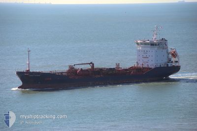
Oil/Chemical Tanker
Current Trip
| Time Travelled | 4 days |
|---|---|
| Remaining Time | --- |
| Distance Travelled | 1378.73 nm |
| Remaining Distance | --- |
| AVG Speed | 11.9 Knopen |
| MAX Speed | 14 Knopen |
| AVG Wind | 17.9 knots |
| MAX Wind | 27.9 knots |
| MIN Temp | 4.8°C / 40.64°F |
| MAX Temp | 10.6°C / 51.08°F |
| Diepgang | 6.1 M |
| Positie ontvangen | 3 h, 50 m geleden |
Current Position
| Lengtegraad | -5.55633° |
|---|---|
| Breedtegraat | 49.00083° |
| Status | Under way using engine |
| Snelheid | 13.2 Knopen |
| Koers | 241° |
| Gebied | Celtic Sea |
| Station | T-AIS |
| Positie ontvangen | 3 h, 50 m geleden |
Info
Information
The current position of AC-D is in Celtic Sea with coordinates 49.00083° / -5.55633° as reported on 2024-04-18 05:47 by AIS to our vessel tracker app. The vessel's current speed is 13.2 Knopen and is heading at the port of YALOVA. The estimated time of arrival as calculated by MyShipTracking vessel tracking app is 2024-04-27 18:00 LT
The vessel AC-D (IMO: 9428437, MMSI: 256934000) is a Oil/Chemical Tanker that was built in 2008 ( 16 Jaar oud ). It's sailing under the flag of [MT] Malta.
In this page you can find informations about the vessels current position, last detected port calls, and current voyage information. If the vessels is not in coverage by AIS you will find the latest position.
The current position of AC-D is detected by our AIS receivers and we are not responsible for the reliability of the data. The last position was recorded while the vessel was in Coverage by the Ais receivers of our vessel tracking app.
The current draught of AC-D as reported by AIS is 6.1 meters
Weather
| Temperature | 10.7°C / 51.26°F |
|---|---|
| Wind Speed | 13 knots |
| Direction | 63° ENE |
| Pressure | 1024.5 hPa |
| Humidity | 68.5 % |
| Cloud Coverage | 98 % |
Featured Company
Last Port Calls
| Port | Arrival | Departure | Time In Port |
|---|---|---|---|
| 2024-04-08 20:05 | 2024-04-13 13:50 | 4 d | |
| 2024-04-03 15:10 | 2024-04-05 15:49 | 2 d | |
| 2024-03-31 11:15 | 2024-04-01 11:02 | 23 h | |
| 2024-03-28 17:21 | 2024-03-29 20:21 | 1 d | |
| 2024-03-21 22:25 | 2024-03-23 13:19 | 1 d | |
| 2024-03-20 01:49 | 2024-03-21 10:05 | 1 d | |
| 2024-03-15 15:55 | 2024-03-17 17:07 | 2 d | |
| 2024-03-01 03:22 | 2024-03-05 15:03 | 4 d | |
| 2024-02-27 08:50 | |||
| 2024-02-10 19:06 | 2024-02-11 21:24 | 1 d |
Most Visited Ports (Last year)
| Port | Arrivals | |
|---|---|---|
| 4 | ||
| 3 | ||
| 3 | ||
| 2 | ||
| 2 | ||
| 2 |
Last Trips
| Origin | Departure | Destination | Arrival | Distance | |
|---|---|---|---|---|---|
| 2024-04-05 17:49 | 2024-04-08 23:05 | 856.32 nm | |||
| 2024-04-01 13:02 | 2024-04-03 17:10 | 343.07 nm | |||
| 2024-03-29 21:21 | 2024-03-31 13:15 | 297.79 nm | |||
| 2024-03-23 14:19 | 2024-03-28 18:21 | 188.87 nm | |||
| 2024-03-21 11:05 | 2024-03-21 23:25 | 146.47 nm | |||
| 2024-03-17 18:07 | 2024-03-20 02:49 | 152.76 nm | |||
| 2024-03-05 16:03 | 2024-03-15 16:55 | 2533.03 nm | |||
| 2024-02-27 09:50 | 2024-03-01 04:22 | 765.00 nm | |||
| 2024-02-04 11:36 | 2024-02-10 20:06 | 708.02 nm | |||
| 2024-01-30 04:14 | 2024-02-04 07:16 | 1459.01 nm |
Events
| Tijd | Evenement | Details | Positie / Bestemming | Info |
|---|---|---|---|---|
| 2024-04-18 06:09 | Status Changed | Default Under way using engine |
48.96073 / -5.66620
TRYLA
|
Snelheid: 13.2 kn Koers: 241° |
| 2024-04-18 05:47 | Buitenbereik |
49.00083 / -5.55633
Celtic Sea
TRYLA
|
Snelheid: 13.2 kn Koers: 241° |
|
| 2024-04-18 05:17 | Status Changed | Under way using engine Default |
49.05599 / -5.40667
TRYLA
|
Snelheid: 13.4 kn Koers: 241° |
| 2024-04-18 05:03 | Status Changed | Default Under way using engine |
49.08186 / -5.33750
TRYLA
|
Snelheid: 14 kn Koers: 240° |
| 2024-04-18 04:53 | Status Changed | Under way using engine Default |
49.10136 / -5.28519
TRYLA
|
Snelheid: 13.4 kn Koers: 240° |
| 2024-04-18 04:32 | Status Changed | Default Under way using engine |
49.14059 / -5.18147
TRYLA
|
Snelheid: 13.6 kn Koers: 240° |
| 2024-04-18 04:21 | Gevonden in zee | French part of the Celtic Sea |
49.16020 / -5.12915
Celtic Sea
TRYLA
|
Snelheid: 13.6 kn Koers: 240° |
| 2024-04-18 04:21 | Status Changed | Under way using engine Default |
49.16083 / -5.12750
TRYLA
|
Snelheid: 13.7 kn Koers: 240° |
| 2024-04-18 03:50 | Status Changed | Default Under way using engine |
49.21600 / -4.97967
TRYLA
|
Snelheid: 13.3 kn Koers: 239° |
| 2024-04-18 03:43 | Status Changed | Under way using engine Default |
49.22904 / -4.94493
TRYLA
|
Snelheid: 13.1 kn Koers: 240° |